

Elevation
Population
Real Population (5km)
Air Quality Rating
Region
Walkability
Housing availability
Avg Download Speed (Mbps) / Avg Upload Speed (Mbps)
Climate Description
Umbria
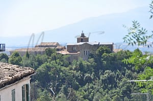
Historic town in Umbria; features medieval architecture, vibrant local festivals, and good healthcare.
Quality of Life Score
55
Quality of Infrastructure
55
Quality of Economy
68
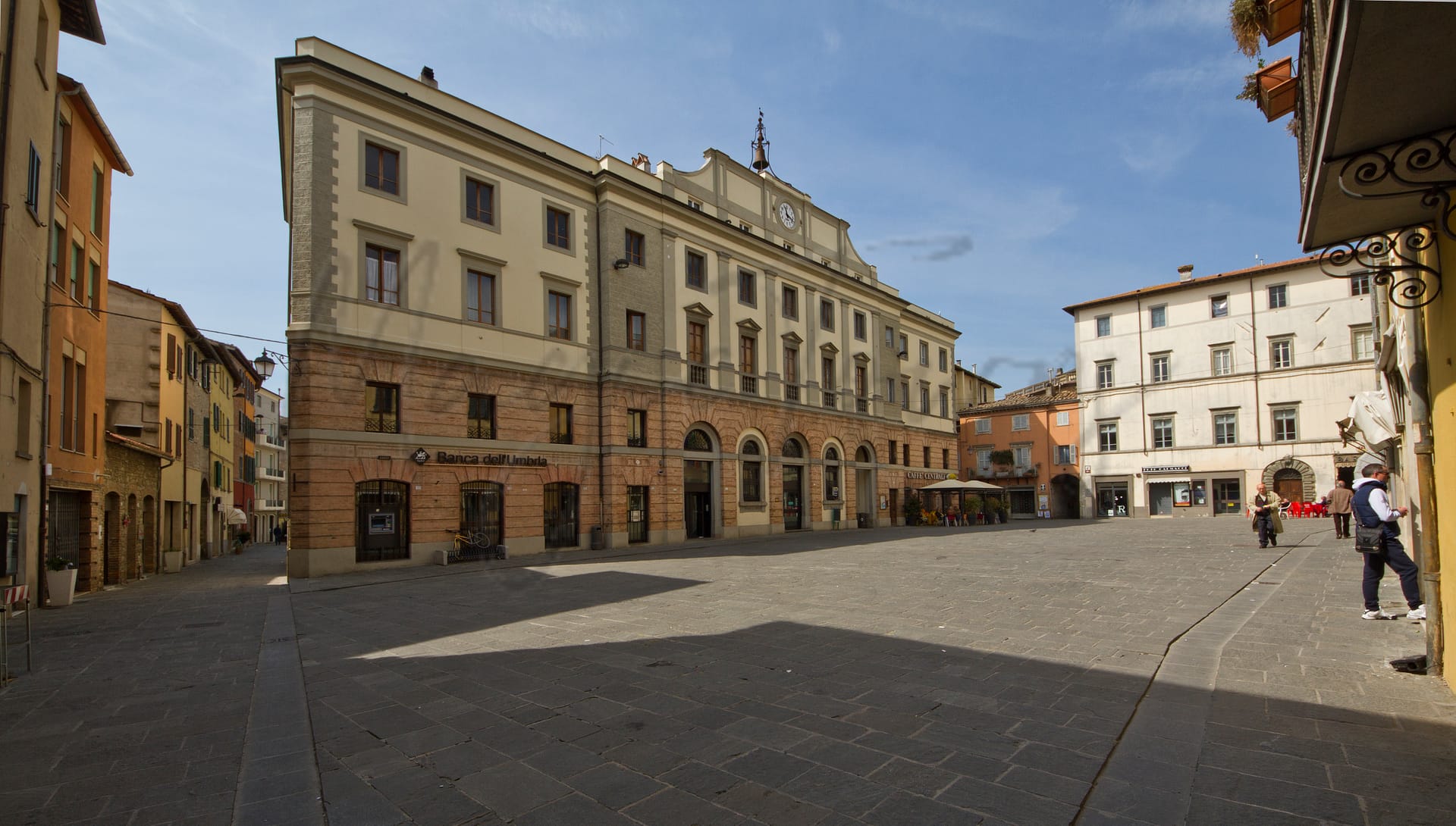
Nestled in the heart of Umbria, Umbertide is a charming town that caters well to foreign expats and retirees seeking a quieter lifestyle. Approximately a 28-minute drive from the nearest airport, it is conveniently situated with easy access to major cities while maintaining a serene atmosphere. Umbertide features a rich historical tapestry, showcased through its medieval architecture and vibrant local festivals, which reflect centuries of tradition and culture. Key attractions include the notable Church of San Francesco and the beautiful surrounding countryside, ideal for leisurely explorations.
While the town offers a peaceful, authentic Italian experience, it faces challenges typical of smaller communities. The Walk Score of Umbertide is notably low, emphasizing a lack of urban infrastructure that may limit mobility for those reliant on walking or public transport. Nevertheless, the town’s commendable healthcare standards and good air quality make it an appealing option for those seeking a balanced lifestyle in a picturesque setting.
– Charming historical architecture and rich cultural heritage.
– Strong sense of community and local integration opportunities.
– Excellent air quality for a healthier lifestyle.
– Low unemployment rate ensures economic stability.
– Peaceful, non-touristic environment for relaxed living.
– Moderate climate suitable for year-round outdoor activities.
– Adequate infrastructure for everyday needs and transportation.
– Access to quality healthcare services in the region.
– Affordable cost of living compared to larger cities.
– Scenic landscapes and beautiful countryside surrounding Umbertide.
– Limited healthcare facilities may lead to longer wait times.
– Public transportation options are somewhat limited to essential routes.
– Internet connectivity can be inconsistent, hindering remote work.
– Fewer educational facilities may not meet diverse family needs.
– Cultural activities may be limited outside major tourist centers.
– Local shops may lack variety for diverse shopping preferences.
– Potential language barrier may hinder integration for some expats.
– Seasonal weather may impact outdoor activities and lifestyle.
– Smaller community means fewer entertainment options available.
– Economic opportunities may be limited for job seekers.
Population
16300
Real Population (5km band)
18300
Births Per 100 Deaths
60.0
Population Data Source
ISTAT,2023
Estimated Unemployment Rate
Touristy Index
Not Touristic
Income per capita (2023)
20200
Income rank in Italy (2023)
4074 out of 7901
Closest Airport
Name
Perugia-San Francesco d'Assisi (Perugia)
Connectivity Score
5
Driving Time
28min(s)
Perugia San Francesco d’Assisi – Umbria International Airport is located in the Umbria region of central Italy, serving the city of Perugia. It primarily offers seasonal flights through airlines such as British Airways and Ryanair, connecting passengers to key European cities like London, Barcelona, and Rome, along with domestic destinations such as Cagliari and Palermo. Not fitting the profile of a major hub, the airport is characterised by its modest passenger numbers but has experienced significant growth recently, making it an accessible entry point to Umbria via road, rail, and regional bus services.
2nd Closest Airport
Name
Raffaello Sanzio (Ancona)
Connectivity Score
6
Driving Time
77min(s)
Raffaello Sanzio Airport, also known as Ancona International Airport, is located 12 km west of Ancona in Falconara Marittima, Italy. It caters to over 460,000 passengers annually, with routes primarily across Europe. Major destinations include Munich, London, Paris, and Barcelona, and it hosts airlines such as Ryanair, Lufthansa, and Volotea, offering both seasonal and year-round flights. This airport serves as a gateway to the Marche region, with a mix of business and leisure travel options, connecting internationally through hub airports like Munich.
3rd Closest Airport
Name
Ampugnano (Siena)
Connectivity Score
1
Driving Time
84min(s)
Siena Ampugnano Airport is located near Siena in Tuscany, Italy, operating primarily as a former small military airfield. With a single runway designated 18/36, it serves a limited number of flights mainly for general aviation. The airport features basic facilities such as refuelling, a flying school at the Aero Club di Siena, and a small restaurant-bar, catering primarily to private and charter flights rather than significant commercial routes.
Closest Rail
Name
Stazione di Monte Corona
Connectivity Score
5
Driving Time
10min(s)
Train service at Stazione di Monte Corona offers the following key features:
– **Rail Lines**: Primarily serviced by regional train lines.
– **Key Destinations**: Connects directly to significant cities such as Perugia and Città di Castello, enhancing accessibility for local commuters and tourists alike.
– **Train Operators**: Primarily operated by Trenitalia with regional services.
– **Frequency of Departures**: Departures generally occur on an hourly basis, though there are fewer services during the evenings and weekends.
– **Type of Trains**: The station caters predominantly to regional trains, with no high-speed services available.
2nd Closest Rail
Name
Stazione di Città di Castello-Zona Industriale
Connectivity Score
4
Driving Time
23min(s)
Train service at Stazione di Città di Castello-Zona Industriale includes the following:
– **Rail lines that stop here**: The station is located on the Ferrovia Centrale Umbra.
– **Key destinations connected by direct trains**: Trains provide direct services to Sansepolcro, Cerbara, and Terni.
– **Train operators**: The station is primarily served by Trenitalia.
– **Frequency of departures**: Specific frequency information is not detailed, though it operates on a scheduled basis.
– **Type of trains**: The services predominantly include regional trains, and there is no indication of high-speed train services at this station.
3rd Closest Rail
Name
Stazione di Città di Castello
Connectivity Score
6
Driving Time
24min(s)
Train service at Stazione di Città di Castello includes regional lines operated mainly by Trenitalia. Key destinations connected by direct trains include Perugia, Arezzo, and Florence. Departures generally occur hourly, offering a consistent service throughout the day. The station does not accommodate high-speed trains; it primarily serves regional services, ensuring access to nearby cities and towns in Umbria and beyond.
Within 10km
Auto Repair Shops
0
Bars
30
Cafes
45
Cinemas
1
Dentists
7
Golf Courses
0
Gyms
2
Health Clinics
18
Hiking Trails
0
Historical Sites
43
Libraries
0
Museums
1
Parks
0
Pharmacies
0
Restaurants
3
Shopping Centres
0
Supermarkets
0
Spas
10
Beach
Name
Camping Europa
Driving Distance
35mins
Water Quality Rating
1 - Excellent
Mountain Resort
Name
Piobbico
Driving Distance
63mins
Healthcare Score
17
Nearest Hospital Name
Umbertide-Pronto Soccorso
Drive Time to Nearest Hospital
9 minutes
Hospitals and Clinics Within 10km
0
Local Public Healthcare Provider
AUSL UMBRIA N. 1
Healthcare Quality Description
In this area of Umbria, healthcare quality presents a mixed picture. While the management of heart attack readmissions is among the national leaders, overall hospital care and treatment speed are below average in Italy. The treatment of bone fractures and breast cancer through minimally invasive surgery is notably slower, with longer patient stays than seen elsewhere. The efficiency in handling serious cardiac events within crucial time limits and readmission rates post-heart failure requires further development. Prospective residents should weigh these factors carefully alongside other considerations when evaluating the healthcare provisions available in this region.
Seismic Zone (risk of earthquakes)
Moderate Earthquake Risk
Road Accidents Rate per 10k Inhabitants
25
Percentage of Population at Landslide Risk
3
Percentage of Population at Flood Risk
5
Car Insurance Price Index
101.576
Housing availability
Low
Property Prices per m²
First Quartile
622
Median
745
Third Quartile
1078
Walkability Description
Walker's Paradise
Avg Download Speed (Mbps)
70
Fast Download Speed (Mbps)
87
Slow Download Speed (Mbps)
35
Avg Schools Ranking (All Criteria)
Top 30%
Avg Schools Ranking (Standardised Tests)
Top 40%
Counts of School
| Town/City | Primary Schools | Kindergartens | Comprehensive Schools | Medium High Schools | Scientific High Schools | Technical Commercial Schools | Classical High Schools | Industrial Technical Schools | Higher Education Institutes |
|---|---|---|---|---|---|---|---|---|---|
| Umbertide | 7 | 6 | 1 | 1 | 1 | N/A | N/A | 1 | 1 |
Precipitation
Somewhat Low (21st-30th percentile)
Sunshine
Average (41st-50th percentile)
Snowfall
Below Average (31st-40th percentile)
Min Annual Temperature (°C)
1.8
Max Annual Temperature (°C)
30.3
Climate Description
Umbertide enjoys a temperate climate characterized by modest seasonal variations. In the winter, temperatures are mild with occasional snowfall, creating a picturesque setting without severe cold. Summers provide warmth without the extremes, making it comfortable for outdoor activities and exploration. The town benefits from ample sunshine throughout the year, ensuring that days are generally bright, enhancing the scenic landscapes and historic architecture. Rainfall is well-distributed across the months, supporting lush vegetation and the agricultural surroundings typical of this region of Italy. This climate supports a leisurely lifestyle, ideal for retirees and expats seeking a serene environment.
Annual Temperature Chart (Min)
Climate data provided by Open Meteo, based on 2010–2022 averages.
| Town | Min Temp Jan | Min Temp Feb | Min Temp Mar | Min Temp Apr | Min Temp May | Min Temp Jun | Min Temp Jul | Min Temp Aug | Min Temp Sep | Min Temp Oct | Min Temp Nov | Min Temp Dec |
|---|---|---|---|---|---|---|---|---|---|---|---|---|
| Umbertide | 1,80 | 2,20 | 4,70 | 7,90 | 11,10 | 15,60 | 18,80 | 18,70 | 15,10 | 11,30 | 7,40 | 2,90 |
Annual Temperature Chart (Max)
Climate data provided by Open Meteo, based on 2010–2022 averages.
| Town | Max Temp Jan | Max Temp Feb | Max Temp Mar | Max Temp Apr | Max Temp May | Max Temp Jun | Max Temp Jul | Max Temp Aug | Max Temp Sep | Max Temp Oct | Max Temp Nov | Max Temp Dec |
|---|---|---|---|---|---|---|---|---|---|---|---|---|
| Umbertide | 8,9 | 9,90 | 13,90 | 18,10 | 20,80 | 27,00 | 30,30 | 30,30 | 24,80 | 19,90 | 14,40 | 10,00 |
Sunny Days By Month
Climate data provided by Open Meteo, based on 2010–2022 averages.
| Town | Sunny Days % Jan | Sunny Days % Feb | Sunny Days % Mar | Sunny Days % Apr | Sunny Days % May | Sunny Days % Jun | Sunny Days % Jul | Sunny Days % Aug | Sunny Days % Sep | Sunny Days % Oct | Sunny Days % Nov | Sunny Days % Dec |
|---|---|---|---|---|---|---|---|---|---|---|---|---|
| Umbertide | 39 | 35 | 48 | 51 | 55 | 69 | 74 | 75 | 57 | 40 | 28 | 43 |
Classifications
PM10
Good
PM2.5
Good
NO2
Good
SO2
Good
O₃
Fair
Air Quality Rating
90
Air Quality Description
Nestled in the verdant landscapes of Italy, Umbertide presents its residents with a generally pleasing air quality profile. The ambient measures of particulate matter (PM10 and PM2.5) consistently lie within satisfactory levels, indicating a healthy breathing environment. Nitrogen dioxide and sulphur dioxide, potential irritants, are found in minimal concentrations, further marking the town as a favorable and comfortable setting for daily activities. There is, however, a moderate presence of ozone which while not alarming, suggests a need for occasional caution during high-exposure activities. Such conditions make Umbertide a practical choice for those seeking a clean and agreeable air quality away from urban pollutants.
Nestled in the verdant landscapes of Italy, Umbertide presents its residents with a generally pleasing air quality profile. The ambient measures of particulate matter (PM10 and PM2.5) consistently lie within satisfactory levels, indicating a healthy breathing environment. Nitrogen dioxide and sulphur dioxide, potential irritants, are found in minimal concentrations, further marking the town as a favorable and comfortable setting for daily activities. There is, however, a moderate presence of ozone which while not alarming, suggests a need for occasional caution during high-exposure activities. Such conditions make Umbertide a practical choice for those seeking a clean and agreeable air quality away from urban pollutants.
Getting There
Umbertide is connected via the E45 and SP220 roads, facilitating access to nearby cities. The nearest airport is Perugia-San Francesco d’Assisi, 28 minutes away, and Ancona’s Raffaello Sanzio airport is 77 minutes distant. Train stations nearby offer limited connectivity, with scores of 5 and 4 out of 10 respectively.
Getting Around
Local Cuisine
Umbertide, located in the scenic region of Umbria, offers a rich culinary landscape characterized by traditional dishes such as truffles, lentils, focaccias, and various pig-derived charcuterie. Notable specialties include Pasta alla Norcina, Strangozzi, and Torta al testo, reflecting the local farm-to-table ethos and a commitment to utilizing regional ingredients. The town boasts a variety of dining options, ranging from casual eateries serving authentic Umbrian cuisine to more sophisticated international venues, catering to diverse tastes. Umbertide is also home to Michelin-starred restaurants that elevate the local culinary experience, underscoring the region’s culinary significance.
Shopping Overview
Shopping in the region offers diverse options, including well-stocked supermarkets providing essential groceries, as well as local markets featuring fresh produce and artisanal foods. Regular general markets occur weekly, featuring clothing and handcrafts. Specialty shops and boutiques offer curated selections of fashion and gifts. The area does not host major shopping malls, but a variety of smaller shopping venues cater to different tastes and needs, enhancing the local shopping experience for expats and retirees.
Neighborhoods
Green Areas and Parks
Umbertide offers several notable outdoor activities, including intermediate-level hiking trails. Among them are the Croce di Monte Acuto – Cima Cerchiaia loop, which spans approximately 6.31 miles, and the Abbazia di Monte Corona loop, measuring 6 miles. The area also features the CAI Umbria Trail from Spedalicchio to Preggio, a 10.2 km route. Additionally, hikers can explore the Village of Santa Giuliana to Hermitage of Monte Corona, a 5.64-mile loop. These trails offer scenic routes through the region’s landscape, providing various options for hiking enthusiasts.
✅ Pros
– Charming historical architecture and rich cultural heritage.
– Strong sense of community and local integration opportunities.
– Excellent air quality for a healthier lifestyle.
– Low unemployment rate ensures economic stability.
– Peaceful, non-touristic environment for relaxed living.
– Moderate climate suitable for year-round outdoor activities.
– Adequate infrastructure for everyday needs and transportation.
– Access to quality healthcare services in the region.
– Affordable cost of living compared to larger cities.
– Scenic landscapes and beautiful countryside surrounding Umbertide.
❌ Cons
– Limited healthcare facilities may lead to longer wait times.
– Public transportation options are somewhat limited to essential routes.
– Internet connectivity can be inconsistent, hindering remote work.
– Fewer educational facilities may not meet diverse family needs.
– Cultural activities may be limited outside major tourist centers.
– Local shops may lack variety for diverse shopping preferences.
– Potential language barrier may hinder integration for some expats.
– Seasonal weather may impact outdoor activities and lifestyle.
– Smaller community means fewer entertainment options available.
– Economic opportunities may be limited for job seekers.
FAQs
No posts found for the town.
Our innovative AI assistant is eager to help. Try it out for free here: