
Elevation
[?]
Elevation of a city refers to the height above sea level at which the city is located, measured in meters.
17
Population
[?]
This is a town's official population, measured each year by the national statistics authority.
10800
Real Population (5km)
[?]
Our "Real Population" metric reflects more accurately a town's real size by including inhabitants in the immediate vicinity of the town's official borders.
50100
Air Quality Rating
[?]
Based on PM10, PM2.5, NO2, SO2, and ozone levels. Higher scores indicate cleaner air.
82
Region
Emilia-Romagna
Walkability
Very Walkable
Housing availability
[?]
Based on total number of properties (sale and rent) classifies housing availability into five categories: low, relativel ylow, medium, relatively high and high.
Low
Avg Download Speed (Mbps) / Avg Upload Speed (Mbps)
103
/ 46
Climate Description
Temperate climate with mild warmth, moderate rainfall, and occasional light snow in winter.
San Felice sul Panaro
Emilia-Romagna
Historic town known for culinary traditions, cycling paths, and proximity to Modena.
Quality of Life Score
[?]Factors in air quality, amenities, walkability, population, and environmental risks. Higher scores suggest better living conditions.
81
Quality of Infrastructure
[?]Measures internet speed, healthcare access, airports, rail, and walkability. Higher scores mean better connectivity and essential services.
61
Quality of Economy
[?]Based on income, property prices, job availability, and population density. Higher scores indicate stronger economic conditions.
76
San Felice sul Panaro Demographics
Population
[?]
This is a town's official population, measured each year by the national statistics authority.
10800
Real Population (5km band)
[?]
Our "Real Population" metric reflects more accurately a town's real size by including inhabitants in the immediate vicinity of the town's official borders.
50100
Births Per 100 Deaths
40.0
Population Data Source
ISTAT,2023
Estimated Unemployment Rate
Touristy Index
[?]
Calculation of tourist density index for the city, comparing its total tourist number to the overall average tourist number of the region
relative to its own population.The index indicates how a location’s tourist density compares to the average, with values above
100 representing higher-than-average density and values below 100 representing lower-than-average density.
Not Touristic
Income per capita (2023)
[?]
This is an estimation of average income per resident for this town, based on 2023 data from the Italian Ministry of Finance.
23100
Income rank in Italy (2023)
[?]
This is a ranking of the town's average income per resident, against the full list of townships in Italy.
1631 out of 7901
Infrastructure and Connectivity
Create an account to explore more
This content is for Members only | Already a Member? Sign in
Infrastructure & Amenities
Create an account to explore more
This content is for Members only | Already a Member? Sign in
Healthcare
Create an account to explore more
This content is for Members only | Already a Member? Sign in
Housing & Property Market
Create an account to explore more
This content is for Members only | Already a Member? Sign in
Connectivity & Digital Access
Create an account to explore more
This content is for Members only | Already a Member? Sign in
Education
Create an account to explore more
This content is for Members only | Already a Member? Sign in
Climate & Weather
Create an account to explore more
This content is for Members only | Already a Member? Sign in
Precipitation
[?] Based on daily climate data for precipitation from OPEN-METEO this parameter indicates how a city's annual precipitation compares to others in terms of percentage, with values ranging from 0 (lowest) to 1 (highest). For example, a percentile rank of 0.75 means the city's total precipitation is higher than 75% of other cities.
Low (11th-20th percentile)
Sunshine
Above Average (51st-60th percentile)
Snowfall
Below Average (31st-40th percentile)
Min Annual Temperature (°C)
[?] This parameter represents the monthly average of daily minimum temperatures for January, based on data from OPEN-METEO.
0.3
Max Annual Temperature (°C)
[?] This parameter represents the monthly average of daily minimum temperatures for January, based on data from OPEN-METEO.
31.2
Climate Description
San Felice sul Panaro enjoys a temperate climate, marked by distinct seasons that cater well to both expats and retirees seeking a slice of Italian charm. The weather tends towards mild warmth for most of the year, cooling comfortably at winter's touch while rarely succumbing to severe cold. Summers offer sun-soaked days allowing for ample enjoyment of local vineyards and outdoor festivals. Although rainfall is moderate, it’s typically well-distributed throughout the year, ensuring lush landscapes that remain green and vibrant. Winter occasionally drapes the town in light snow, adding a fleeting enchantment without causing major disruptions. Overall, San Felice sul Panaro promises a balanced climate, appealing for those looking to enjoy leisurely days in a picturesque setting.
Annual Temperature Chart (Min)
Error
There was a problem with your SQL connection - Please contact the administrator
There was a problem with your SQL connection - Please contact the administrator
Annual Temperature Chart (Max)
Error
There was a problem with your SQL connection - Please contact the administrator
There was a problem with your SQL connection - Please contact the administrator
Sunny Days By Month
Error
There was a problem with your SQL connection - Please contact the administrator
There was a problem with your SQL connection - Please contact the administrator
Environmental & Air Quality
Create an account to explore more
This content is for Members only | Already a Member? Sign in
Classifications
PM10
[?]
PM10 levels indicate Good air quality at 0–20 µg/m³, Fair at 20–40 µg/m³, Moderate at 40–50 µg/m³, Poor at 50–100 µg/m³, Very Poor at 100–150 µg/m³, and Extremely Poor at 150–1200 µg/m³.
Fair
PM2.5
[?]
PM2.5 is Good if PM2.5 levels are between 0–10 µg/m³, Fair between 10–20 µg/m³, Moderate between 20–25 µg/m³, Poor between 25–50 µg/m³, Very Poor between 50–75 µg/m³, and Extremely Poor between 75–800 µg/m³.
Fair
NO2
[?]
NO₂ levels are considered Good at 0–40 µg/m³, Fair at 40–90 µg/m³, Moderate at 90–120 µg/m³, Poor at 120–230 µg/m³, Very Poor at 230–340 µg/m³, and Extremely Poor at 340–1000 µg/m³.
Good
SO2
[?]
SO₂ levels indicate Good air quality at 0–100 µg/m³, Fair at 100–200 µg/m³, Moderate at 200–350 µg/m³, Poor at 350–500 µg/m³, Very Poor at 500–750 µg/m³, and Extremely Poor at 750–1250 µg/m³.
Good
O₃
[?]
For O₃, the air is Good at 0–50 µg/m³, Fair at 50–100 µg/m³, Moderate at 100–130 µg/m³, Poor at 130–240 µg/m³, Very Poor at 240–380 µg/m³, and Extremely Poor at 380–800 µg/m³.
Fair
Air Quality Rating
[?]
Based on PM10, PM2.5, NO2, SO2, and ozone levels. Higher scores indicate cleaner air.
82
Air Quality Description
San Felice sul Panaro offers a fair balance in terms of air quality. The atmosphere carries PM10 and PM2.5 particles at levels considered reasonable but warrant attention for those especially sensitive to air quality. Ozone presence, similarly characterized as fair, suggests a moderate impact on outdoor activities, particularly in warmer seasons when levels typically rise. Nitrogen and sulfur dioxide, however, are present in notably lower concentrations, falling into the good category and contributing positively to the local living conditions. Residents can generally expect an air environment that supports an active, outdoor lifestyle without significant concern for pollutants.
San Felice sul Panaro offers a fair balance in terms of air quality. The atmosphere carries PM10 and PM2.5 particles at levels considered reasonable but warrant attention for those especially sensitive to air quality. Ozone presence, similarly characterized as fair, suggests a moderate impact on outdoor activities, particularly in warmer seasons when levels typically rise. Nitrogen and sulfur dioxide, however, are present in notably lower concentrations, falling into the good category and contributing positively to the local living conditions. Residents can generally expect an air environment that supports an active, outdoor lifestyle without significant concern for pollutants.
Town Descriptions
Create an account to explore more
This content is for Members only | Already a Member? Sign in
Getting There
San Felice sul Panaro is well-connected through the regional road network, with the A1 motorway and SS12 road providing access to nearby cities. Guglielmo Marconi Airport in Bologna and Reggio Emilia Airport serve as the main air transport hubs, while local train stations enhance rail connectivity.
Getting Around
Local Cuisine
The culinary scene in San Felice sul Panaro, situated in the Emilia-Romagna region of Italy, showcases a rich tapestry of traditional Emilian cuisine. Local specialties include gnocco fritto, crescentine, and tortellini, highlighting the region’s emphasis on pasta dishes and quality meat products. The area is known for its use of fresh ingredients, with an abundant selection of cold cuts, cheeses, and handmade pasta. Dining options are diverse, encompassing family-run trattorias and modern restaurants that celebrate the flavors of the region, often complemented by international influences. Though San Felice sul Panaro may not host Michelin-starred establishments, its culinary offerings reflect the authenticity and depth of this storied gastronomic region, making it a destination for both local and visiting food enthusiasts.
Shopping Overview
The local shopping landscape features diverse categories appealing to expats and retirees. It includes supermarkets for everyday essentials, specialist food shops, and boutiques showcasing regional goods. Malls and larger retail centres offer a broader array of brands, including fashion and homeware, facilitating a comprehensive shopping experience.
Neighborhoods
Green Areas and Parks
San Felice sul Panaro offers a variety of hiking trails and outdoor activities suitable for different skill levels. Notable hikes include the “Via Romea Nonantolana” ring tour, spanning approximately 11 miles, and the “Rocca Estense” loop, covering 5.75 miles. These trails provide moderate challenges and scenic routes. Additionally, the region accommodates easier options such as the Medolla and Villafranca loops. Outdoor enthusiasts can appreciate these well-mapped trails against the backdrop of Emilia-Romagna’s landscape. The area supports both leisurely and intermediate hiking experiences.
✅ Pros
– High-quality healthcare services available locally.
– Good air quality for a healthier lifestyle.
– Low unemployment rate offers economic stability.
– Peaceful, non-touristic environment for relaxed living.
– Access to historical and cultural attractions nearby.
– Opportunities for community integration and local engagement.
– Moderate climate with distinct seasons throughout the year.
– Sufficient transportation options for nearby cities.
– Reliable internet connectivity for remote work or leisure.
– Affordable cost of living compared to larger cities.
❌ Cons
– Limited nightlife options for those seeking vibrant entertainment.
– Infrastructure improvements needed for optimal transportation efficiency.
– Cultural activities may be fewer than in larger cities.
– Local cuisine might not cater to diverse culinary tastes.
– Language barrier can hinder community integration for non-Italian speakers.
– Weather can be too cold during winter months for some.
– Limited shopping options may frustrate avid shoppers.
– Proximity to larger cities means some noise and traffic.
– Small-town pace may feel slow to urban dwellers.
– Educational facilities might not match larger city standards.
FAQs
Summary
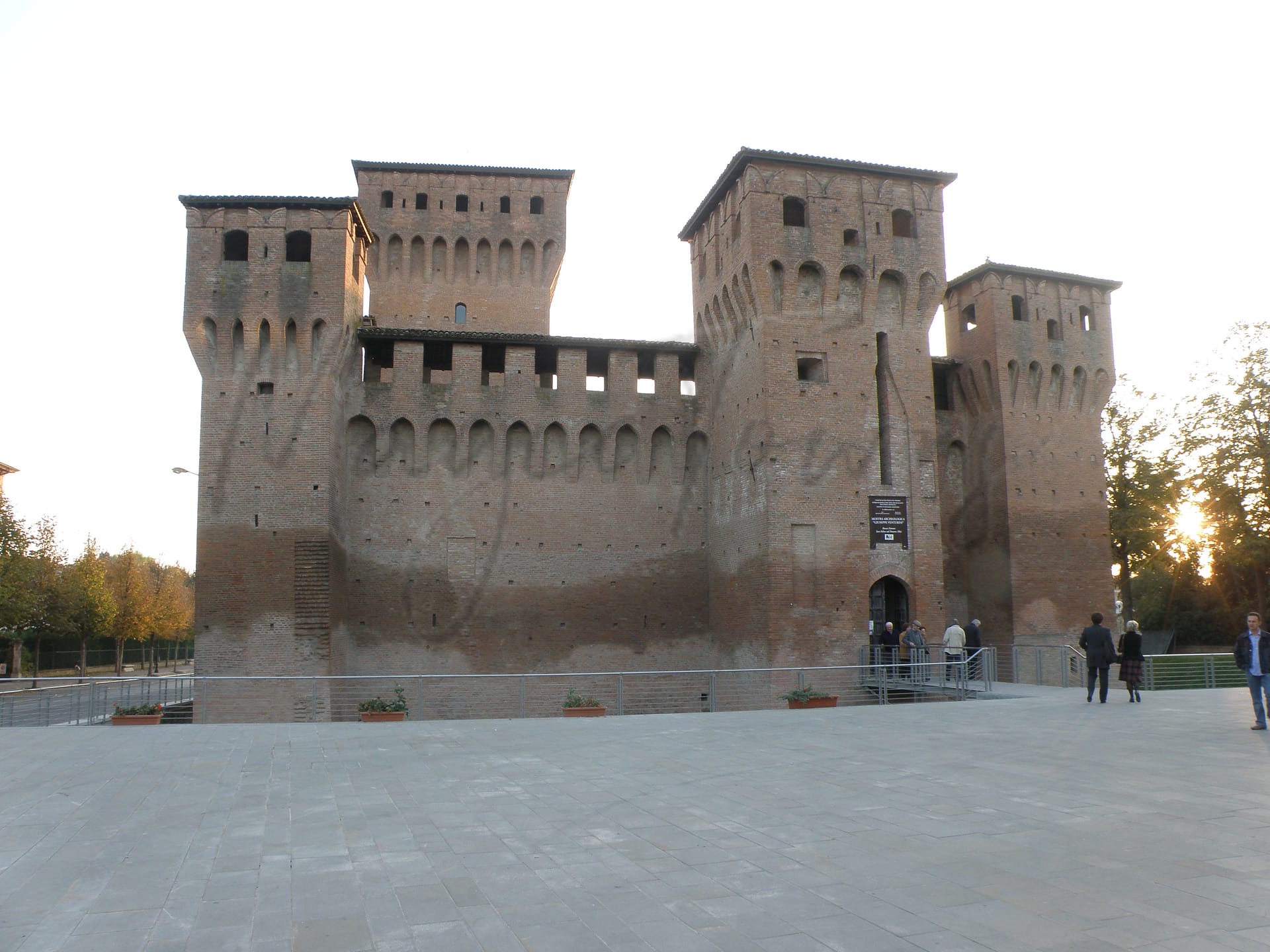
San Felice sul Panaro, located in Emilia-Romagna, offers a blend of historical significance and rural charm. Nestled by the Panaro River, this town features the Rocca Estense, a medieval fortress whose exterior still attracts visitors despite damage from a 2012 earthquake. The area is rich in culinary traditions, known for producing PDO balsamic vinegar, Parmigiano-Reggiano cheese, and locally crafted Lambrusco wine, along with unique cured meats like San Felice salame.
Expatriates will appreciate the town’s bicycle-friendly reputation and its well-maintained cycling paths. Cultural outings include the Church of the Birth of the Virgin, notable for its frescoes, and the La Pica Botanical Garden, home to a diverse range of plants. However, the town’s small population may lack some urban amenities, which could be a consideration for those seeking a more bustling lifestyle. Access to the nearest major city, Modena, is straightforward, enhancing its appeal.
✅ Pros
– High-quality healthcare services available locally.
– Good air quality for a healthier lifestyle.
– Low unemployment rate offers economic stability.
– Peaceful, non-touristic environment for relaxed living.
– Access to historical and cultural attractions nearby.
– Opportunities for community integration and local engagement.
– Moderate climate with distinct seasons throughout the year.
– Sufficient transportation options for nearby cities.
– Reliable internet connectivity for remote work or leisure.
– Affordable cost of living compared to larger cities.
❌ Cons
– Limited nightlife options for those seeking vibrant entertainment.
– Infrastructure improvements needed for optimal transportation efficiency.
– Cultural activities may be fewer than in larger cities.
– Local cuisine might not cater to diverse culinary tastes.
– Language barrier can hinder community integration for non-Italian speakers.
– Weather can be too cold during winter months for some.
– Limited shopping options may frustrate avid shoppers.
– Proximity to larger cities means some noise and traffic.
– Small-town pace may feel slow to urban dwellers.
– Educational facilities might not match larger city standards.
Related Posts
No posts found for the town.
More questions about San Felice sul Panaro ? Ask Magic AI.
Our innovative AI assistant is eager to help. Try it out for free here: