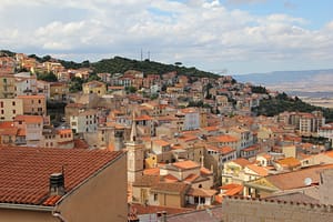
Elevation
Population
Real Population (5km)
Air Quality Rating
Region
Walkability
Housing availability
Avg Download Speed (Mbps) / Avg Upload Speed (Mbps)
Climate Description
Veneto
Quality of Life Score
83
Quality of Infrastructure
47
Quality of Economy
79
– High-quality healthcare services available in the area.
– Low unemployment rate offers economic stability.
– Mild climate with pleasant weather year-round.
– Rich cultural and historical heritage to explore.
– Opportunities for community integration and social activities.
– Access to nearby cities through efficient transportation options.
– Reasonable cost of living compared to larger cities.
– Scenic natural beauty and outdoor recreational activities.
– Satisfactory internet connectivity for remote work and leisure.
– Peaceful environment ideal for retirement and relaxation.
– Limited infrastructure could affect daily life and convenience.
– Air quality not ideal for those with respiratory issues.
– Average internet speeds may frustrate heavy users and gamers.
– Few entertainment options for those seeking a vibrant nightlife.
– Local shops might not offer the variety of larger cities.
– Public transport may not be as frequent or reliable.
– Limited international community for cultural diversity and support.
– Healthcare access might be strained during peak tourist seasons.
– Weather can be too mild for those who love winter.
– Remote work may not be as effective in rural settings.
Population
2800
Real Population (5km band)
80800
Births Per 100 Deaths
90.0
Population Data Source
ISTAT,2023
Estimated Unemployment Rate
Touristy Index
No Data
Income per capita (2023)
23400
Income rank in Italy (2023)
1430 out of 7901
Closest Airport
Name
Connectivity Score
Driving Time
2nd Closest Airport
Name
Connectivity Score
Driving Time
3rd Closest Airport
Name
Connectivity Score
Driving Time
Closest Rail
Name
Stazione di Schio
Connectivity Score
5
Driving Time
14min(s)
Train service at Stazione di Schio is primarily operated by Trenitalia and features the following:
– **Rail Lines**: The station lies on the Vicenza–Schio railway.
– **Key Destinations**: Direct services connect Schio with Vicenza and Thiene.
– **Train Operators**: The primary operator is Trenitalia.
– **Frequency of Departures**: Local train services run frequently, with trains arriving approximately every 30 minutes during peak times.
– **Train Types**: The station primarily offers regional train services, with no high-speed trains operating at this station.
Overall, Stazione di Schio provides crucial connections to nearby towns and the city of Vicenza, ensuring a reliable travel option for both locals and visitors.
2nd Closest Rail
Name
Stazione di Marano Vicentino
Connectivity Score
6
Driving Time
15min(s)
Train service at Stazione di Marano Vicentino is primarily operated by Trenitalia, featuring regional trains. The main rail line that stops here is the one connecting Schio and Vicenza. Key destinations that are directly connected include Vicenza and Venice Santa Lucia. Train departures occur approximately every 30-60 minutes, allowing for a steady flow of service throughout the day. The station does not have high-speed trains but mainly offers regional connections.
3rd Closest Rail
Name
Stazione di Thiene
Connectivity Score
7
Driving Time
19min(s)
Train service at Stazione di Thiene includes regional rail lines operated primarily by Trenitalia. Key destinations connected by direct trains are Vicenza, Schio, Venice, Verona Porta Nuova, Milan, and Rome. Departures to Vicenza, for example, occur approximately every 30 minutes, while other connections such as to Schio are more frequent. The station does not host high-speed services but focuses on regional routes. Thus, it primarily offers regional train services, with a mix of hourly and frequent departures to surrounding cities.
Within 10km
Auto Repair Shops
243
Bars
178
Cafes
117
Cinemas
5
Dentists
34
Golf Courses
0
Gyms
22
Health Clinics
22
Hiking Trails
15
Historical Sites
136
Libraries
8
Museums
11
Parks
24
Pharmacies
41
Restaurants
183
Shopping Centres
39
Supermarkets
87
Spas
143
Beach
Name
Driving Distance
Water Quality Rating
Mountain Resort
Name
Belmonte - Treschè Conca
Driving Distance
44.0mins
Healthcare Score
77.0
Nearest Hospital Name
Ospedale Civile S. Lorenzo-P.
Drive Time to Nearest Hospital
12 minutes
Hospitals and Clinics Within 10km
4
Local Public Healthcare Provider
AZIENDA ULSS N. 7 PEDEMONTANA
Healthcare Quality Description
In this area of Veneto, the local health authority exhibits a strong performance in healthcare provision, particularly in fast treatment of bone fractures and minimally invasive breast cancer procedures, both reaching high levels of efficiency. General healthcare indicators also reflect a favourable standing compared to national averages. However, the provision of local hospital care and critical cardiac treatments such as timely STEMI interventions and readmissions post-heart attack face challenges. While discharge timelines post-operation are commendable, opportunities for improvement exist in managing heart failure readmissions. Overall, the healthcare system offers a mix of strengths and areas requiring enhancement for comprehensive care.
Seismic Zone (risk of earthquakes)
Moderate Earthquake Risk
Road Accidents Rate per 10k Inhabitants
14
Percentage of Population at Landslide Risk
Percentage of Population at Flood Risk
Car Insurance Price Index
100.226
Housing availability
Low
Property Prices per m²
First Quartile
284
Median
376
Third Quartile
418
Walkability Description
Car-Dependent
Avg Download Speed (Mbps)
47
Fast Download Speed (Mbps)
63
Slow Download Speed (Mbps)
20
Avg Schools Ranking (All Criteria)
Bottom 10%
Avg Schools Ranking (Standardised Tests)
Bottom 10%
Counts of School
| Town/City | Primary Schools | Kindergartens | Comprehensive Schools | Medium High Schools | Scientific High Schools | Technical Commercial Schools | Classical High Schools | Industrial Technical Schools | Higher Education Institutes |
|---|---|---|---|---|---|---|---|---|---|
| Monte di Malo | 1 | 0 | N/A | 1 | N/A | N/A | N/A | N/A | N/A |
Precipitation
High (71st-80th percentile)
Sunshine
Somewhat Low (21st-30th percentile)
Snowfall
Above Average (51st-60th percentile)
Min Annual Temperature (°C)
-1.6
Max Annual Temperature (°C)
26.2
Climate Description
Monte di Malo offers a temperate climate, characterized by mild winters and warm summers. Expect plentiful sunshine throughout the year, brightening most days and fostering a pleasant mood across the town. Rainfall is adequately distributed, ensuring green landscapes without oppressive wet periods. Winters, though mild, briefly adorn the locale with a light snowfall, creating picturesque scenes particularly appealing to those from temperate zones. Overall, the climate in Monte di Malo strikes a balance between sunlit days and refreshing breezes, creating an inviting environment for expats and retirees looking to enjoy their days in comfort.
Annual Temperature Chart (Min)
Climate data provided by Open Meteo, based on 2010–2022 averages.
| Town | Min Temp Jan | Min Temp Feb | Min Temp Mar | Min Temp Apr | Min Temp May | Min Temp Jun | Min Temp Jul | Min Temp Aug | Min Temp Sep | Min Temp Oct | Min Temp Nov | Min Temp Dec |
|---|---|---|---|---|---|---|---|---|---|---|---|---|
| Monte di Malo | -1,60 | -0,40 | 2,60 | 6,70 | 10,30 | 14,70 | 16,90 | 17,00 | 13,40 | 8,90 | 4,10 | -0,60 |
Annual Temperature Chart (Max)
Climate data provided by Open Meteo, based on 2010–2022 averages.
| Town | Max Temp Jan | Max Temp Feb | Max Temp Mar | Max Temp Apr | Max Temp May | Max Temp Jun | Max Temp Jul | Max Temp Aug | Max Temp Sep | Max Temp Oct | Max Temp Nov | Max Temp Dec |
|---|---|---|---|---|---|---|---|---|---|---|---|---|
| Monte di Malo | 5,9 | 7,20 | 11,90 | 16,20 | 19,30 | 24,00 | 26,20 | 26,00 | 21,30 | 16,30 | 11,20 | 7,10 |
Sunny Days By Month
Climate data provided by Open Meteo, based on 2010–2022 averages.
| Town | Sunny Days % Jan | Sunny Days % Feb | Sunny Days % Mar | Sunny Days % Apr | Sunny Days % May | Sunny Days % Jun | Sunny Days % Jul | Sunny Days % Aug | Sunny Days % Sep | Sunny Days % Oct | Sunny Days % Nov | Sunny Days % Dec |
|---|---|---|---|---|---|---|---|---|---|---|---|---|
| Monte di Malo | 54 | 40 | 55 | 49 | 53 | 57 | 61 | 62 | 50 | 40 | 35 | 56 |
Classifications
PM10
Fair
PM2.5
Fair
NO2
Good
SO2
Good
O₃
Fair
Air Quality Rating
76
Air Quality Description
In Monte di Malo, Italy, the air quality is characterized by fair levels of particulate matter, with slight fluctuations that generally fall within acceptable limits for both PM10 and PM2.5. This quaint town also exhibits commendable nitrogen dioxide and sulphur dioxide concentrations, indicating a relatively minor impact from these gases on the overall air purity. While ozone levels are also fair, they do not detract significantly from Monte di Malo’s atmospheric conditions. This combination supports a clean and manageable air quality environment, suitable for those considering relocation, particularly expats and retirees looking for a serene Italian setting.
In Monte di Malo, Italy, the air quality is characterized by fair levels of particulate matter, with slight fluctuations that generally fall within acceptable limits for both PM10 and PM2.5. This quaint town also exhibits commendable nitrogen dioxide and sulphur dioxide concentrations, indicating a relatively minor impact from these gases on the overall air purity. While ozone levels are also fair, they do not detract significantly from Monte di Malo’s atmospheric conditions. This combination supports a clean and manageable air quality environment, suitable for those considering relocation, particularly expats and retirees looking for a serene Italian setting.
Getting There
Getting Around
Local Cuisine
Monte di Malo, nestled in the Veneto region, showcases a rich culinary scene that reflects both traditional and modern influences. The local cuisine is characterized by hearty dishes, including bigoli (thick pasta), duck ragu, and an array of seafood due to its proximity to the Adriatic Sea. Traditional ingredients such as polenta, risotto, and seasonal vegetables like radicchio di Treviso are frequently featured, alongside classic desserts such as tiramisu and zaletti. Additionally, the town offers a variety of dining establishments, ranging from traditional trattorias to more contemporary venues. Notably, Ristorante La Favellina holds one Michelin star, signifying its excellence in cuisine.
Shopping Overview
Neighborhoods
Green Areas and Parks
✅ Pros
– High-quality healthcare services available in the area.
– Low unemployment rate offers economic stability.
– Mild climate with pleasant weather year-round.
– Rich cultural and historical heritage to explore.
– Opportunities for community integration and social activities.
– Access to nearby cities through efficient transportation options.
– Reasonable cost of living compared to larger cities.
– Scenic natural beauty and outdoor recreational activities.
– Satisfactory internet connectivity for remote work and leisure.
– Peaceful environment ideal for retirement and relaxation.
❌ Cons
– Limited infrastructure could affect daily life and convenience.
– Air quality not ideal for those with respiratory issues.
– Average internet speeds may frustrate heavy users and gamers.
– Few entertainment options for those seeking a vibrant nightlife.
– Local shops might not offer the variety of larger cities.
– Public transport may not be as frequent or reliable.
– Limited international community for cultural diversity and support.
– Healthcare access might be strained during peak tourist seasons.
– Weather can be too mild for those who love winter.
– Remote work may not be as effective in rural settings.
FAQs
No posts found for the town.
Our innovative AI assistant is eager to help. Try it out for free here: