
Elevation
[?]
Elevation of a city refers to the height above sea level at which the city is located, measured in meters.
336
Population
[?]
This is a town's official population, measured each year by the national statistics authority.
14800
Real Population (5km)
[?]
Our "Real Population" metric reflects more accurately a town's real size by including inhabitants in the immediate vicinity of the town's official borders.
37500
Air Quality Rating
[?]
Based on PM10, PM2.5, NO2, SO2, and ozone levels. Higher scores indicate cleaner air.
90
Region
Puglia
Walkability
Very Walkable
Housing availability
[?]
Based on total number of properties (sale and rent) classifies housing availability into five categories: low, relativel ylow, medium, relatively high and high.
Low
Avg Download Speed (Mbps) / Avg Upload Speed (Mbps)
132
/ 49
Climate Description
Moderate warmth, sunny, mild winters, warm summers, light year-round rainfall, lush landscapes.
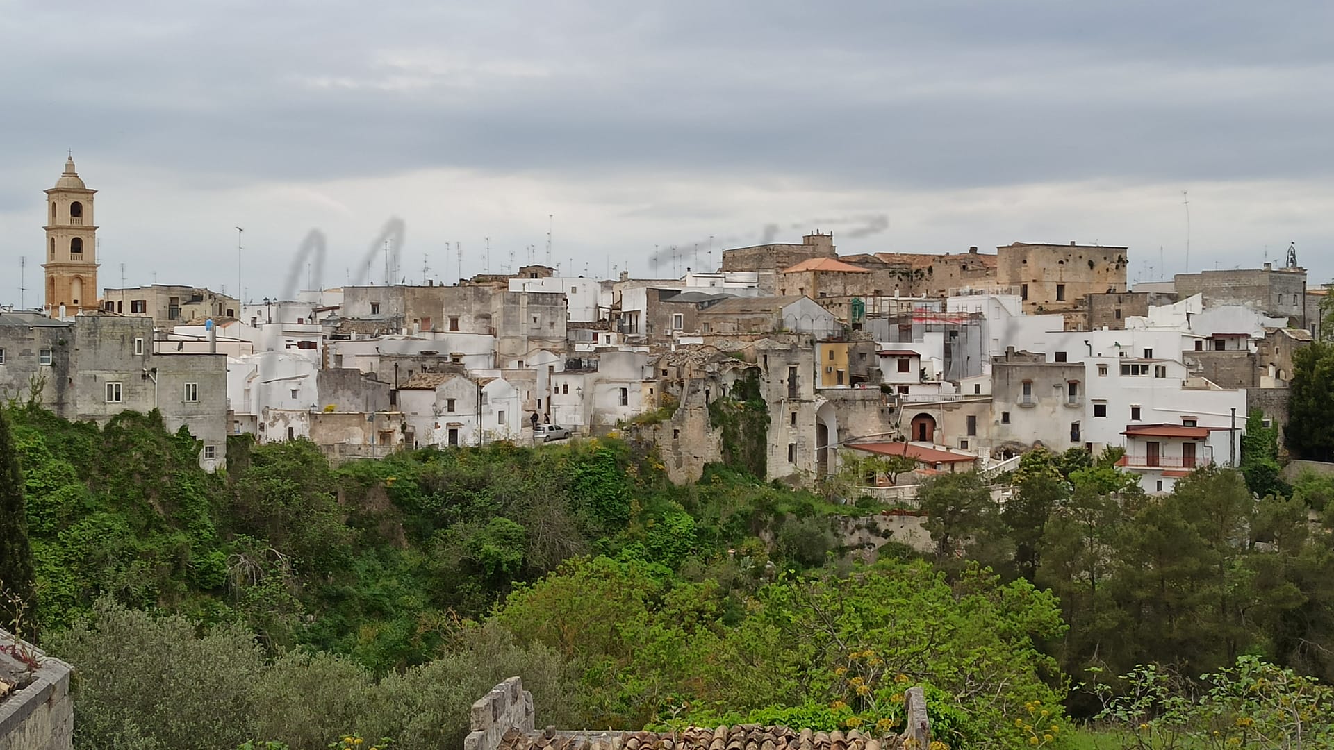
Laterza
Puglia
Historic town in Puglia with a large ravine, narrow streets, and local culinary specialties.
Quality of Life Score
[?]Factors in air quality, amenities, walkability, population, and environmental risks. Higher scores suggest better living conditions.
70
Quality of Infrastructure
[?]Measures internet speed, healthcare access, airports, rail, and walkability. Higher scores mean better connectivity and essential services.
62
Quality of Economy
[?]Based on income, property prices, job availability, and population density. Higher scores indicate stronger economic conditions.
63
Laterza Demographics
Population
[?]
This is a town's official population, measured each year by the national statistics authority.
14800
Real Population (5km band)
[?]
Our "Real Population" metric reflects more accurately a town's real size by including inhabitants in the immediate vicinity of the town's official borders.
37500
Births Per 100 Deaths
80.0
Population Data Source
ISTAT,2023
Estimated Unemployment Rate
Touristy Index
[?]
Calculation of tourist density index for the city, comparing its total tourist number to the overall average tourist number of the region
relative to its own population.The index indicates how a location’s tourist density compares to the average, with values above
100 representing higher-than-average density and values below 100 representing lower-than-average density.
Not Touristic
Income per capita (2023)
[?]
This is an estimation of average income per resident for this town, based on 2023 data from the Italian Ministry of Finance.
17000
Income rank in Italy (2023)
[?]
This is a ranking of the town's average income per resident, against the full list of townships in Italy.
5978 out of 7901
Infrastructure and Connectivity
Create an account to explore more
This content is for Members only | Already a Member? Sign in
Infrastructure & Amenities
Create an account to explore more
This content is for Members only | Already a Member? Sign in
Healthcare
Create an account to explore more
This content is for Members only | Already a Member? Sign in
Housing & Property Market
Create an account to explore more
This content is for Members only | Already a Member? Sign in
Connectivity & Digital Access
Create an account to explore more
This content is for Members only | Already a Member? Sign in
Education
Create an account to explore more
This content is for Members only | Already a Member? Sign in
Climate & Weather
Create an account to explore more
This content is for Members only | Already a Member? Sign in
Precipitation
[?] Based on daily climate data for precipitation from OPEN-METEO this parameter indicates how a city's annual precipitation compares to others in terms of percentage, with values ranging from 0 (lowest) to 1 (highest). For example, a percentile rank of 0.75 means the city's total precipitation is higher than 75% of other cities.
Very Low (Bottom 10%)
Sunshine
Very High (81st-90th percentile)
Snowfall
Low (11th-20th percentile)
Min Annual Temperature (°C)
[?] This parameter represents the monthly average of daily minimum temperatures for January, based on data from OPEN-METEO.
3.3
Max Annual Temperature (°C)
[?] This parameter represents the monthly average of daily minimum temperatures for January, based on data from OPEN-METEO.
31.8
Climate Description
Laterza, a town in Italy, offers a climate that couples moderate warmth with ample sunshine. Situated favorably, the town experiences mild, occasionally brisk winters with minimal snowfall, making it an attractive option for retirees and expats from colder regions. Summers are pleasantly warm, avoiding the scorching highs found in more southerly locations. The rainfall is relatively light and well-distributed throughout the year, allowing for lush landscapes without the discomfort of excessive wetness. Overall, Laterza enjoys a balanced climate that supports outdoor activities and leisure throughout the year, beneficial for those considering relocation to enjoy their golden years or seeking a magic-inspired locale.
Annual Temperature Chart (Min)
Error
There was a problem with your SQL connection - Please contact the administrator
There was a problem with your SQL connection - Please contact the administrator
Annual Temperature Chart (Max)
Error
There was a problem with your SQL connection - Please contact the administrator
There was a problem with your SQL connection - Please contact the administrator
Sunny Days By Month
Error
There was a problem with your SQL connection - Please contact the administrator
There was a problem with your SQL connection - Please contact the administrator
Environmental & Air Quality
Create an account to explore more
This content is for Members only | Already a Member? Sign in
Classifications
PM10
[?]
PM10 levels indicate Good air quality at 0–20 µg/m³, Fair at 20–40 µg/m³, Moderate at 40–50 µg/m³, Poor at 50–100 µg/m³, Very Poor at 100–150 µg/m³, and Extremely Poor at 150–1200 µg/m³.
Good
PM2.5
[?]
PM2.5 is Good if PM2.5 levels are between 0–10 µg/m³, Fair between 10–20 µg/m³, Moderate between 20–25 µg/m³, Poor between 25–50 µg/m³, Very Poor between 50–75 µg/m³, and Extremely Poor between 75–800 µg/m³.
Good
NO2
[?]
NO₂ levels are considered Good at 0–40 µg/m³, Fair at 40–90 µg/m³, Moderate at 90–120 µg/m³, Poor at 120–230 µg/m³, Very Poor at 230–340 µg/m³, and Extremely Poor at 340–1000 µg/m³.
Good
SO2
[?]
SO₂ levels indicate Good air quality at 0–100 µg/m³, Fair at 100–200 µg/m³, Moderate at 200–350 µg/m³, Poor at 350–500 µg/m³, Very Poor at 500–750 µg/m³, and Extremely Poor at 750–1250 µg/m³.
Good
O₃
[?]
For O₃, the air is Good at 0–50 µg/m³, Fair at 50–100 µg/m³, Moderate at 100–130 µg/m³, Poor at 130–240 µg/m³, Very Poor at 240–380 µg/m³, and Extremely Poor at 380–800 µg/m³.
Fair
Air Quality Rating
[?]
Based on PM10, PM2.5, NO2, SO2, and ozone levels. Higher scores indicate cleaner air.
90
Air Quality Description
In Laterza, Italy, the air quality generally presents a positive aspect that aligns with the expectations of both expatriates and retirees considering relocation. The particulate matter, notably PM10 and PM2.5, is well within acceptable levels, indicating a commendable degree of air cleanliness suitable for daily activities outside without concern. Furthermore, nitrogen and sulphur dioxide measures also reflect a favorable environmental condition, posing minimal impact on typical respiratory health. However, the town experiences moderate ozone levels, which, while not alarming, suggest that individuals with specific sensitivities should take heed during high ozone periods. Overall, Laterza offers a breathable atmosphere contributing positively to its living appeal.
In Laterza, Italy, the air quality generally presents a positive aspect that aligns with the expectations of both expatriates and retirees considering relocation. The particulate matter, notably PM10 and PM2.5, is well within acceptable levels, indicating a commendable degree of air cleanliness suitable for daily activities outside without concern. Furthermore, nitrogen and sulphur dioxide measures also reflect a favorable environmental condition, posing minimal impact on typical respiratory health. However, the town experiences moderate ozone levels, which, while not alarming, suggest that individuals with specific sensitivities should take heed during high ozone periods. Overall, Laterza offers a breathable atmosphere contributing positively to its living appeal.
Town Descriptions
Create an account to explore more
This content is for Members only | Already a Member? Sign in
Getting There
Laterza is accessible via the SS7 bis road, connecting it to major transportation networks. The nearest airports are Bari and Brindisi, while nearby train stations offer reasonable connectivity. Local infrastructure has been rated 62 out of 100, reflecting decent access to regional transport.
Getting Around
Local Cuisine
Laterza, a town in the Puglia region of Italy, is renowned for its exceptional culinary offerings, particularly its bread, a local tradition defined by its soft texture, achieved through a blend of durum and common wheat, baked in wood-burning ovens. The town is also celebrated for its vibrant wine culture and serves various local dishes, including Orecchiette pasta with broccoli rabe, alongside renowned cheeses such as burrata and caciocavallo. Dining options in Laterza range from traditional tavernas to modern eateries, reflecting both regional and international influences, yet no Michelin-starred restaurants are currently located in the town itself, with the closest notable establishments found in nearby areas within the region. This blend of tradition and contemporary dining makes Laterza a noteworthy destination within Puglia’s culinary landscape.
Shopping Overview
The shopping landscape features several categories including supermarkets, local boutiques, and dedicated shopping centres. Large shopping malls provide a range of brand options. Farmers markets offer fresh produce and regional goods, while flea markets serve as vibrant venues for unique finds. Specialty and gift shops are prevalent, catering to both locals and visitors. Additionally, factory outlets in the vicinity provide affordable access to various products. Overall, the shopping options are diverse, accommodating different tastes and needs.
Neighborhoods
Green Areas and Parks
Laterza offers notable outdoor activities anchored by its natural parks and trails. The Gravina di Laterza trail, set within the Terra delle Gravine Regional Natural Park, spans 6.3 miles and winds through a canyon rich with wildflowers and fauna. Another prominent route is the Via Ellenica – Terra delle Gravine, a segment of the Cammino Materano, covering 8.5 miles from Laterza to Ginosa. This path showcases canyons and olive groves, ultimately reaching the Murgia Pine Forest of San Pellegrino. These trails cater to hiking enthusiasts of moderate skill levels, offering direct exposure to Puglia’s diverse landscapes.
✅ Pros
– Rich cultural and historical heritage to explore and enjoy.
– Good air quality contributes to a healthy lifestyle.
– Less touristy, offering a more authentic Italian experience.
– Affordable cost of living compared to larger cities.
– Opportunities for local integration and community involvement.
– Mild climate ideal for year-round outdoor activities.
– Access to quality local healthcare services.
– Decent transportation infrastructure for regional travel.
– Peaceful environment, perfect for retirement or relaxation.
– Growing digital connectivity for remote work opportunities.
❌ Cons
– Limited healthcare options compared to larger urban centers.
– Transportation may not always be reliable or frequent.
– Job market is quite competitive with higher unemployment rates.
– Income levels can be lower than in other regions.
– Internet speeds may not be sufficient for heavy users.
– Limited cultural events and activities throughout the year.
– Fewer educational facilities for those with children.
– More bureaucracy in local administration might be frustrating.
– Language barrier could hinder integration for non-Italian speakers.
– Local cuisine may not suit every palate or preference.
FAQs
Summary
Laterza, located in the Puglia region, blends rich history with a vibrant local culture, appealing to expats and retirees alike. This town features a remarkable ravine, one of the largest in Europe, providing a backdrop for outdoor excursions and nature walks. Its old town, characterized by narrow streets and charming squares, is home to numerous historical sites, including the 11th-century Minor Church and the Palazzo Marchesale. The local specialty, ‘Pane di Laterza’, is a must-try, reflective of the region’s culinary traditions.
Despite its allure, Laterza may present challenges such as limited access to major urban amenities, with the nearest beach approximately 37 km away and healthcare services rated comparatively lower. The dynamic local life, however, is enriched by traditions and a strong sense of community, making it an attractive destination for those seeking a quieter lifestyle amidst the stunning landscapes of southern Italy.
✅ Pros
– Rich cultural and historical heritage to explore and enjoy.
– Good air quality contributes to a healthy lifestyle.
– Less touristy, offering a more authentic Italian experience.
– Affordable cost of living compared to larger cities.
– Opportunities for local integration and community involvement.
– Mild climate ideal for year-round outdoor activities.
– Access to quality local healthcare services.
– Decent transportation infrastructure for regional travel.
– Peaceful environment, perfect for retirement or relaxation.
– Growing digital connectivity for remote work opportunities.
❌ Cons
– Limited healthcare options compared to larger urban centers.
– Transportation may not always be reliable or frequent.
– Job market is quite competitive with higher unemployment rates.
– Income levels can be lower than in other regions.
– Internet speeds may not be sufficient for heavy users.
– Limited cultural events and activities throughout the year.
– Fewer educational facilities for those with children.
– More bureaucracy in local administration might be frustrating.
– Language barrier could hinder integration for non-Italian speakers.
– Local cuisine may not suit every palate or preference.
Related Posts
No posts found for the town.
More questions about Laterza ? Ask Magic AI.
Our innovative AI assistant is eager to help. Try it out for free here: