
Elevation
[?]
Elevation of a city refers to the height above sea level at which the city is located, measured in meters.
129
Population
[?]
This is a town's official population, measured each year by the national statistics authority.
10900
Real Population (5km)
[?]
Our "Real Population" metric reflects more accurately a town's real size by including inhabitants in the immediate vicinity of the town's official borders.
42500
Air Quality Rating
[?]
Based on PM10, PM2.5, NO2, SO2, and ozone levels. Higher scores indicate cleaner air.
84
Region
Sardegna
Walkability
Very Walkable
Housing availability
[?]
Based on total number of properties (sale and rent) classifies housing availability into five categories: low, relativel ylow, medium, relatively high and high.
Low
Avg Download Speed (Mbps) / Avg Upload Speed (Mbps)
72
/ 17
Climate Description
Mild climate, no snow, warm summers, gentle winters, ample sun, moderate and even rainfall.
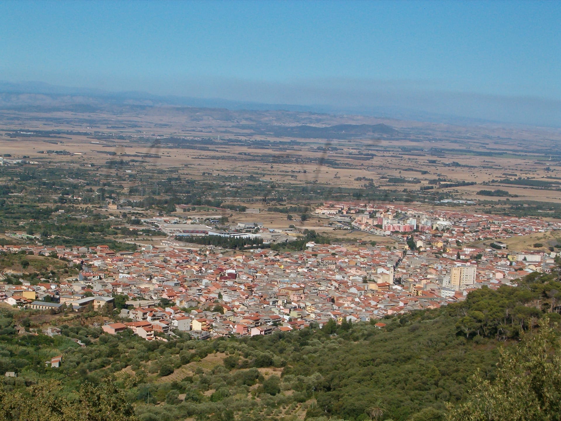
Guspini
Sardegna
Historic town in Sardinia with a mix of cultural activities, agriculture, and mining industries.
Quality of Life Score
[?]Factors in air quality, amenities, walkability, population, and environmental risks. Higher scores suggest better living conditions.
74
Quality of Infrastructure
[?]Measures internet speed, healthcare access, airports, rail, and walkability. Higher scores mean better connectivity and essential services.
56
Quality of Economy
[?]Based on income, property prices, job availability, and population density. Higher scores indicate stronger economic conditions.
63
Guspini Demographics
Population
[?]
This is a town's official population, measured each year by the national statistics authority.
10900
Real Population (5km band)
[?]
Our "Real Population" metric reflects more accurately a town's real size by including inhabitants in the immediate vicinity of the town's official borders.
42500
Births Per 100 Deaths
30.0
Population Data Source
ISTAT,2023
Estimated Unemployment Rate
Touristy Index
[?]
Calculation of tourist density index for the city, comparing its total tourist number to the overall average tourist number of the region
relative to its own population.The index indicates how a location’s tourist density compares to the average, with values above
100 representing higher-than-average density and values below 100 representing lower-than-average density.
Not Touristic
Income per capita (2023)
[?]
This is an estimation of average income per resident for this town, based on 2023 data from the Italian Ministry of Finance.
18000
Income rank in Italy (2023)
[?]
This is a ranking of the town's average income per resident, against the full list of townships in Italy.
5433 out of 7901
Infrastructure and Connectivity
Create an account to explore more
This content is for Members only | Already a Member? Sign in
Infrastructure & Amenities
Create an account to explore more
This content is for Members only | Already a Member? Sign in
Healthcare
Create an account to explore more
This content is for Members only | Already a Member? Sign in
Housing & Property Market
Create an account to explore more
This content is for Members only | Already a Member? Sign in
Connectivity & Digital Access
Create an account to explore more
This content is for Members only | Already a Member? Sign in
Education
Create an account to explore more
This content is for Members only | Already a Member? Sign in
Climate & Weather
Create an account to explore more
This content is for Members only | Already a Member? Sign in
Precipitation
[?] Based on daily climate data for precipitation from OPEN-METEO this parameter indicates how a city's annual precipitation compares to others in terms of percentage, with values ranging from 0 (lowest) to 1 (highest). For example, a percentile rank of 0.75 means the city's total precipitation is higher than 75% of other cities.
Very Low (Bottom 10%)
Sunshine
Very High (81st-90th percentile)
Snowfall
Very Low (Bottom 10%)
Min Annual Temperature (°C)
[?] This parameter represents the monthly average of daily minimum temperatures for January, based on data from OPEN-METEO.
6.7
Max Annual Temperature (°C)
[?] This parameter represents the monthly average of daily minimum temperatures for January, based on data from OPEN-METEO.
30.6
Climate Description
Guspini's climate is characterized by mild temperatures and a pronounced lack of snow, reflecting its Mediterranean setting. Summers in Guspini are notably warm, often reaching the peak of warmth, while winters are gentle and free from frosty extremes. The region enjoys an ample amount of sunlight throughout the year, ensuring that days are predominantly bright and clear. Precipitation is moderate, with rainfall distributed evenly across the seasons, preserving the natural greenery and agricultural vitality of the area. This balanced climate makes Guspini an appealing destination for expatriates and retirees seeking a stable and accommodating weather pattern.
Annual Temperature Chart (Min)
Error
There was a problem with your SQL connection - Please contact the administrator
There was a problem with your SQL connection - Please contact the administrator
Annual Temperature Chart (Max)
Error
There was a problem with your SQL connection - Please contact the administrator
There was a problem with your SQL connection - Please contact the administrator
Sunny Days By Month
Error
There was a problem with your SQL connection - Please contact the administrator
There was a problem with your SQL connection - Please contact the administrator
Environmental & Air Quality
Create an account to explore more
This content is for Members only | Already a Member? Sign in
Classifications
PM10
[?]
PM10 levels indicate Good air quality at 0–20 µg/m³, Fair at 20–40 µg/m³, Moderate at 40–50 µg/m³, Poor at 50–100 µg/m³, Very Poor at 100–150 µg/m³, and Extremely Poor at 150–1200 µg/m³.
Good
PM2.5
[?]
PM2.5 is Good if PM2.5 levels are between 0–10 µg/m³, Fair between 10–20 µg/m³, Moderate between 20–25 µg/m³, Poor between 25–50 µg/m³, Very Poor between 50–75 µg/m³, and Extremely Poor between 75–800 µg/m³.
Good
NO2
[?]
NO₂ levels are considered Good at 0–40 µg/m³, Fair at 40–90 µg/m³, Moderate at 90–120 µg/m³, Poor at 120–230 µg/m³, Very Poor at 230–340 µg/m³, and Extremely Poor at 340–1000 µg/m³.
Good
SO2
[?]
SO₂ levels indicate Good air quality at 0–100 µg/m³, Fair at 100–200 µg/m³, Moderate at 200–350 µg/m³, Poor at 350–500 µg/m³, Very Poor at 500–750 µg/m³, and Extremely Poor at 750–1250 µg/m³.
Good
O₃
[?]
For O₃, the air is Good at 0–50 µg/m³, Fair at 50–100 µg/m³, Moderate at 100–130 µg/m³, Poor at 130–240 µg/m³, Very Poor at 240–380 µg/m³, and Extremely Poor at 380–800 µg/m³.
Fair
Air Quality Rating
[?]
Based on PM10, PM2.5, NO2, SO2, and ozone levels. Higher scores indicate cleaner air.
84
Air Quality Description
Guspini, nestled in the heart of Italy, offers a promising environment in terms of air quality that expats and retirees would appreciate. Sampling reveals commendable levels of particulate matter; both larger (PM10) and finer particles (PM2.5) are well within safe limits, classified as ‘Good.’ Similarly, nitrogen and sulfur dioxide levels are notably low, reflecting conscientious management and a lesser burden of industrial pollutants. Ozone levels, slightly higher, receive a ‘Fair’ classification, indicating moderate exposure. Overall, Guspini presents a relatively clean air profile conducive to those looking for a healthier lifestyle adaptation.
Guspini, nestled in the heart of Italy, offers a promising environment in terms of air quality that expats and retirees would appreciate. Sampling reveals commendable levels of particulate matter; both larger (PM10) and finer particles (PM2.5) are well within safe limits, classified as ‘Good.’ Similarly, nitrogen and sulfur dioxide levels are notably low, reflecting conscientious management and a lesser burden of industrial pollutants. Ozone levels, slightly higher, receive a ‘Fair’ classification, indicating moderate exposure. Overall, Guspini presents a relatively clean air profile conducive to those looking for a healthier lifestyle adaptation.
Town Descriptions
Create an account to explore more
This content is for Members only | Already a Member? Sign in
Getting There
Guspini is accessible primarily via the SS131 road, which connects it to major cities in Sardinia. The nearest key airports are Cagliari Elmas and Alghero Fertilia, while local train stations offer varying degrees of connectivity. Overall, the town’s infrastructure is moderately rated.
Getting Around
Local Cuisine
The culinary scene in Guspini, Sardegna, is deeply rooted in traditional Sardinian cuisine, showcasing local specialties such as Culurgiones (dumplings), Malloreddus (gnocchi), and Fregola (couscous). The region also prides itself on its seafood, with dishes featuring octopus and shrimp, and iconic local products like Pecorino Sardo cheese and Pane Carasau bread. Dining options range from traditional Italian eateries serving typical Sardinian dishes to establishments that may incorporate international influences. However, there are currently no Michelin-starred restaurants in Guspini, reflecting a local yet robust dining landscape that emphasizes regional cuisine.
Shopping Overview
The area offers a range of shopping options, including various supermarkets and shopping centres. Key formats include grocery stores, larger shopping arenas, and local boutiques. Supermarkets provide essentials and local products. Shopping centres feature a collection of outlets, from grocery to specialty shops. There are larger retail venues attracting diverse clientele, facilitating both everyday shopping and special purchases. The shopping environment caters well to expats and retirees seeking convenience and variety in their retail experiences.
Neighborhoods
Green Areas and Parks
Guspini, in Sardegna, offers a variety of outdoor activities and trails, ideal for retirees and outdoor enthusiasts. Notable trails include Monte Santa Margherita and Sa Rocca Incuaddigada, suitable for hiking. The area also features paths like Guspini – Su Montixeddu – Genna ‘e Frongia – Su Mori de Luziferu. These trails traverse diverse landscapes, providing opportunities for leisurely walks or more challenging hikes. Outdoor activities are complemented by the nearby Montevecchio, historically significant for its mining past, adding cultural interest to recreational pursuits.
✅ Pros
– Mild Mediterranean climate with warm summers and mild winters.
– Rich cultural and historical heritage to explore and enjoy.
– Opportunities for integration within the local community.
– Quality healthcare services available for residents.
– Air quality is generally good and beneficial for health.
– Less touristy, providing a quieter lifestyle and local charm.
– Reasonable infrastructure supporting daily needs and transportation.
– Scenic natural surroundings ideal for outdoor activities.
– Affordable cost of living compared to larger Italian cities.
– Strong sense of community among residents and locals.
❌ Cons
– Limited healthcare score may raise concerns for some residents.
– Employment opportunities are fewer than in larger cities.
– Infrastructure score suggests occasional transport and service shortcomings.
– Internet speeds may frustrate heavy users or remote workers.
– Limited educational facilities for families with school-aged children.
– Quiet lifestyle may feel isolating for some expats.
– Local shops may have less variety than urban centers.
– Language barrier could complicate integration for non-Italian speakers.
– Unemployment rate higher than the national average.
– Cultural activities may be fewer compared to tourist-heavy areas.
FAQs
Summary
Guspini, nestled in the heart of Sardinia, offers expats a compelling blend of historical richness and vibrant local life. This town, renowned for its proximity to significant archaeological sites like the Miniera di Montevecchio and the Chiesa di San Nicolo, is not just a gateway to Sardinia’s past but also a hub of cultural activities. Local industries, especially agriculture and mining, shape its economy, providing residents with a taste of traditional Sardinian life.
However, potential expats should be mindful of some challenges. Guspini’s job market can be limiting, often skewed towards lower-wage opportunities, and locals report bureaucratic hurdles that can complicate residency processes. Despite these drawbacks, the town boasts excellent air quality and is just a short drive from stunning beaches, making it an attractive choice for retirees seeking a quiet Mediterranean lifestyle amidst a tight-knit community.
✅ Pros
– Mild Mediterranean climate with warm summers and mild winters.
– Rich cultural and historical heritage to explore and enjoy.
– Opportunities for integration within the local community.
– Quality healthcare services available for residents.
– Air quality is generally good and beneficial for health.
– Less touristy, providing a quieter lifestyle and local charm.
– Reasonable infrastructure supporting daily needs and transportation.
– Scenic natural surroundings ideal for outdoor activities.
– Affordable cost of living compared to larger Italian cities.
– Strong sense of community among residents and locals.
❌ Cons
– Limited healthcare score may raise concerns for some residents.
– Employment opportunities are fewer than in larger cities.
– Infrastructure score suggests occasional transport and service shortcomings.
– Internet speeds may frustrate heavy users or remote workers.
– Limited educational facilities for families with school-aged children.
– Quiet lifestyle may feel isolating for some expats.
– Local shops may have less variety than urban centers.
– Language barrier could complicate integration for non-Italian speakers.
– Unemployment rate higher than the national average.
– Cultural activities may be fewer compared to tourist-heavy areas.
Related Posts
No posts found for the town.
More questions about Guspini ? Ask Magic AI.
Our innovative AI assistant is eager to help. Try it out for free here: