
Elevation
[?]
Elevation of a city refers to the height above sea level at which the city is located, measured in meters.
232
Population
[?]
This is a town's official population, measured each year by the national statistics authority.
11300
Real Population (5km)
[?]
Our "Real Population" metric reflects more accurately a town's real size by including inhabitants in the immediate vicinity of the town's official borders.
104200
Air Quality Rating
[?]
Based on PM10, PM2.5, NO2, SO2, and ozone levels. Higher scores indicate cleaner air.
86
Region
Lombardia
Walkability
Very Walkable
Housing availability
[?]
Based on total number of properties (sale and rent) classifies housing availability into five categories: low, relativel ylow, medium, relatively high and high.
Low
Avg Download Speed (Mbps) / Avg Upload Speed (Mbps)
226
/ 147
Climate Description
Balanced climate: modest snowfall, warm summers, ample rainfall, plentiful sunshine.
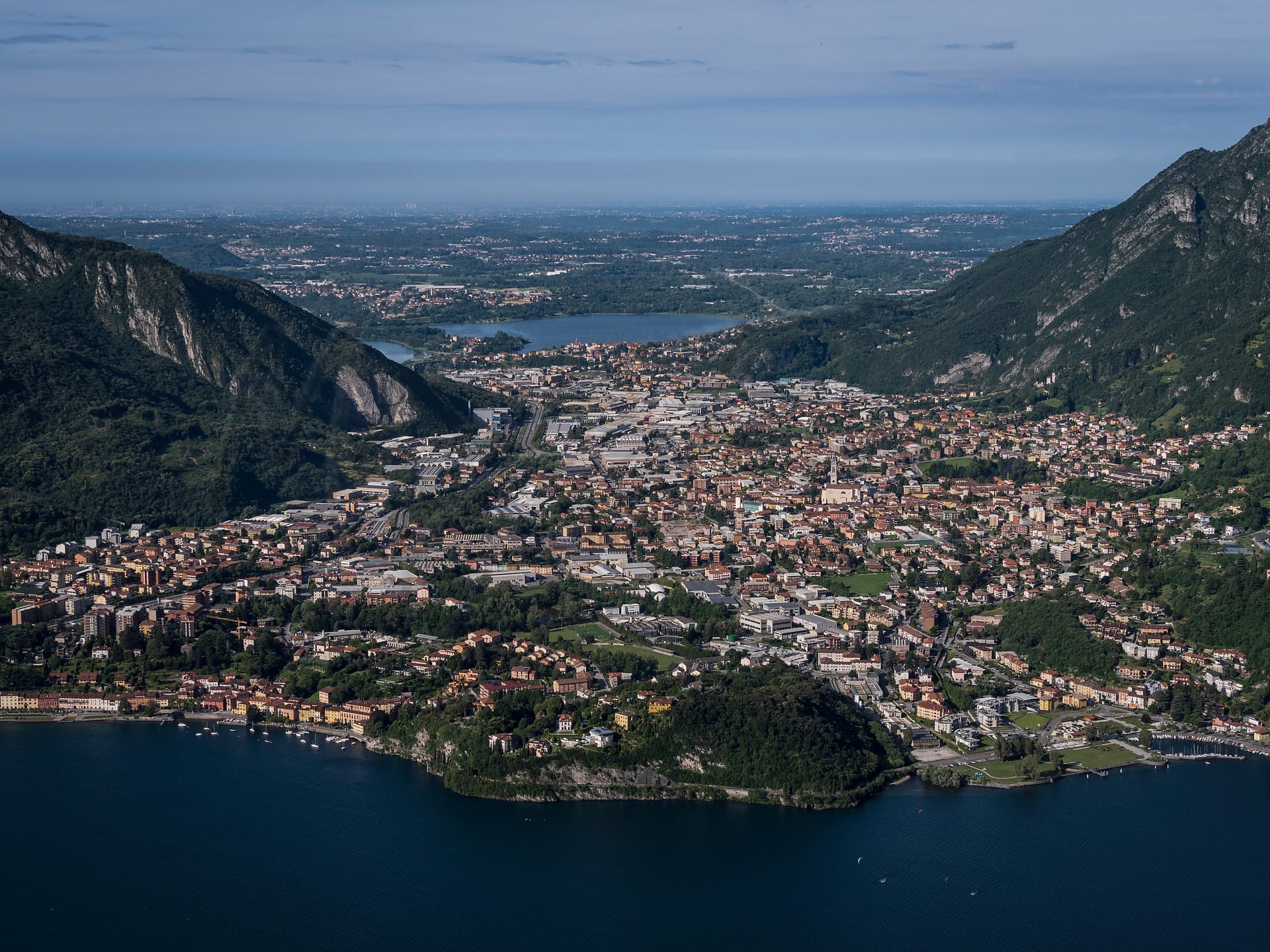
Valmadrera
Lombardia
Historic town by Lake Como with a textile-focused economy and strong community traditions.
Quality of Life Score
[?]Factors in air quality, amenities, walkability, population, and environmental risks. Higher scores suggest better living conditions.
73
Quality of Infrastructure
[?]Measures internet speed, healthcare access, airports, rail, and walkability. Higher scores mean better connectivity and essential services.
68
Quality of Economy
[?]Based on income, property prices, job availability, and population density. Higher scores indicate stronger economic conditions.
74
Valmadrera Demographics
Population
[?]
This is a town's official population, measured each year by the national statistics authority.
11300
Real Population (5km band)
[?]
Our "Real Population" metric reflects more accurately a town's real size by including inhabitants in the immediate vicinity of the town's official borders.
104200
Births Per 100 Deaths
80.0
Population Data Source
ISTAT,2023
Estimated Unemployment Rate
Touristy Index
[?]
Calculation of tourist density index for the city, comparing its total tourist number to the overall average tourist number of the region
relative to its own population.The index indicates how a location’s tourist density compares to the average, with values above
100 representing higher-than-average density and values below 100 representing lower-than-average density.
Not Touristic
Income per capita (2023)
[?]
This is an estimation of average income per resident for this town, based on 2023 data from the Italian Ministry of Finance.
24400
Income rank in Italy (2023)
[?]
This is a ranking of the town's average income per resident, against the full list of townships in Italy.
744 out of 7901
Infrastructure and Connectivity
Create an account to explore more
This content is for Members only | Already a Member? Sign in
Closest Airport
Name
Linate (Milan)
Connectivity Score
[?]
Measures travel time and service quality of nearby airport stations. Higher scores mean better transport access.
7
Driving Time
43min(s)
Milan Linate Airport (LIN), situated in Segrate and Peschiera Borromeo in Lombardy, Italy, serves around 10.6 million passengers annually. It focuses on flights within Europe and the United Kingdom, serving as a hub for ITA Airways. The airport offers convenient connections to popular destinations such as Rome, Cagliari, and Paris, making it an accessible choice for travellers seeking direct European flights.
2nd Closest Airport
Name
Malpensa (Milan)
Connectivity Score
[?]
Measures travel time and service quality of nearby airport stations. Higher scores mean better transport access.
10
Driving Time
52min(s)
Milan Malpensa Airport (MXP) is located near Milan, Italy, and is the second largest and busiest airport in the country. Handling 28.5 million passengers, the airport connects to around 195 destinations worldwide, serving as a major hub for EasyJet. Key routes include flights to New York, London, Dubai, and Istanbul, making it a significant international gateway. Notable for its effective connectivity with Milan’s city centre via the Malpensa Express, the airport caters extensively to travellers heading to diverse European, American, and Asian destinations.
3rd Closest Airport
Name
Orio al Serio (Bergamo)
Connectivity Score
[?]
Measures travel time and service quality of nearby airport stations. Higher scores mean better transport access.
7
Driving Time
52min(s)
Orio al Serio International Airport, also known as Milan Bergamo Airport, is located just 5 km from Bergamo and about 45 km from Milan in Lombardy, Italy. It is the third busiest airport in Italy, serving over 13 million passengers annually and acting as a major hub for Ryanair. The airport connects to numerous European destinations including Copenhagen, Düsseldorf, as well as farther routes like Dubai and Cairo. Known for its budget-friendly flights primarily operated by Ryanair, Milan Bergamo Airport is a popular choice for travellers looking for affordable options to various international destinations.
Closest Rail
Name
Stazione di Valmadrera
Connectivity Score
[?]
Measures travel time and service quality of nearby rail stations. Higher scores mean better transport access.
7
Driving Time
7min(s)
Train service at Stazione di Valmadrera includes multiple rail lines primarily operated by Trenord. The key lines serving the station are the Como–Lecco railway, which facilitates connections to the Milan Metropolitan services (S7) travelling from Milan to Molteno and Lecco, and the Lombardy Regional services (R18) operating between Como and Molteno and Lecco.
Direct train destinations include major towns and cities such as Milan, Lecco, and Como.
Trenord is the main train operator servicing this station, particularly focusing on regional connections. Departures from the station are generally frequent, with trains running approximately every 30 minutes, ensuring convenient travel for passengers.
The services at Stazione di Valmadrera mainly consist of regional trains, with no high-speed train services currently available.
2nd Closest Rail
Name
Stazione di Lecco
Connectivity Score
[?]
Measures travel time and service quality of nearby rail stations. Higher scores mean better transport access.
8
Driving Time
14min(s)
Train service at Stazione di Lecco provides connections via five main rail lines: Bergamo, Como, Milan, Molteno/Monza, and Tirano. Key destinations connected by direct trains include Milano Centrale, Como, Bergamo, Sondrio, and Tirano. Services are operated predominantly by Trenord, with approximately 154 trains calling at the station daily. Departures occur hourly, especially for regional services. Stazione di Lecco primarily offers regional train services, though it connects with the Milan suburban railway, providing a mix of regional and some express options.
3rd Closest Rail
Name
Stazione di Lecco Maggianico
Connectivity Score
[?]
Measures travel time and service quality of nearby rail stations. Higher scores mean better transport access.
6
Driving Time
15min(s)
Train service at Stazione di Lecco Maggianico is primarily provided by the S8 line of the Milan suburban railway service, operated by Trenord. Key destinations connected by direct trains include Milan and Lecco, with regular services catering to commuters and local travellers. Departures occur at a frequency of approximately every 30 minutes during peak times, making it a convenient option for daily travel. The station is primarily served by regional trains, with no high-speed trains stopping at this location.
Infrastructure & Amenities
Create an account to explore more
This content is for Members only | Already a Member? Sign in
Healthcare
Create an account to explore more
This content is for Members only | Already a Member? Sign in
Housing & Property Market
Create an account to explore more
This content is for Members only | Already a Member? Sign in
Connectivity & Digital Access
Create an account to explore more
This content is for Members only | Already a Member? Sign in
Education
Create an account to explore more
This content is for Members only | Already a Member? Sign in
Climate & Weather
Create an account to explore more
This content is for Members only | Already a Member? Sign in
Precipitation
[?] Based on daily climate data for precipitation from OPEN-METEO this parameter indicates how a city's annual precipitation compares to others in terms of percentage, with values ranging from 0 (lowest) to 1 (highest). For example, a percentile rank of 0.75 means the city's total precipitation is higher than 75% of other cities.
Very High (81st-90th percentile)
Sunshine
Low (11th-20th percentile)
Snowfall
Somewhat High (61st-70th percentile)
Min Annual Temperature (°C)
[?] This parameter represents the monthly average of daily minimum temperatures for January, based on data from OPEN-METEO.
-0.3
Max Annual Temperature (°C)
[?] This parameter represents the monthly average of daily minimum temperatures for January, based on data from OPEN-METEO.
27.4
Climate Description
Valmadrera, Italy, provides a balanced climate that supports a diverse range of activities throughout the year. Winters bring modest snowfall, creating a picturesque setting without severe disruptions often associated with heavier snow. Summers are pleasantly warm, allowing for enjoyable outdoor pursuits from hiking to lake activities. The area receives ample rainfall, ensuring lush, verdant landscapes and contributing to the local flora's vitality. Sunshine is plentiful, ensuring that even the cooler seasons have their fair share of bright days. As such, Valmadrera's weather is conducive to a comfortable lifestyle for expats and retirees seeking a temperate European climate.
Annual Temperature Chart (Min)
Error
There was a problem with your SQL connection - Please contact the administrator
There was a problem with your SQL connection - Please contact the administrator
Annual Temperature Chart (Max)
Error
There was a problem with your SQL connection - Please contact the administrator
There was a problem with your SQL connection - Please contact the administrator
Sunny Days By Month
Error
There was a problem with your SQL connection - Please contact the administrator
There was a problem with your SQL connection - Please contact the administrator
Environmental & Air Quality
Create an account to explore more
This content is for Members only | Already a Member? Sign in
Classifications
PM10
[?]
PM10 levels indicate Good air quality at 0–20 µg/m³, Fair at 20–40 µg/m³, Moderate at 40–50 µg/m³, Poor at 50–100 µg/m³, Very Poor at 100–150 µg/m³, and Extremely Poor at 150–1200 µg/m³.
Fair
PM2.5
[?]
PM2.5 is Good if PM2.5 levels are between 0–10 µg/m³, Fair between 10–20 µg/m³, Moderate between 20–25 µg/m³, Poor between 25–50 µg/m³, Very Poor between 50–75 µg/m³, and Extremely Poor between 75–800 µg/m³.
Fair
NO2
[?]
NO₂ levels are considered Good at 0–40 µg/m³, Fair at 40–90 µg/m³, Moderate at 90–120 µg/m³, Poor at 120–230 µg/m³, Very Poor at 230–340 µg/m³, and Extremely Poor at 340–1000 µg/m³.
Good
SO2
[?]
SO₂ levels indicate Good air quality at 0–100 µg/m³, Fair at 100–200 µg/m³, Moderate at 200–350 µg/m³, Poor at 350–500 µg/m³, Very Poor at 500–750 µg/m³, and Extremely Poor at 750–1250 µg/m³.
Good
O₃
[?]
For O₃, the air is Good at 0–50 µg/m³, Fair at 50–100 µg/m³, Moderate at 100–130 µg/m³, Poor at 130–240 µg/m³, Very Poor at 240–380 µg/m³, and Extremely Poor at 380–800 µg/m³.
Fair
Air Quality Rating
[?]
Based on PM10, PM2.5, NO2, SO2, and ozone levels. Higher scores indicate cleaner air.
86
Air Quality Description
Valmadrera, a picturesque town in Italy, boasts air quality that generally aligns with expectations for smaller European locales. In this region, particulate matter and ozone levels are fair, supporting a comfortable environment for everyday activities. This includes finer particles typically found in urban areas, which are also present at moderate levels. Additionally, the town presents low concentrations of nitrogen and sulfur oxides, indicators of cleaner combustion and less industrial pollution. Such conditions are conducive to retirees and expats looking for a quaint setting that balances pastoral charms with a decent urban living standard without the encumbrances of dense pollution.
Valmadrera, a picturesque town in Italy, boasts air quality that generally aligns with expectations for smaller European locales. In this region, particulate matter and ozone levels are fair, supporting a comfortable environment for everyday activities. This includes finer particles typically found in urban areas, which are also present at moderate levels. Additionally, the town presents low concentrations of nitrogen and sulfur oxides, indicators of cleaner combustion and less industrial pollution. Such conditions are conducive to retirees and expats looking for a quaint setting that balances pastoral charms with a decent urban living standard without the encumbrances of dense pollution.
Town Descriptions
Create an account to explore more
This content is for Members only | Already a Member? Sign in
Getting There
Valmadrera is well-positioned for transport connectivity, with nearby road access via the SS36, facilitating connections to major urban centers. The town’s proximity to Linate and Malpensa airports enhances its accessibility. Local train stations, within a short distance, provide further regional links, contributing to a favorable infrastructure rating.
Getting Around
Local Cuisine
Valmadrera, located in the Lombardy region of Italy, boasts a rich culinary scene deeply rooted in traditional Lombard cuisine. Key dishes include Risotto alla Milanese, Cotoletta alla Milanese, and hearty preparations of polenta, which are staples of the local diet. The use of butter, a variety of cheeses, and robust meat dishes characterize the local gastronomy. Restaurants in Valmadrera showcase this traditional fare alongside various international dining options, reflecting a growing globalization of tastes. Among notable international influences are offerings like Persian and diverse Italian pizzerias. The town also features a Michelin-starred establishment, Villa Giulia – Al Terrazzo, which is recognized for its fine Italian cuisine. Therefore, Valmadrera not only preserves its cultural culinary heritage but also embraces a variety of flavors from around the world, catering to diverse palates and dining preferences.
Shopping Overview
The area features a variety of shopping options suitable for residents and visitors. Key categories include supermarkets, local flea markets, and specialty shops, offering both everyday essentials and unique items. Additionally, large shopping centres nearby provide an expansive retail experience, housing numerous franchises and boutiques. This mix allows for diverse shopping experiences from practical necessities to leisure browsing, making the region accessible for a wide demographic, including expats and retirees.
Neighborhoods
Green Areas and Parks
Valmadrera, located in Lombardia, offers several verifiable outdoor activities suitable for expats and retirees. The San Tomaso da Valmadrera path is a notable hiking route, featuring a loop tour of 3.96 kilometers with varied difficulty levels, suitable for both intermediate and expert hikers. Another prominent trail, Sentiero delle Vasche, is known for its immersive natural scenery. Additionally, the town provides access to the loop hike of Pian Sciresa and Monte Barro, spanning 8.23 kilometers. These outdoor options highlight Valmadrera’s appeal for nature enthusiasts seeking activities within accessible distances.
✅ Pros
– Excellent air quality for outdoor activities and health benefits.
– Low unemployment rate indicates a stable local economy.
– Good transportation links to nearby cities and regions.
– Rich cultural and historical backdrop for exploration and enjoyment.
– Opportunities for social integration within the local community.
– Quality healthcare facilities available for residents.
– Mild climate suitable for year-round outdoor activities.
– Less touristy environment fosters a peaceful living experience.
– Adequate internet connectivity for remote work and communication.
– Affordable cost of living compared to larger Italian cities.
❌ Cons
– Limited healthcare quality may lead to longer wait times.
– Infrastructure improvements needed for optimal convenience and access.
– Internet speeds, while adequate, may not satisfy heavy users.
– Mild climate can occasionally lead to damp, chilly winters.
– Lack of tourist attractions may lead to boredom over time.
– Limited educational options for families with school-aged children.
– The small town might feel isolating for some residents.
– Local events may not cater to diverse international tastes.
– Language barrier could hinder deeper community integration.
– Few entertainment options compared to larger neighboring cities.
FAQs
Summary
Valmadrera, a charming town located along the shores of Lake Como near Lecco, offers a blend of historical significance and modern living, making it an appealing option for foreign expats and retirees. With roots tracing back to Roman times, the town features a rich tapestry of influences from prominent local families visible in its architecture. Valmadrera’s economy is primarily centered on the textile industry, reflecting its industrial heritage. Key attractions include the scenic lakeside, historical churches, and the annual feast of St. Antonio Abate, which showcases local traditions and community spirit.
Valmadrera’s walkable layout, supported by an admirable accessibility score, fosters a sense of community, while the proximity to both urban conveniences and natural beauty enhances its allure. However, the reliance on localized industries may present limited job opportunities for newcomers, making adaptability essential. Overall, Valmadrera strikes a balance between cultural richness and the potential challenges of integration.
✅ Pros
– Excellent air quality for outdoor activities and health benefits.
– Low unemployment rate indicates a stable local economy.
– Good transportation links to nearby cities and regions.
– Rich cultural and historical backdrop for exploration and enjoyment.
– Opportunities for social integration within the local community.
– Quality healthcare facilities available for residents.
– Mild climate suitable for year-round outdoor activities.
– Less touristy environment fosters a peaceful living experience.
– Adequate internet connectivity for remote work and communication.
– Affordable cost of living compared to larger Italian cities.
❌ Cons
– Limited healthcare quality may lead to longer wait times.
– Infrastructure improvements needed for optimal convenience and access.
– Internet speeds, while adequate, may not satisfy heavy users.
– Mild climate can occasionally lead to damp, chilly winters.
– Lack of tourist attractions may lead to boredom over time.
– Limited educational options for families with school-aged children.
– The small town might feel isolating for some residents.
– Local events may not cater to diverse international tastes.
– Language barrier could hinder deeper community integration.
– Few entertainment options compared to larger neighboring cities.
Related Posts
No posts found for the town.
More questions about Valmadrera ? Ask Magic AI.
Our innovative AI assistant is eager to help. Try it out here: