
Elevation
[?]
Elevation of a city refers to the height above sea level at which the city is located, measured in meters.
392
Population
[?]
This is a town's official population, measured each year by the national statistics authority.
15600
Real Population (5km)
[?]
Our "Real Population" metric reflects more accurately a town's real size by including inhabitants in the immediate vicinity of the town's official borders.
47600
Air Quality Rating
[?]
Based on PM10, PM2.5, NO2, SO2, and ozone levels. Higher scores indicate cleaner air.
96
Region
Umbria
Walkability
Very Walkable
Housing availability
[?]
Based on total number of properties (sale and rent) classifies housing availability into five categories: low, relativel ylow, medium, relatively high and high.
Relatively High
Avg Download Speed (Mbps) / Avg Upload Speed (Mbps)
41
/ 10
Climate Description
Balanced climate, mild winters, warm summers, moderate rain, lush landscapes year-round.
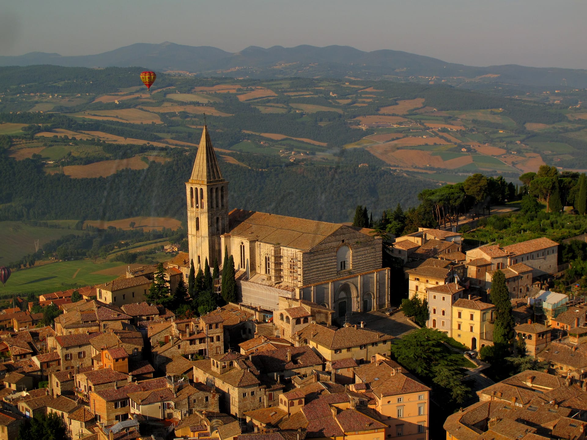
Todi
Umbria
Historic town in Umbria known for medieval architecture, walkability, and cultural heritage.
Quality of Life Score
[?]Factors in air quality, amenities, walkability, population, and environmental risks. Higher scores suggest better living conditions.
66
Quality of Infrastructure
[?]Measures internet speed, healthcare access, airports, rail, and walkability. Higher scores mean better connectivity and essential services.
49
Quality of Economy
[?]Based on income, property prices, job availability, and population density. Higher scores indicate stronger economic conditions.
78
Todi Demographics
Population
[?]
This is a town's official population, measured each year by the national statistics authority.
15600
Real Population (5km band)
[?]
Our "Real Population" metric reflects more accurately a town's real size by including inhabitants in the immediate vicinity of the town's official borders.
47600
Births Per 100 Deaths
40.0
Population Data Source
ISTAT,2023
Estimated Unemployment Rate
Touristy Index
[?]
Calculation of tourist density index for the city, comparing its total tourist number to the overall average tourist number of the region
relative to its own population.The index indicates how a location’s tourist density compares to the average, with values above
100 representing higher-than-average density and values below 100 representing lower-than-average density.
Some Tourism
Income per capita (2023)
[?]
This is an estimation of average income per resident for this town, based on 2023 data from the Italian Ministry of Finance.
20500
Income rank in Italy (2023)
[?]
This is a ranking of the town's average income per resident, against the full list of townships in Italy.
3858 out of 7901
Infrastructure and Connectivity
Create an account to explore more
This content is for Members only | Already a Member? Sign in
Infrastructure & Amenities
Create an account to explore more
This content is for Members only | Already a Member? Sign in
Healthcare
Create an account to explore more
This content is for Members only | Already a Member? Sign in
Housing & Property Market
Create an account to explore more
This content is for Members only | Already a Member? Sign in
Connectivity & Digital Access
Create an account to explore more
This content is for Members only | Already a Member? Sign in
Education
Create an account to explore more
This content is for Members only | Already a Member? Sign in
Climate & Weather
Create an account to explore more
This content is for Members only | Already a Member? Sign in
Precipitation
[?] Based on daily climate data for precipitation from OPEN-METEO this parameter indicates how a city's annual precipitation compares to others in terms of percentage, with values ranging from 0 (lowest) to 1 (highest). For example, a percentile rank of 0.75 means the city's total precipitation is higher than 75% of other cities.
Low (11th-20th percentile)
Sunshine
Somewhat High (61st-70th percentile)
Snowfall
Somewhat Low (21st-30th percentile)
Min Annual Temperature (°C)
[?] This parameter represents the monthly average of daily minimum temperatures for January, based on data from OPEN-METEO.
0.8
Max Annual Temperature (°C)
[?] This parameter represents the monthly average of daily minimum temperatures for January, based on data from OPEN-METEO.
30.1
Climate Description
Todi, Italy, offers a climate that balances clear, sunny days with moderate precipitation throughout the year. Winters in Todi are mild with occasional snowfall, creating picturesque scenes without much disruption. Summers are pleasantly warm, rarely reaching extreme highs, which makes Todi an ideal location for expats and retirees seeking comfort without the harshness of intense heat. The gentle transitions between seasons contribute to an average temperature that is conducive to exploring the historical richness of the area year-round. This climate ensures lush landscapes, contributing to Todi’s status as a coveted destination among those enchanted by its magic and medieval charm.
Annual Temperature Chart (Min)
Error
There was a problem with your SQL connection - Please contact the administrator
There was a problem with your SQL connection - Please contact the administrator
Annual Temperature Chart (Max)
Error
There was a problem with your SQL connection - Please contact the administrator
There was a problem with your SQL connection - Please contact the administrator
Sunny Days By Month
Error
There was a problem with your SQL connection - Please contact the administrator
There was a problem with your SQL connection - Please contact the administrator
Environmental & Air Quality
Create an account to explore more
This content is for Members only | Already a Member? Sign in
Classifications
PM10
[?]
PM10 levels indicate Good air quality at 0–20 µg/m³, Fair at 20–40 µg/m³, Moderate at 40–50 µg/m³, Poor at 50–100 µg/m³, Very Poor at 100–150 µg/m³, and Extremely Poor at 150–1200 µg/m³.
Good
PM2.5
[?]
PM2.5 is Good if PM2.5 levels are between 0–10 µg/m³, Fair between 10–20 µg/m³, Moderate between 20–25 µg/m³, Poor between 25–50 µg/m³, Very Poor between 50–75 µg/m³, and Extremely Poor between 75–800 µg/m³.
Good
NO2
[?]
NO₂ levels are considered Good at 0–40 µg/m³, Fair at 40–90 µg/m³, Moderate at 90–120 µg/m³, Poor at 120–230 µg/m³, Very Poor at 230–340 µg/m³, and Extremely Poor at 340–1000 µg/m³.
Good
SO2
[?]
SO₂ levels indicate Good air quality at 0–100 µg/m³, Fair at 100–200 µg/m³, Moderate at 200–350 µg/m³, Poor at 350–500 µg/m³, Very Poor at 500–750 µg/m³, and Extremely Poor at 750–1250 µg/m³.
Good
O₃
[?]
For O₃, the air is Good at 0–50 µg/m³, Fair at 50–100 µg/m³, Moderate at 100–130 µg/m³, Poor at 130–240 µg/m³, Very Poor at 240–380 µg/m³, and Extremely Poor at 380–800 µg/m³.
Fair
Air Quality Rating
[?]
Based on PM10, PM2.5, NO2, SO2, and ozone levels. Higher scores indicate cleaner air.
96
Air Quality Description
Todi, nestled amid the rolling hills of Umbria, maintains commendably good air quality, fostering an environment where expats and retirees can thrive amidst historic surroundings. The clean air here, characterized by low levels of particulate matter and nitrogen dioxide, contributes significantly to the serene lifestyle cherished by its residents. While most pollutants fall within satisfactory levels, it’s noteworthy that ozone reaches a fair classification, occasionally reflecting the varied climatic influences of the region. For those seeking a haven in Italy, Todi offers a breath of fresh air quite literally, supporting both leisurely strolls in its medieval piazzas and outdoor recreational activities.
Todi, nestled amid the rolling hills of Umbria, maintains commendably good air quality, fostering an environment where expats and retirees can thrive amidst historic surroundings. The clean air here, characterized by low levels of particulate matter and nitrogen dioxide, contributes significantly to the serene lifestyle cherished by its residents. While most pollutants fall within satisfactory levels, it’s noteworthy that ozone reaches a fair classification, occasionally reflecting the varied climatic influences of the region. For those seeking a haven in Italy, Todi offers a breath of fresh air quite literally, supporting both leisurely strolls in its medieval piazzas and outdoor recreational activities.
Town Descriptions
Create an account to explore more
This content is for Members only | Already a Member? Sign in
Getting There
Todi is accessible via the E45 motorway, linking it to Rome and Perugia. The nearest airport is Perugia-San Francesco d’Assisi, followed by Ciampino in Rome. Train connectivity is limited, with the nearest stations scoring 5 out of 10, reflecting moderate accessibility.
Getting Around
Local Cuisine
Todi’s culinary scene is a microcosm of Umbria’s rich gastronomic tradition, characterized by an abundance of local ingredients and distinctively traditional dishes. Notable local specialties include `strangozzi`, a homemade pasta typically served with truffles, and various preparations of game such as `cinghiale` (wild boar). The town is home to a variety of dining options, ranging from family-run trattorias to elegant restaurants, alongside an infusion of international influences which have begun to shape its culinary landscape. While Todi is renowned for its authentic Umbrian dining experiences, it also features international options that cater to diverse palates, enriching its culinary diversity. As for accolades, Todi boasts the Michelin-starred establishment Casa Vissani, located nearby, highlighting the region’s culinary excellence. Overall, Todi presents a harmonious blend of traditional and modern dining experiences, making it a noteworthy destination in Umbria’s food scene.
Shopping Overview
The shopping landscape features supermarkets, specialty shops, and boutiques. Traditional markets offer fresh produce and local goods, with notable events such as an antique market in March highlighting furniture and ceramics. Gift shops and art galleries complement the offering, with outdoor shopping also prominent across the region. Large format supermarkets are available for everyday needs, while smaller specialty retailers provide artisanal products, ensuring a diverse shopping experience tailored for expats and retirees.
Neighborhoods
Green Areas and Parks
Todi offers multiple outdoor activities ideal for retirees and expats. Key trails include “Giro Acqualoreto – Izzalini,” a moderate 7.5-mile route; “Circuits of Todi Landscape,” an easy 3.3-mile circuit; and “Todi – Collevalenza via Torrente Naia,” a 9.7-mile moderate hike. Cycling is popular, with trails like the 42.9-mile “Todi – Montefalco in Bici.” Additionally, the region hosts bike tours and horse riding activities. These options provide varied levels of intensity, catering to leisure hikers and more vigorous outdoor enthusiasts.
✅ Pros
– Rich cultural and historical backdrop enhances community engagement.
– Mild climate offers pleasant year-round living conditions.
– Strong community fosters integration opportunities for newcomers.
– Low unemployment rate supports local economic stability.
– Good air quality promotes a healthy living environment.
– Adequate healthcare facilities ensure access to essential services.
– Some tourism adds vibrancy without overwhelming the town.
– Limited traffic congestion enhances daily commuting experience.
– Traditional cuisine and local markets provide authentic experiences.
– Scenic landscapes offer beautiful views and outdoor activities.
❌ Cons
– Limited healthcare quality may affect specialized medical needs.
– Public transportation options are minimal and unreliable.
– Internet connectivity can be slow for remote work demands.
– Higher costs of living compared to neighboring towns.
– Language barrier may hinder deeper community engagement.
– Cultural activities can be sparse outside tourist season.
– Limited shopping and entertainment options may feel isolating.
– Seasonal tourist influx can disrupt local tranquility.
– Educational facilities may not meet all expat families’ needs.
– Infrastructure issues persist, affecting daily conveniences.
FAQs
Summary
Todi, located in the heart of Umbria, offers a compelling blend of historical charm and modern living, appealing to expats and retirees alike. Positioned due east of Perugia, this picturesque town boasts a rich cultural heritage, showcased through its medieval architecture, vibrant local festivals, and a commitment to preserving tradition. The town’s notable attractions include the stunning Piazza del Popolo and the impressive Tempio di Santa Maria della Consolazione, which draw both history enthusiasts and casual visitors.
Todi’s high walkability score underscores the ease of getting around, with daily amenities conveniently close by. While Todi benefits from excellent air quality, the healthcare facilities may not meet the expectations of those used to more extensive urban services. With the nearest beach just over thirty kilometers away, outdoor activities can be somewhat limited, but the surrounding countryside offers ample opportunities for exploration and relaxation, making Todi an inviting option for those seeking a slower pace of life.
✅ Pros
– Rich cultural and historical backdrop enhances community engagement.
– Mild climate offers pleasant year-round living conditions.
– Strong community fosters integration opportunities for newcomers.
– Low unemployment rate supports local economic stability.
– Good air quality promotes a healthy living environment.
– Adequate healthcare facilities ensure access to essential services.
– Some tourism adds vibrancy without overwhelming the town.
– Limited traffic congestion enhances daily commuting experience.
– Traditional cuisine and local markets provide authentic experiences.
– Scenic landscapes offer beautiful views and outdoor activities.
❌ Cons
– Limited healthcare quality may affect specialized medical needs.
– Public transportation options are minimal and unreliable.
– Internet connectivity can be slow for remote work demands.
– Higher costs of living compared to neighboring towns.
– Language barrier may hinder deeper community engagement.
– Cultural activities can be sparse outside tourist season.
– Limited shopping and entertainment options may feel isolating.
– Seasonal tourist influx can disrupt local tranquility.
– Educational facilities may not meet all expat families’ needs.
– Infrastructure issues persist, affecting daily conveniences.
Related Posts
More questions about Todi ? Ask Magic AI.
Our innovative AI assistant is eager to help. Try it out here: