
Elevation
[?]
Elevation of a city refers to the height above sea level at which the city is located, measured in meters.
564
Population
[?]
This is a town's official population, measured each year by the national statistics authority.
26300
Real Population (5km)
[?]
Our "Real Population" metric reflects more accurately a town's real size by including inhabitants in the immediate vicinity of the town's official borders.
41400
Air Quality Rating
[?]
Based on PM10, PM2.5, NO2, SO2, and ozone levels. Higher scores indicate cleaner air.
84
Region
Puglia
Walkability
Walker’s Paradise
Housing availability
[?]
Based on total number of properties (sale and rent) classifies housing availability into five categories: low, relativel ylow, medium, relatively high and high.
Relatively Low
Avg Download Speed (Mbps) / Avg Upload Speed (Mbps)
165
/ 83
Climate Description
Mild winters, warm summers, ample sunshine, and balanced precipitation year-round.
San Giovanni Rotondo
Puglia
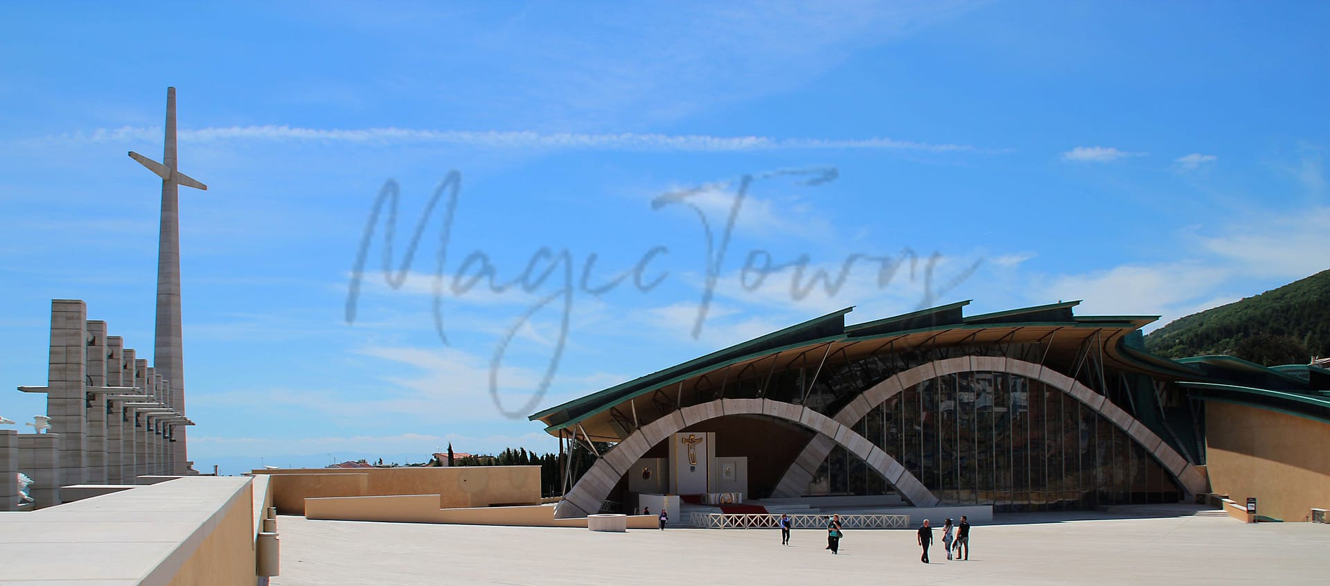
Known for the Sanctuary of Padre Pio, the town’s economy focuses on healthcare and medical tourism.
Quality of Life Score
[?]Factors in air quality, amenities, walkability, population, and environmental risks. Higher scores suggest better living conditions.
74
Quality of Infrastructure
[?]Measures internet speed, healthcare access, airports, rail, and walkability. Higher scores mean better connectivity and essential services.
55
Quality of Economy
[?]Based on income, property prices, job availability, and population density. Higher scores indicate stronger economic conditions.
69
San Giovanni Rotondo Demographics
Population
[?]
This is a town's official population, measured each year by the national statistics authority.
26300
Real Population (5km band)
[?]
Our "Real Population" metric reflects more accurately a town's real size by including inhabitants in the immediate vicinity of the town's official borders.
41400
Births Per 100 Deaths
80.0
Population Data Source
ISTAT,2023
Estimated Unemployment Rate
Touristy Index
[?]
Calculation of tourist density index for the city, comparing its total tourist number to the overall average tourist number of the region
relative to its own population.The index indicates how a location’s tourist density compares to the average, with values above
100 representing higher-than-average density and values below 100 representing lower-than-average density.
Moderate Tourism
Income per capita (2023)
[?]
This is an estimation of average income per resident for this town, based on 2023 data from the Italian Ministry of Finance.
20800
Income rank in Italy (2023)
[?]
This is a ranking of the town's average income per resident, against the full list of townships in Italy.
3623 out of 7901
Infrastructure and Connectivity
Create an account to explore more
This content is for Members only | Already a Member? Sign in
Closest Airport
Name
Karol Wojtyla (Bari)
Connectivity Score
[?]
Measures travel time and service quality of nearby airport stations. Higher scores mean better transport access.
7
Driving Time
76min(s)
Bari Karol Wojtyła Airport is located approximately 8 kilometres northwest of Bari, Italy, and serves as a significant hub in the Puglia region. It handled over 6 million passengers in 2023, largely acting as a focus city for low-cost carriers like Ryanair and Volotea. The airport connects to numerous European cities, with main routes including destinations such as London, Paris, Milan, and Istanbul, and benefits from seasonal services to cities like New York and Vienna, marking it as a convenient base for both domestic and international travel.
2nd Closest Airport
Name
Abruzzo Airport (Pescara)
Connectivity Score
[?]
Measures travel time and service quality of nearby airport stations. Higher scores mean better transport access.
7
Driving Time
96min(s)
Abruzzo Airport, located about 4 kilometers from Pescara city centre and approximately 180 kilometers from Rome, is a medium-sized international gateway serving Abruzzo and neighbouring regions such as Molise and Marche. Handling over 700,000 passengers in 2022, the airport connects travellers to 18 destinations across 11 countries, with key routes including London Stansted, Milan, Bucharest, and Malta. Notably, it offers budget-friendly parking options and serves as a hub for low-cost carriers like Ryanair, facilitating both domestic and international travel.
3rd Closest Airport
Name
Capodichino (Naples)
Connectivity Score
[?]
Measures travel time and service quality of nearby airport stations. Higher scores mean better transport access.
9
Driving Time
120min(s)
Capodichino Airport, officially known as Naples International Airport, is located in Capodichino, Naples, Campania, Italy, approximately 5.9 km north-northeast of Naples city centre. It is the largest airport in Southern Italy, handling over 12 million passengers annually, and serves as a base for airlines such as easyJet, Ryanair, Volotea, and Wizz Air. The airport offers connections to major domestic destinations like Milan and Turin, as well as international routes to cities including Barcelona, London, Munich, Frankfurt, and New York City, making it a key hub for travellers in the Mediterranean region.
Closest Rail
Name
Stazione di Manfredonia
Connectivity Score
[?]
Measures travel time and service quality of nearby rail stations. Higher scores mean better transport access.
7
Driving Time
21min(s)
Train service at Stazione di Manfredonia includes stops on rail lines operated by Trenitalia. Key destinations connected by direct trains include Rome, Bari Centrale, Barletta, and Naples. Train frequencies vary, with some routes offering a few services per day, while others might see trains operating every four hours. The station mainly provides regional train services rather than high-speed options.
2nd Closest Rail
Name
Stazione di Siponto
Connectivity Score
[?]
Measures travel time and service quality of nearby rail stations. Higher scores mean better transport access.
5
Driving Time
22min(s)
Train service at Stazione di Siponto includes the following features:
– **Rail lines that stop here**: The station is primarily served by regional rail lines operated by Trenitalia.
– **Key destinations connected by direct trains**: Direct trains connect Siponto to key destinations including Bari Centrale and Foggia.
– **Train operators**: Services are provided by Trenitalia and Italo.
– **Frequency of departures**: Trains to Bari Centrale operate approximately six times a day, and there are services to Foggia every four hours.
– **High-speed or regional**: The station primarily features regional services rather than high-speed trains.
3rd Closest Rail
Name
Stazione di Rignano Garganico
Connectivity Score
[?]
Measures travel time and service quality of nearby rail stations. Higher scores mean better transport access.
4
Driving Time
31min(s)
Train service at Stazione di Rignano Garganico provides essential regional connections in the Italian railway network. The station is served predominantly by regional trains operated by Trenitalia, catering to passengers wishing to travel to nearby towns and cities.
### Rail Lines:
– The primary rail line servicing the station is the Foggia to Barletta line.
### Key Destinations:
– Passengers can take direct trains to several key destinations, including Foggia and Barletta.
### Train Operators:
– The main train operator at this station is Trenitalia, which is responsible for regional rail services. High-speed services, such as those offered by Italo, do not stop at this station.
### Frequency of Departures:
– Trains typically operate on an hourly basis, with some services running more frequently during peak times, while a few may be offered during off-peak hours.
### Train Types:
– Stazione di Rignano Garganico mainly offers regional train services, without high-speed options available.
Infrastructure & Amenities
Create an account to explore more
This content is for Members only | Already a Member? Sign in
Healthcare
Create an account to explore more
This content is for Members only | Already a Member? Sign in
Housing & Property Market
Create an account to explore more
This content is for Members only | Already a Member? Sign in
Connectivity & Digital Access
Create an account to explore more
This content is for Members only | Already a Member? Sign in
Education
Create an account to explore more
This content is for Members only | Already a Member? Sign in
Climate & Weather
Create an account to explore more
This content is for Members only | Already a Member? Sign in
Precipitation
[?] Based on daily climate data for precipitation from OPEN-METEO this parameter indicates how a city's annual precipitation compares to others in terms of percentage, with values ranging from 0 (lowest) to 1 (highest). For example, a percentile rank of 0.75 means the city's total precipitation is higher than 75% of other cities.
Low (11th-20th percentile)
Sunshine
Very High (81st-90th percentile)
Snowfall
Below Average (31st-40th percentile)
Min Annual Temperature (°C)
[?] This parameter represents the monthly average of daily minimum temperatures for January, based on data from OPEN-METEO.
2.8
Max Annual Temperature (°C)
[?] This parameter represents the monthly average of daily minimum temperatures for January, based on data from OPEN-METEO.
27.9
Climate Description
San Giovanni Rotondo presents a climate that balances warmth and precipitation well throughout the year. The region enjoys abundant sunshine, enriching the picturesque landscapes that change vividly across the seasons. Despite experiencing occasional snowfall, winters here remain relatively mild, making it an amenable environment for expats and retirees from cooler climates. Summers are characterized by warm but rarely oppressive heat, providing wonderful conditions for exploring the historic town and its beautiful surroundings. Overall, the town's moderate temperatures combined with ample sunlight create a favorable setting for those looking to enjoy the serene Italian lifestyle away from harsher weather extremes.
Annual Temperature Chart (Min)
Error
There was a problem with your SQL connection - Please contact the administrator
There was a problem with your SQL connection - Please contact the administrator
Annual Temperature Chart (Max)
Error
There was a problem with your SQL connection - Please contact the administrator
There was a problem with your SQL connection - Please contact the administrator
Sunny Days By Month
Error
There was a problem with your SQL connection - Please contact the administrator
There was a problem with your SQL connection - Please contact the administrator
Environmental & Air Quality
Create an account to explore more
This content is for Members only | Already a Member? Sign in
Classifications
PM10
[?]
PM10 levels indicate Good air quality at 0–20 µg/m³, Fair at 20–40 µg/m³, Moderate at 40–50 µg/m³, Poor at 50–100 µg/m³, Very Poor at 100–150 µg/m³, and Extremely Poor at 150–1200 µg/m³.
Good
PM2.5
[?]
PM2.5 is Good if PM2.5 levels are between 0–10 µg/m³, Fair between 10–20 µg/m³, Moderate between 20–25 µg/m³, Poor between 25–50 µg/m³, Very Poor between 50–75 µg/m³, and Extremely Poor between 75–800 µg/m³.
Good
NO2
[?]
NO₂ levels are considered Good at 0–40 µg/m³, Fair at 40–90 µg/m³, Moderate at 90–120 µg/m³, Poor at 120–230 µg/m³, Very Poor at 230–340 µg/m³, and Extremely Poor at 340–1000 µg/m³.
Good
SO2
[?]
SO₂ levels indicate Good air quality at 0–100 µg/m³, Fair at 100–200 µg/m³, Moderate at 200–350 µg/m³, Poor at 350–500 µg/m³, Very Poor at 500–750 µg/m³, and Extremely Poor at 750–1250 µg/m³.
Good
O₃
[?]
For O₃, the air is Good at 0–50 µg/m³, Fair at 50–100 µg/m³, Moderate at 100–130 µg/m³, Poor at 130–240 µg/m³, Very Poor at 240–380 µg/m³, and Extremely Poor at 380–800 µg/m³.
Fair
Air Quality Rating
[?]
Based on PM10, PM2.5, NO2, SO2, and ozone levels. Higher scores indicate cleaner air.
84
Air Quality Description
San Giovanni Rotondo, nestled in Italy, offers residents an environment where the air quality predominantly aligns with good standards for particulate matter and gases like nitrogen and sulphur dioxides. However, a point of attention is the ozone levels, which are considered fair and might provoke consideration for those particularly sensitive to this component of air quality. With a general commitment to maintaining these levels, the town promises a conducive atmosphere for both daily activities and relaxation, making it an attractive option for expats and retirees seeking a blend of clean air and Italian charm.
San Giovanni Rotondo, nestled in Italy, offers residents an environment where the air quality predominantly aligns with good standards for particulate matter and gases like nitrogen and sulphur dioxides. However, a point of attention is the ozone levels, which are considered fair and might provoke consideration for those particularly sensitive to this component of air quality. With a general commitment to maintaining these levels, the town promises a conducive atmosphere for both daily activities and relaxation, making it an attractive option for expats and retirees seeking a blend of clean air and Italian charm.
Town Descriptions
Create an account to explore more
This content is for Members only | Already a Member? Sign in
Getting There
San Giovanni Rotondo is accessible via the SS272 and SS89 roads, linking it to major towns in the region. The nearest airport is Karol Wojtyla in Bari, while the Abruzzo Airport in Pescara serves as a secondary option. Public transport options include two nearby train stations, reflecting moderate connectivity.
Getting Around
Local Cuisine
San Giovanni Rotondo, located in the Puglia region, showcases a culinary scene characterized by its rich traditional offerings and local ingredients. The area is renowned for dishes such as ‘orecchiette,’ a type of pasta commonly served with broccoli rabe, as well as ‘taralli,’ ‘focaccia,’ and various cheese specialties like ‘caciocavallo,’ ‘mozzarella,’ and ‘burrata.’ The dining establishments reflect a blend of local Puglian flavors with some international influences, particularly in modern cuisine transformations. Notably, the town is home to a Michelin-starred restaurant, enhancing its gastronomic prestige. Overall, dining in San Giovanni Rotondo offers a vibrant tapestry of flavors ranging from traditional to contemporary, serving both local patrons and international visitors.
Shopping Overview
The shopping landscape includes a blend of supermarkets, diverse boutiques, and dedicated shopping centres. Noteworthy are shopping malls, which provide a broad range of retail options. Specialty shops cater to unique gift items and local products, enhancing the shopping experience. Open-air markets feature fresh produce and artisan goods, appealing to those seeking authentic local flavours. Overall, the area combines modern retail environments with traditional market charm, suitable for both casual shoppers and those looking for specific items.
Neighborhoods
Green Areas and Parks
San Giovanni Rotondo in Puglia offers notable outdoor activities, including hikes and natural exploration. Monte Calvo is a prominent mountain offering scenic views and challenging routes for hikers. Valle dell’Inferno and Monte Nero are popular hiking trails, providing diverse terrains for walking enthusiasts. Additionally, Parco Del Papa offers a tranquil park setting suitable for leisurely strolls and nature appreciation. These attractions underscore the area’s appeal for those interested in outdoor activities amidst the natural landscapes of Puglia.
✅ Pros
– High-quality healthcare facilities available in the region.
– Moderate tourism fosters a vibrant local economy.
– Beautiful climate with warm summers and mild winters.
– Rich cultural and historical heritage to explore.
– Friendly community encourages integration and social connections.
– Relatively low unemployment rate compared to national average.
– Sufficient transportation options for local and regional travel.
– Good air quality for healthy living conditions.
– Affordable cost of living compared to larger cities.
– Opportunities for outdoor activities in scenic surroundings.
❌ Cons
– Limited educational facilities for higher-level studies nearby.
– Internet speeds may frustrate your binge-watching plans.
– Infrastructure improvements needed for better accessibility and convenience.
– Off-season tourism can make town feel a bit deserted.
– Fewer entertainment options compared to larger cities.
– Language barrier can complicate daily interactions.
– Local cuisine may not suit everyone’s taste buds.
– Public transportation schedules can be inconsistent at times.
– Limited shopping choices for diverse consumer needs.
– Cultural events may not be frequent throughout the year.
FAQs
Summary
San Giovanni Rotondo, located in the heart of Puglia, presents an interesting blend of historical significance and modernity. The town is renowned for the Sanctuary of Padre Pio, a monumental church dedicated to its healing patron saint, drawing visitors from around the globe. This notable site significantly influences the local economy, which largely revolves around healthcare, given the presence of one of the largest hospitals in the region that attracts a diverse international medical community.
While the town boasts a commendable walk score, making it easy to navigate on foot, expats may find certain lifestyle aspects challenging. The local culture leans towards quietness rather than vibrant nightlife, which could be a consideration for those seeking more social engagement. Additionally, while healthcare services are relatively good, other amenities may not meet the expectations of some retirees. The nearest beach, although beautiful, is a short drive away, and air connectivity offers convenience albeit limited options.
✅ Pros
– High-quality healthcare facilities available in the region.
– Moderate tourism fosters a vibrant local economy.
– Beautiful climate with warm summers and mild winters.
– Rich cultural and historical heritage to explore.
– Friendly community encourages integration and social connections.
– Relatively low unemployment rate compared to national average.
– Sufficient transportation options for local and regional travel.
– Good air quality for healthy living conditions.
– Affordable cost of living compared to larger cities.
– Opportunities for outdoor activities in scenic surroundings.
❌ Cons
– Limited educational facilities for higher-level studies nearby.
– Internet speeds may frustrate your binge-watching plans.
– Infrastructure improvements needed for better accessibility and convenience.
– Off-season tourism can make town feel a bit deserted.
– Fewer entertainment options compared to larger cities.
– Language barrier can complicate daily interactions.
– Local cuisine may not suit everyone’s taste buds.
– Public transportation schedules can be inconsistent at times.
– Limited shopping choices for diverse consumer needs.
– Cultural events may not be frequent throughout the year.
Related Posts
No posts found for the town.
More questions about San Giovanni Rotondo ? Ask Magic AI.
Our innovative AI assistant is eager to help. Try it out here: