
Elevation
[?]
Elevation of a city refers to the height above sea level at which the city is located, measured in meters.
95
Population
[?]
This is a town's official population, measured each year by the national statistics authority.
10400
Real Population (5km)
[?]
Our "Real Population" metric reflects more accurately a town's real size by including inhabitants in the immediate vicinity of the town's official borders.
66700
Air Quality Rating
[?]
Based on PM10, PM2.5, NO2, SO2, and ozone levels. Higher scores indicate cleaner air.
76
Region
Lombardia
Walkability
Very Walkable
Housing availability
[?]
Based on total number of properties (sale and rent) classifies housing availability into five categories: low, relativel ylow, medium, relatively high and high.
Relatively Low
Avg Download Speed (Mbps) / Avg Upload Speed (Mbps)
76
/ 24
Climate Description
Temperate climate with mild winters, warm summers, ample sunshine, and minimal temperature variation.
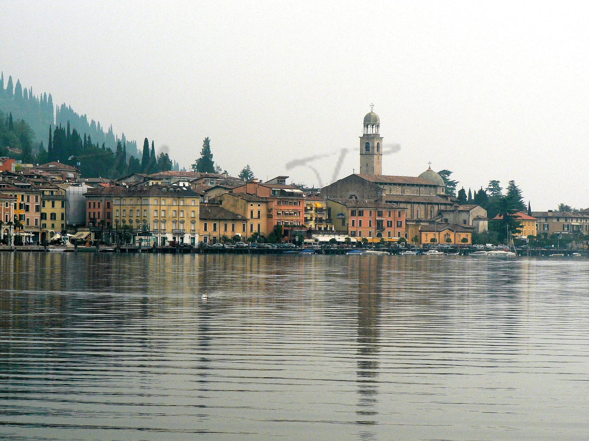
Salò
Lombardia
Historic town on Lake Garda with a charming center, notable architecture, and cultural events.
Quality of Life Score
[?]Factors in air quality, amenities, walkability, population, and environmental risks. Higher scores suggest better living conditions.
83
Quality of Infrastructure
[?]Measures internet speed, healthcare access, airports, rail, and walkability. Higher scores mean better connectivity and essential services.
55
Quality of Economy
[?]Based on income, property prices, job availability, and population density. Higher scores indicate stronger economic conditions.
79
Salò Demographics
Population
[?]
This is a town's official population, measured each year by the national statistics authority.
10400
Real Population (5km band)
[?]
Our "Real Population" metric reflects more accurately a town's real size by including inhabitants in the immediate vicinity of the town's official borders.
66700
Births Per 100 Deaths
40.0
Population Data Source
ISTAT,2023
Estimated Unemployment Rate
Touristy Index
[?]
Calculation of tourist density index for the city, comparing its total tourist number to the overall average tourist number of the region
relative to its own population.The index indicates how a location’s tourist density compares to the average, with values above
100 representing higher-than-average density and values below 100 representing lower-than-average density.
Tourism Hotspot (5.8 tourists per resident)
Income per capita (2023)
[?]
This is an estimation of average income per resident for this town, based on 2023 data from the Italian Ministry of Finance.
24800
Income rank in Italy (2023)
[?]
This is a ranking of the town's average income per resident, against the full list of townships in Italy.
507 out of 7901
Infrastructure and Connectivity
Create an account to explore more
This content is for Members only | Already a Member? Sign in
Closest Airport
Name
Montichiari (Brescia)
Connectivity Score
[?]
Measures travel time and service quality of nearby airport stations. Higher scores mean better transport access.
3
Driving Time
31min(s)
Montichiari Airport, officially known as Brescia “Gabriele D’Annunzio” Airport (IATA: VBS), is located in Montichiari, southeast of Brescia in Lombardy, Italy. Currently, it does not support scheduled passenger services and primarily operates as a cargo airport, notably for Poste Italiane, with Rome-Fiumicino being a key destination. The airport serves as a cargo hub for airlines like Poste Air Cargo, DHL, and Silk Way West Airlines.
2nd Closest Airport
Name
Orio al Serio (Bergamo)
Connectivity Score
[?]
Measures travel time and service quality of nearby airport stations. Higher scores mean better transport access.
7
Driving Time
51min(s)
Orio al Serio International Airport, also known as Milan Bergamo Airport, is located just 5 km from Bergamo and about 45 km from Milan in Lombardy, Italy. It is the third busiest airport in Italy, serving over 13 million passengers annually and acting as a major hub for Ryanair. The airport connects to numerous European destinations including Copenhagen, Düsseldorf, as well as farther routes like Dubai and Cairo. Known for its budget-friendly flights primarily operated by Ryanair, Milan Bergamo Airport is a popular choice for travellers looking for affordable options to various international destinations.
3rd Closest Airport
Name
Valerio Catullo (Verona)
Connectivity Score
[?]
Measures travel time and service quality of nearby airport stations. Higher scores mean better transport access.
7
Driving Time
51min(s)
Valerio Catullo Airport, also known as Verona Villafranca Airport, is situated 10 km southwest of Verona in Italy’s Veneto region. It is a significant regional hub, particularly for Air Dolomiti, Neos, and Volotea, handling nearly 3 million passengers in 2022. The airport offers connections to 80 destinations, ranging from European cities like Paris and Barcelona to long-haul routes in Africa and the Caribbean. Known for its accessibility via major motorways A4 and A22, it provides convenient options for travellers with features like a VIP lounge and fast track services.
Closest Rail
Name
Stazione di Lonato
Connectivity Score
[?]
Measures travel time and service quality of nearby rail stations. Higher scores mean better transport access.
5
Driving Time
27min(s)
Train service at Stazione di Lonato includes a selection of regional train services only, primarily operated by Trenitalia and Trenord. The station lies on the Milan–Venice railway line.
– **Rail Lines:** The key rail line that stops here is the Milan–Venice railway.
– **Key Destinations:** Direct trains connect Lonato with major destinations such as Brescia, Desenzano del Garda, Peschiera del Garda, and Verona. There are also infrequent services extending to Vicenza, Padua, and Venice (operating once per day).
– **Train Operators:** The primary operators at this station are Trenitalia and Trenord, focusing on regional services.
– **Frequency of Departures:** Departures tend to be hourly, with some trains operating less frequently, particularly those to further destinations.
– **High-Speed Services:** The station primarily offers regional services with no high-speed train options available.
2nd Closest Rail
Name
Stazione di Desenzano del Garda-Sirmione
Connectivity Score
[?]
Measures travel time and service quality of nearby rail stations. Higher scores mean better transport access.
8
Driving Time
28min(s)
Train service at Stazione di Desenzano del Garda-Sirmione includes several key features:
– **Rail Lines**: The station is situated on the Milan–Venice railway, accommodating various train services.
– **Key Destinations**: Direct trains connect Desenzano del Garda-Sirmione to major destinations including Milan, Venice, Verona, and Genoa, among others.
– **Train Operators**: The primary operators are Trenitalia and Italo, offering a range of services.
– **Frequency of Departures**: Trains typically depart with a frequency of approximately every 30 minutes to an hour, but this can vary based on the time of day and service type.
– **Train Types**: The station handles a mix of high-speed trains (such as Frecciarossa) and regional services, providing options for both long-distance and local travel.
3rd Closest Rail
Name
Stazione di Montirone
Connectivity Score
[?]
Measures travel time and service quality of nearby rail stations. Higher scores mean better transport access.
5
Driving Time
37min(s)
Train service at Stazione di Montirone includes the following key details:
– **Rail lines that stop here**: The station is served primarily by regional rail lines operated by Trenord, connecting Montirone with nearby cities.
– **Key destinations connected by direct trains**: Direct trains from Montirone typically connect to Brescia, a significant nearby city. Other regional destinations may include towns and cities within the Lombardy region.
– **Train operators**: Trenord is the main operator of train services at Stazione di Montirone, primarily focused on regional trains.
– **Frequency of departures**: Trains generally operate on an hourly basis from Montirone, with services depending on the specific day and time.
– **Type of trains**: The station primarily features regional trains, with no high-speed services stopping at this station.
Infrastructure & Amenities
Create an account to explore more
This content is for Members only | Already a Member? Sign in
Healthcare
Create an account to explore more
This content is for Members only | Already a Member? Sign in
Housing & Property Market
Create an account to explore more
This content is for Members only | Already a Member? Sign in
Connectivity & Digital Access
Create an account to explore more
This content is for Members only | Already a Member? Sign in
Education
Create an account to explore more
This content is for Members only | Already a Member? Sign in
Climate & Weather
Create an account to explore more
This content is for Members only | Already a Member? Sign in
Precipitation
[?] Based on daily climate data for precipitation from OPEN-METEO this parameter indicates how a city's annual precipitation compares to others in terms of percentage, with values ranging from 0 (lowest) to 1 (highest). For example, a percentile rank of 0.75 means the city's total precipitation is higher than 75% of other cities.
Average (41st-50th percentile)
Sunshine
Below Average (31st-40th percentile)
Snowfall
Below Average (31st-40th percentile)
Min Annual Temperature (°C)
[?] This parameter represents the monthly average of daily minimum temperatures for January, based on data from OPEN-METEO.
1
Max Annual Temperature (°C)
[?] This parameter represents the monthly average of daily minimum temperatures for January, based on data from OPEN-METEO.
28.1
Climate Description
Benefitting from a temperate climate, Salò offers a comfortable environment characterized by mild winters and warm summers, suitable for both expats and retirees seeking a steady weather pattern. The town experiences ample sunshine throughout the year, ensuring that outdoor activities and lakeside relaxation are seldom interrupted by harsh weather conditions. There is a light dusting of snow occasionally, a picturesque addition rather than an inconvenience. The minimal seasonal variation in temperature allows for year-round enjoyment of Salò's charm, from its historic architecture to the natural beauty of its surroundings, making it an attractive destination in Italy for those inclined towards magical and serene settings.
Annual Temperature Chart (Min)
Error
There was a problem with your SQL connection - Please contact the administrator
There was a problem with your SQL connection - Please contact the administrator
Annual Temperature Chart (Max)
Error
There was a problem with your SQL connection - Please contact the administrator
There was a problem with your SQL connection - Please contact the administrator
Sunny Days By Month
Error
There was a problem with your SQL connection - Please contact the administrator
There was a problem with your SQL connection - Please contact the administrator
Environmental & Air Quality
Create an account to explore more
This content is for Members only | Already a Member? Sign in
Classifications
PM10
[?]
PM10 levels indicate Good air quality at 0–20 µg/m³, Fair at 20–40 µg/m³, Moderate at 40–50 µg/m³, Poor at 50–100 µg/m³, Very Poor at 100–150 µg/m³, and Extremely Poor at 150–1200 µg/m³.
Good
PM2.5
[?]
PM2.5 is Good if PM2.5 levels are between 0–10 µg/m³, Fair between 10–20 µg/m³, Moderate between 20–25 µg/m³, Poor between 25–50 µg/m³, Very Poor between 50–75 µg/m³, and Extremely Poor between 75–800 µg/m³.
Fair
NO2
[?]
NO₂ levels are considered Good at 0–40 µg/m³, Fair at 40–90 µg/m³, Moderate at 90–120 µg/m³, Poor at 120–230 µg/m³, Very Poor at 230–340 µg/m³, and Extremely Poor at 340–1000 µg/m³.
Good
SO2
[?]
SO₂ levels indicate Good air quality at 0–100 µg/m³, Fair at 100–200 µg/m³, Moderate at 200–350 µg/m³, Poor at 350–500 µg/m³, Very Poor at 500–750 µg/m³, and Extremely Poor at 750–1250 µg/m³.
Good
O₃
[?]
For O₃, the air is Good at 0–50 µg/m³, Fair at 50–100 µg/m³, Moderate at 100–130 µg/m³, Poor at 130–240 µg/m³, Very Poor at 240–380 µg/m³, and Extremely Poor at 380–800 µg/m³.
Fair
Air Quality Rating
[?]
Based on PM10, PM2.5, NO2, SO2, and ozone levels. Higher scores indicate cleaner air.
76
Air Quality Description
In Salò, Italy, the air quality generally holds at ‘Good’ to ‘Fair’ levels, positioning it favorably for those seeking a new domicile with a healthier environmental setting. Particulate matter sizes PM10 and PM2.5, critical to gauging air cleanliness, are maintained well within satisfactory limits, reflecting a commendable PM10 status and moderate PM2.5 conditions. Salò also shows notably low concentrations of nitrogen and sulphur dioxides, both indicative of lesser industrial pollution and favorable respiratory health conditions. However, ozone levels, while acceptable, suggest periodic attentiveness to local air quality reports would be beneficial for those with sensitivity to such parameters.
In Salò, Italy, the air quality generally holds at ‘Good’ to ‘Fair’ levels, positioning it favorably for those seeking a new domicile with a healthier environmental setting. Particulate matter sizes PM10 and PM2.5, critical to gauging air cleanliness, are maintained well within satisfactory limits, reflecting a commendable PM10 status and moderate PM2.5 conditions. Salò also shows notably low concentrations of nitrogen and sulphur dioxides, both indicative of lesser industrial pollution and favorable respiratory health conditions. However, ozone levels, while acceptable, suggest periodic attentiveness to local air quality reports would be beneficial for those with sensitivity to such parameters.
Town Descriptions
Create an account to explore more
This content is for Members only | Already a Member? Sign in
Getting There
Salò is accessible via the A4 motorway, connecting it to major cities in Northern Italy. The nearest airports are Montichiari and Bergamo, while local train stations offer limited connectivity. The town’s infrastructure is rated moderate, reflecting its functional but not extensive transport options.
Getting Around
Local Cuisine
Salò’s culinary scene is marked by a rich blend of traditional Lombard cuisine and innovative dining experiences. Local specialties include ‘risotto con persico’ (risotto with perch) and lake fish, showcasing the region’s bountiful waters. The town offers a diverse array of dining venues, ranging from cozy trattorias to fine dining establishments. Notably, Salò is home to Michelin-starred restaurants, such as Il Fagiano and Lido 84, which highlight contemporary Italian cuisine with an emphasis on local ingredients. The presence of international influences is evident, providing a well-rounded gastronomic landscape that caters to various palates and preferences.
Shopping Overview
The shopping landscape offers a diverse array of options catered to various tastes and preferences. A charming shopping street features chic boutiques and design shops, providing a leisurely shopping experience. Exclusive boutiques present high-end fashion, along with shops dedicated to regional specialties and souvenirs. Additionally, vintage shops offer antiques and unique finds, contributing to a distinct shopping culture. Supermarkets and local markets supply everyday goods, ensuring residents have access to essential items. Overall, the shopping scene combines convenience with a touch of luxury, appealing to both expats and retirees.
Neighborhoods
Green Areas and Parks
In the picturesque town on Lake Garda’s western shore, outdoor activities abound with scenic trails and parklands. The Alto Garda Bresciano Regional Park offers routes like the challenging 3.8-mile San Bartolomeo Church trail and the moderate 5.8-mile Monte San Bartolomeo circuit, both delivering views of the Madonna del Rio waterfall. Additionally, the 10.2-mile Bassa Via del Garda leads hikers through diverse landscapes of olive groves and canyons. For diverse exploration, the Three Lakes Tour spans 45.8 miles across Idro, Valvestino, and Garda Lakes. The area combines natural beauty with accessible activity options for enthusiasts.
✅ Pros
– High-quality healthcare services for residents and expats.
– Mild climate with warm summers and mild winters.
– Rich cultural and historical heritage to explore and appreciate.
– Excellent integration opportunities within the local community.
– Vibrant tourism enhances local economy and cultural events.
– Low unemployment rate supports economic stability and growth.
– Adequate transportation options for easy regional accessibility.
– Scenic views of Lake Garda and surrounding mountains.
– Engaging social activities and events throughout the year.
– Sufficient internet connectivity for remote work and communication.
❌ Cons
– Limited infrastructure development may affect daily conveniences.
– Air quality could be better for sensitive individuals.
– High tourist traffic might disrupt local tranquility and peace.
– Seasonal influx may lead to crowded public spaces.
– Healthcare, while good, may have wait times for specialists.
– Internet speed, though sufficient, may not satisfy heavy users.
– Limited educational facilities for families with children.
– Cost of living can be higher due to tourism demand.
– Public transportation may lack extensive routes and schedules.
– Local dialects can hinder integration for non-Italian speakers.
FAQs
Summary
Salò, nestled on the Brescian shore of Lake Garda, offers a blend of historical charm and modern amenities, making it appealing for expatriates and retirees alike. This elegant town, once the capital of the Magnifica Patria during Venetian rule, features a picturesque historic center with narrow streets, stately homes, and squares that reflect its noble past. Key attractions include the striking Cathedral, Palazzo della Magnifica Patria, and the charming lakeside promenade, where leisure seekers can enjoy dining options and local markets.
Although Salò has considerable appeal, it encounters challenges typical of Italian towns, such as limited public transportation options and a slower pace of life that may require adjustment for those used to a fast-paced lifestyle. Yet, its proximity to the pristine shores of Lake Garda and vibrant cultural events, including classical music concerts, provide ample opportunities for engagement and enjoyment in this serene setting.
✅ Pros
– High-quality healthcare services for residents and expats.
– Mild climate with warm summers and mild winters.
– Rich cultural and historical heritage to explore and appreciate.
– Excellent integration opportunities within the local community.
– Vibrant tourism enhances local economy and cultural events.
– Low unemployment rate supports economic stability and growth.
– Adequate transportation options for easy regional accessibility.
– Scenic views of Lake Garda and surrounding mountains.
– Engaging social activities and events throughout the year.
– Sufficient internet connectivity for remote work and communication.
❌ Cons
– Limited infrastructure development may affect daily conveniences.
– Air quality could be better for sensitive individuals.
– High tourist traffic might disrupt local tranquility and peace.
– Seasonal influx may lead to crowded public spaces.
– Healthcare, while good, may have wait times for specialists.
– Internet speed, though sufficient, may not satisfy heavy users.
– Limited educational facilities for families with children.
– Cost of living can be higher due to tourism demand.
– Public transportation may lack extensive routes and schedules.
– Local dialects can hinder integration for non-Italian speakers.
Related Posts
No posts found for the town.
More questions about Salò ? Ask Magic AI.
Our innovative AI assistant is eager to help. Try it out here: