Elevation
[?]
Elevation of a city refers to the height above sea level at which the city is located, measured in meters.
122
Population
[?]
This is a town's official population, measured each year by the national statistics authority.
20700
Real Population (5km)
[?]
Our "Real Population" metric reflects more accurately a town's real size by including inhabitants in the immediate vicinity of the town's official borders.
78500
Air Quality Rating
[?]
Based on PM10, PM2.5, NO2, SO2, and ozone levels. Higher scores indicate cleaner air.
76
Region
Lombardia
Walkability
Walker’s Paradise
Housing availability
[?]
Based on total number of properties (sale and rent) classifies housing availability into five categories: low, relativel ylow, medium, relatively high and high.
Low
Avg Download Speed (Mbps) / Avg Upload Speed (Mbps)
110
/ 49
Climate Description
Balanced temps year-round, mild winters, warm summers, abundant sun, and well-distributed rain.
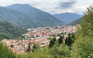
Romano di Lombardia
Lombardia
Historic town with medieval layout, notable landmarks, cultural scene, and tranquil lifestyle near Bergamo.
Quality of Life Score
[?]Factors in air quality, amenities, walkability, population, and environmental risks. Higher scores suggest better living conditions.
83
Quality of Infrastructure
[?]Measures internet speed, healthcare access, airports, rail, and walkability. Higher scores mean better connectivity and essential services.
76
Quality of Economy
[?]Based on income, property prices, job availability, and population density. Higher scores indicate stronger economic conditions.
72
Romano di Lombardia Demographics
Population
[?]
This is a town's official population, measured each year by the national statistics authority.
20700
Real Population (5km band)
[?]
Our "Real Population" metric reflects more accurately a town's real size by including inhabitants in the immediate vicinity of the town's official borders.
78500
Births Per 100 Deaths
80.0
Population Data Source
ISTAT,2023
Estimated Unemployment Rate
Touristy Index
[?]
Calculation of tourist density index for the city, comparing its total tourist number to the overall average tourist number of the region
relative to its own population.The index indicates how a location’s tourist density compares to the average, with values above
100 representing higher-than-average density and values below 100 representing lower-than-average density.
Not Touristic
Income per capita (2023)
[?]
This is an estimation of average income per resident for this town, based on 2023 data from the Italian Ministry of Finance.
22700
Income rank in Italy (2023)
[?]
This is a ranking of the town's average income per resident, against the full list of townships in Italy.
2027 out of 7901
Infrastructure and Connectivity
Create an account to explore more
This content is for Members only | Already a Member? Sign in
Infrastructure & Amenities
Create an account to explore more
This content is for Members only | Already a Member? Sign in
Healthcare
Create an account to explore more
This content is for Members only | Already a Member? Sign in
Housing & Property Market
Create an account to explore more
This content is for Members only | Already a Member? Sign in
Connectivity & Digital Access
Create an account to explore more
This content is for Members only | Already a Member? Sign in
Education
Create an account to explore more
This content is for Members only | Already a Member? Sign in
Climate & Weather
Create an account to explore more
This content is for Members only | Already a Member? Sign in
Precipitation
[?] Based on daily climate data for precipitation from OPEN-METEO this parameter indicates how a city's annual precipitation compares to others in terms of percentage, with values ranging from 0 (lowest) to 1 (highest). For example, a percentile rank of 0.75 means the city's total precipitation is higher than 75% of other cities.
Somewhat High (61st-70th percentile)
Sunshine
Below Average (31st-40th percentile)
Snowfall
Average (41st-50th percentile)
Min Annual Temperature (°C)
[?] This parameter represents the monthly average of daily minimum temperatures for January, based on data from OPEN-METEO.
-1.1
Max Annual Temperature (°C)
[?] This parameter represents the monthly average of daily minimum temperatures for January, based on data from OPEN-METEO.
28.4
Climate Description
Romano di Lombardia experiences a climate marked by relatively balanced temperatures year-round, with mild winters occasionally dipping just below freezing and warm, pleasant summers peaking in the upper 20s. The area enjoys an abundance of sunshine throughout the year, contributing to its appeal among expats and retirees seeking to escape gloomier climates. Precipitation is well-distributed across the seasons, ensuring the lushness of the local flora without overwhelming residents with excessive rainfall. Light snowfall may occur during winter, adding a brief, picturesque change to the landscape without causing significant disruptions. This climate supports an outdoor lifestyle and offers a comfortable setting for both leisure and everyday living.
Annual Temperature Chart (Min)
Error
There was a problem with your SQL connection - Please contact the administrator
There was a problem with your SQL connection - Please contact the administrator
Annual Temperature Chart (Max)
Error
There was a problem with your SQL connection - Please contact the administrator
There was a problem with your SQL connection - Please contact the administrator
Sunny Days By Month
Error
There was a problem with your SQL connection - Please contact the administrator
There was a problem with your SQL connection - Please contact the administrator
Environmental & Air Quality
Create an account to explore more
This content is for Members only | Already a Member? Sign in
Classifications
PM10
[?]
PM10 levels indicate Good air quality at 0–20 µg/m³, Fair at 20–40 µg/m³, Moderate at 40–50 µg/m³, Poor at 50–100 µg/m³, Very Poor at 100–150 µg/m³, and Extremely Poor at 150–1200 µg/m³.
Fair
PM2.5
[?]
PM2.5 is Good if PM2.5 levels are between 0–10 µg/m³, Fair between 10–20 µg/m³, Moderate between 20–25 µg/m³, Poor between 25–50 µg/m³, Very Poor between 50–75 µg/m³, and Extremely Poor between 75–800 µg/m³.
Moderate
NO2
[?]
NO₂ levels are considered Good at 0–40 µg/m³, Fair at 40–90 µg/m³, Moderate at 90–120 µg/m³, Poor at 120–230 µg/m³, Very Poor at 230–340 µg/m³, and Extremely Poor at 340–1000 µg/m³.
Good
SO2
[?]
SO₂ levels indicate Good air quality at 0–100 µg/m³, Fair at 100–200 µg/m³, Moderate at 200–350 µg/m³, Poor at 350–500 µg/m³, Very Poor at 500–750 µg/m³, and Extremely Poor at 750–1250 µg/m³.
Good
O₃
[?]
For O₃, the air is Good at 0–50 µg/m³, Fair at 50–100 µg/m³, Moderate at 100–130 µg/m³, Poor at 130–240 µg/m³, Very Poor at 240–380 µg/m³, and Extremely Poor at 380–800 µg/m³.
Fair
Air Quality Rating
[?]
Based on PM10, PM2.5, NO2, SO2, and ozone levels. Higher scores indicate cleaner air.
76
Air Quality Description
In Romano di Lombardia, the air quality tends to reflect a balance typical of many Italian towns, leaning slightly more towards a clean and breathable environment, particularly notable in its nitrogen dioxide and sulphur dioxide levels, both generally regarded as well-contained. Particulate matter levels, including PM10 and PM2.5, are moderately present but are typically within a range considered acceptable for daily activities without significant concern. The town’s ozone levels are reasonable, occasionally reaching higher readings but usually maintaining a fair status. Overall, the atmospheric conditions here acceptably support outdoor lifestyles, which is a positive aspect for anyone considering residency in this charming locale.
In Romano di Lombardia, the air quality tends to reflect a balance typical of many Italian towns, leaning slightly more towards a clean and breathable environment, particularly notable in its nitrogen dioxide and sulphur dioxide levels, both generally regarded as well-contained. Particulate matter levels, including PM10 and PM2.5, are moderately present but are typically within a range considered acceptable for daily activities without significant concern. The town’s ozone levels are reasonable, occasionally reaching higher readings but usually maintaining a fair status. Overall, the atmospheric conditions here acceptably support outdoor lifestyles, which is a positive aspect for anyone considering residency in this charming locale.
Town Descriptions
Create an account to explore more
This content is for Members only | Already a Member? Sign in
Getting There
Romano di Lombardia is well-connected via the A35 motorway, linking to major urban centers. The town’s transportation options are bolstered by nearby train stations, providing efficient rail access. Orio al Serio Airport and Linate Airport facilitate regional and international travel, enhancing accessibility for residents and visitors alike.
Getting Around
Local Cuisine
The culinary scene in Romano di Lombardia is characterized by its deep roots in traditional Lombard cuisine, featuring staple dishes such as risotto, polenta, and ossobuco. Risotto, made from local rice paddies, is a highlight, alongside polenta and tortelli di zucca, a delightful pumpkin-stuffed pasta. The region also boasts Gorgonzola cheese, renowned worldwide. Dining options range from local trattorias serving classic dishes to restaurants influenced by various international cuisines. Notably, although there are several quality establishments, there are no Michelin-starred restaurants in Romano di Lombardia, aligning it more with casual, family-friendly dining experiences rather than high-end gastronomic showcases.
Shopping Overview
The shopping landscape offers a range of options, including supermarkets, specialty shops, and regular weekly markets. Supermarkets provide essential groceries, while various specialty shops cater to specific needs such as gifts and local produce. Weekly markets feature fresh produce and local goods, reflecting regional culinary traditions. Additionally, larger shopping centres and malls in the area host a variety of retail brands and services, enhancing the shopping experience for residents and visitors.
Neighborhoods
Green Areas and Parks
Romano di Lombardia offers a spectrum of outdoor activities and green spaces, suitable for expatriates and retirees. Notable trails include the “Golden Valley Trail,” featuring gentle slopes suitable for various skill levels. The “Giro Ciclabile Fiume Serio,” a popular 20.5-mile cycling trail near the Serio River, presents moderate challenges. Nearby parks, like North Adda Regional Park, provide well-marked routes for walking or jogging, ensuring scenic views over the Adda River. Cave Nature Park, slightly further afield, offers trails with variable difficulty and rich biodiversity, contributing to a diverse outdoor experience.
✅ Pros
– High-quality healthcare services available for residents.
– Efficient transportation network connecting to major cities.
– Favorable unemployment rate supports job opportunities.
– Mild climate with distinct seasons year-round.
– Rich cultural and historical heritage throughout the town.
– Opportunities for community integration and social activities.
– Moderate air quality conducive to a healthy lifestyle.
– Well-rated infrastructure supporting daily living needs.
– Peaceful environment away from tourist crowds.
– Affordable cost of living compared to larger cities.
❌ Cons
– Limited nightlife options for those seeking vibrant entertainment scenes.
– Air quality slightly below optimal for sensitive individuals.
– Internet speeds may not meet demands for heavy users.
– Lack of major tourist attractions can feel isolating.
– Cultural activities may not cater to all interests.
– Smaller educational facilities may limit advanced program options.
– Limited diversity in dining and shopping experiences.
– Weather can be quite humid during summer months.
– Public services may not operate at large-city efficiency.
– Local dialect might pose language barriers for newcomers.
FAQs
Summary
Romano di Lombardia, nestled in the central Bergamo plain, is marked by its historical significance and charming architecture. The town showcases a medieval urban layout alongside notable landmarks such as the Visconti Castle, noble palaces, and serene churches. Its history is intertwined with the legacy of distinguished local figures like Giovan Battista Rubini, whose contributions notably enhanced education and healthcare. The town’s vibrant cultural scene is complemented by the picturesque Serio River Park, ideal for outdoor enthusiasts. While gaining the status of a city in the past century, Romano di Lombardia may offer a quieter lifestyle that might not appeal to everyone. Residents and retirees will find it a pleasant, albeit less dynamic, alternative compared to larger cities, with easy access to nearby Bergamo and quality healthcare services. With a strong community feel and rich heritage, it’s a unique option for those seeking a blend of history and tranquility in Italy.
✅ Pros
– High-quality healthcare services available for residents.
– Efficient transportation network connecting to major cities.
– Favorable unemployment rate supports job opportunities.
– Mild climate with distinct seasons year-round.
– Rich cultural and historical heritage throughout the town.
– Opportunities for community integration and social activities.
– Moderate air quality conducive to a healthy lifestyle.
– Well-rated infrastructure supporting daily living needs.
– Peaceful environment away from tourist crowds.
– Affordable cost of living compared to larger cities.
❌ Cons
– Limited nightlife options for those seeking vibrant entertainment scenes.
– Air quality slightly below optimal for sensitive individuals.
– Internet speeds may not meet demands for heavy users.
– Lack of major tourist attractions can feel isolating.
– Cultural activities may not cater to all interests.
– Smaller educational facilities may limit advanced program options.
– Limited diversity in dining and shopping experiences.
– Weather can be quite humid during summer months.
– Public services may not operate at large-city efficiency.
– Local dialect might pose language barriers for newcomers.
Related Posts
No posts found for the town.
More questions about Romano di Lombardia ? Ask Magic AI.
Our innovative AI assistant is eager to help. Try it out here: