
Elevation
[?]
Elevation of a city refers to the height above sea level at which the city is located, measured in meters.
554
Population
[?]
This is a town's official population, measured each year by the national statistics authority.
73700
Real Population (5km)
[?]
Our "Real Population" metric reflects more accurately a town's real size by including inhabitants in the immediate vicinity of the town's official borders.
206000
Air Quality Rating
[?]
Based on PM10, PM2.5, NO2, SO2, and ozone levels. Higher scores indicate cleaner air.
80
Region
Sicilia
Walkability
Walker’s Paradise
Housing availability
[?]
Based on total number of properties (sale and rent) classifies housing availability into five categories: low, relativel ylow, medium, relatively high and high.
High
Avg Download Speed (Mbps) / Avg Upload Speed (Mbps)
280
/ 158
Climate Description
Mild winters, warm summers, ample sunshine, moderate rain; seamless seasonal transitions.
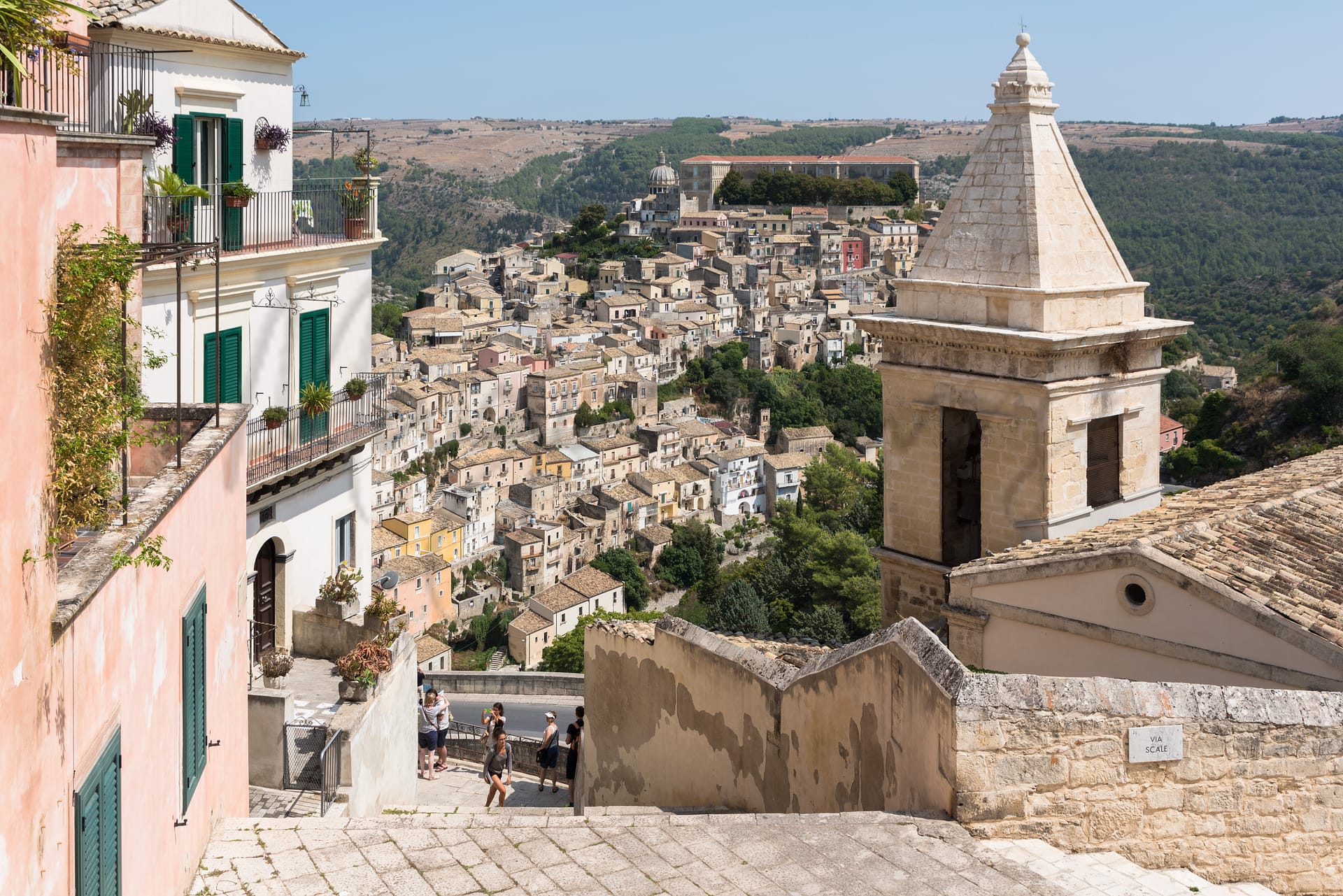
Ragusa
Sicilia
This UNESCO World Heritage site features baroque architecture, rich history, and excellent healthcare.
Quality of Life Score
[?]Factors in air quality, amenities, walkability, population, and environmental risks. Higher scores suggest better living conditions.
91
Quality of Infrastructure
[?]Measures internet speed, healthcare access, airports, rail, and walkability. Higher scores mean better connectivity and essential services.
67
Quality of Economy
[?]Based on income, property prices, job availability, and population density. Higher scores indicate stronger economic conditions.
75
Ragusa Demographics
Population
[?]
This is a town's official population, measured each year by the national statistics authority.
73700
Real Population (5km band)
[?]
Our "Real Population" metric reflects more accurately a town's real size by including inhabitants in the immediate vicinity of the town's official borders.
206000
Births Per 100 Deaths
70.0
Population Data Source
ISTAT,2023
Estimated Unemployment Rate
Touristy Index
[?]
Calculation of tourist density index for the city, comparing its total tourist number to the overall average tourist number of the region
relative to its own population.The index indicates how a location’s tourist density compares to the average, with values above
100 representing higher-than-average density and values below 100 representing lower-than-average density.
Some Tourism
Income per capita (2023)
[?]
This is an estimation of average income per resident for this town, based on 2023 data from the Italian Ministry of Finance.
19000
Income rank in Italy (2023)
[?]
This is a ranking of the town's average income per resident, against the full list of townships in Italy.
4822 out of 7901
Infrastructure and Connectivity
Create an account to explore more
This content is for Members only | Already a Member? Sign in
Closest Airport
Name
Catania Fontanarossa (Catania)
Connectivity Score
[?]
Measures travel time and service quality of nearby airport stations. Higher scores mean better transport access.
7
Driving Time
79min(s)
Catania Fontanarossa Airport (CTA) is situated in Sicily, Italy, and serves as a significant air travel hub in the Mediterranean. This airport facilitates connections to numerous European cities such as Rome, Munich, Amsterdam, and London, with key routes including Catania to Rome, one of Italy’s busiest. Notably, it accommodates low-cost carriers like Ryanair and Wizz Air, making it accessible for budget travellers and providing direct flights to leisure destinations. Recent terminal expansions enhance passenger experience, although the airport experienced a temporary disruption in July 2023 due to a fire in the terminal.
2nd Closest Airport
Name
Tito Minniti (Reggio Calabria)
Connectivity Score
[?]
Measures travel time and service quality of nearby airport stations. Higher scores mean better transport access.
6
Driving Time
154min(s)
Reggio Calabria Airport, also known as Tito Minniti (IATA: REG), is located in the southern part of Calabria, Italy, approximately 7 km from Reggio Calabria city centre. As one of the busiest airports in Calabria, it offers regular flights within Italy to destinations like Milan Linate and Rome Fiumicino, and international seasonal services to Tirana. Known for serving as an access point for the Strait of Messina region, the airport connects travellers primarily through ITA Airways and Ryanair, catering to both domestic and select European routes.
3rd Closest Airport
Name
Falcone Borsellino (Palermo)
Connectivity Score
[?]
Measures travel time and service quality of nearby airport stations. Higher scores mean better transport access.
9
Driving Time
174min(s)
Falcone Borsellino Airport (PMO) is located in Cinisi, about 35 km northwest of Palermo, the capital of Sicily, Italy. It is the second largest airport on the island, handling over 8 million passengers annually. The airport primarily serves destinations across Europe and offers seasonal flights to New York City. Notable airlines include Aeroitalia, Ryanair, and Volotea, indicating a strong focus on budget-friendly travel options.
Closest Rail
Name
Stazione di Donnafugata
Connectivity Score
[?]
Measures travel time and service quality of nearby rail stations. Higher scores mean better transport access.
4
Driving Time
9min(s)
Train service at Stazione di Donnafugata includes connections primarily operated by Trenitalia. The station serves several key destinations:
– **Ragusa**: 5 trains per day with a travel time of approximately 20 minutes.
– **Modica**: 5 trains per day, taking about 41 minutes.
– **Comiso**: 6 trains per day, with a journey time of 13 minutes.
– **Sampieri**: 4 trains per day, requiring about 1 hour and 3 minutes.
– **Scicli**: 4 trains per day, taking 52 minutes.
– **Caltanissetta Centrale**: 5 trains per day, approximately 2 hours and 58 minutes duration.
The frequency of departures varies, with services generally running a few times each day, particularly between the hours of 8 AM and 8 PM.
Stazione di Donnafugata primarily provides regional train services; there are no high-speed train options available.
2nd Closest Rail
Name
Stazione di Ragusa
Connectivity Score
[?]
Measures travel time and service quality of nearby rail stations. Higher scores mean better transport access.
5
Driving Time
14min(s)
Train service at Stazione di Ragusa offers connections primarily on regional rail lines. Key destinations connected directly by trains include Siracusa, Modica, Palermo Centrale, Noto, Pozzallo, and Taormina-Giardini. The main train operator is Trenitalia, with services operating at varying frequencies; for example, there are around 5 trains per day to Siracusa and 8 trains per day to Modica. The station does not have high-speed trains; it mainly serves regional trains with few scattered long-distance services to major Sicilian cities.
3rd Closest Rail
Name
Stazione di Modica
Connectivity Score
[?]
Measures travel time and service quality of nearby rail stations. Higher scores mean better transport access.
5
Driving Time
22min(s)
Train service at Stazione di Modica comprises mainly regional trains, operated primarily by Trenitalia. The station is serviced by several key rail lines, connecting Modica to significant destinations.
### Rail Lines:
– **Ragusa Line**
– **Siracusa Line**
– **Catania Centrale Line**
– **Noto Line**
– **Pozzallo Line**
### Key Destinations:
– **Ragusa**: Approx. 21 minutes; 9 trains daily.
– **Siracusa**: Approx. 1 hour 38 minutes; 6 trains daily.
– **Catania Centrale**: Approx. 2 hours 57 minutes; 9 trains daily.
– **Noto**: Approx. 1 hour 1 minute; 6 trains daily.
– **Pozzallo**: Approx. 30 minutes; 6 trains daily.
– **Palermo**: Approx. 4 hours 42 minutes; 7 trains daily.
### Train Operators:
– **Trenitalia** (primary operator)
– **Italo**
### Frequency of Departures:
Trains depart frequently throughout the day, with intervals ranging from every 30 minutes to hourly, depending on the destination.
### Train Type:
The services primarily consist of regional trains with no high-speed trains available at this station, focusing on local and regional connectivity.
Infrastructure & Amenities
Create an account to explore more
This content is for Members only | Already a Member? Sign in
Healthcare
Create an account to explore more
This content is for Members only | Already a Member? Sign in
Housing & Property Market
Create an account to explore more
This content is for Members only | Already a Member? Sign in
Connectivity & Digital Access
Create an account to explore more
This content is for Members only | Already a Member? Sign in
Education
Create an account to explore more
This content is for Members only | Already a Member? Sign in
Climate & Weather
Create an account to explore more
This content is for Members only | Already a Member? Sign in
Precipitation
[?] Based on daily climate data for precipitation from OPEN-METEO this parameter indicates how a city's annual precipitation compares to others in terms of percentage, with values ranging from 0 (lowest) to 1 (highest). For example, a percentile rank of 0.75 means the city's total precipitation is higher than 75% of other cities.
Very Low (Bottom 10%)
Sunshine
Exceptional (Top 10%)
Snowfall
Very Low (Bottom 10%)
Min Annual Temperature (°C)
[?] This parameter represents the monthly average of daily minimum temperatures for January, based on data from OPEN-METEO.
4.6
Max Annual Temperature (°C)
[?] This parameter represents the monthly average of daily minimum temperatures for January, based on data from OPEN-METEO.
30.5
Climate Description
Ragusa, a gem nestled in Italy, offers a climate marked by a balanced tapestry of sunny days and moderate precipitation. Winters are mild with fleeting snowfall, scarcely whitening the cityscape, while summers extend warm, inviting blue-skies most days. The transition between seasons is seamless, featuring temperate springs that gradually warm into hot summers and autumns that gently cool. Residents enjoy ample sunshine year-round, fostering a vibrant outdoor culture ideal for expats and retirees from cooler climes. The overall temperate climate in Ragusa supports a leisurely lifestyle, with weather-related disruptions being few and far between.
Annual Temperature Chart (Min)
Error
There was a problem with your SQL connection - Please contact the administrator
There was a problem with your SQL connection - Please contact the administrator
Annual Temperature Chart (Max)
Error
There was a problem with your SQL connection - Please contact the administrator
There was a problem with your SQL connection - Please contact the administrator
Sunny Days By Month
Error
There was a problem with your SQL connection - Please contact the administrator
There was a problem with your SQL connection - Please contact the administrator
Environmental & Air Quality
Create an account to explore more
This content is for Members only | Already a Member? Sign in
Classifications
PM10
[?]
PM10 levels indicate Good air quality at 0–20 µg/m³, Fair at 20–40 µg/m³, Moderate at 40–50 µg/m³, Poor at 50–100 µg/m³, Very Poor at 100–150 µg/m³, and Extremely Poor at 150–1200 µg/m³.
Good
PM2.5
[?]
PM2.5 is Good if PM2.5 levels are between 0–10 µg/m³, Fair between 10–20 µg/m³, Moderate between 20–25 µg/m³, Poor between 25–50 µg/m³, Very Poor between 50–75 µg/m³, and Extremely Poor between 75–800 µg/m³.
Fair
NO2
[?]
NO₂ levels are considered Good at 0–40 µg/m³, Fair at 40–90 µg/m³, Moderate at 90–120 µg/m³, Poor at 120–230 µg/m³, Very Poor at 230–340 µg/m³, and Extremely Poor at 340–1000 µg/m³.
Good
SO2
[?]
SO₂ levels indicate Good air quality at 0–100 µg/m³, Fair at 100–200 µg/m³, Moderate at 200–350 µg/m³, Poor at 350–500 µg/m³, Very Poor at 500–750 µg/m³, and Extremely Poor at 750–1250 µg/m³.
Good
O₃
[?]
For O₃, the air is Good at 0–50 µg/m³, Fair at 50–100 µg/m³, Moderate at 100–130 µg/m³, Poor at 130–240 µg/m³, Very Poor at 240–380 µg/m³, and Extremely Poor at 380–800 µg/m³.
Fair
Air Quality Rating
[?]
Based on PM10, PM2.5, NO2, SO2, and ozone levels. Higher scores indicate cleaner air.
80
Air Quality Description
In Ragusa, Italy, the air is predominantly clean, characterized by low levels of pollutants that are generally in the good to fair range. Importantly, Nitrogen dioxide and Sulphur dioxide register minimal figures that fall well within limits considered good. The particulate matter, both PM10 and PM2.5, though slightly elevated, stays within respectable levels. Ozone, oscillating around the midpoint of concern, also corresponds to a fair rating. Expatriates and retirees in Ragusa can thus anticipate an environment that appreciates air quality conducive to both leisurely afternoons in historical piazzas and vibrant outdoor activities.
In Ragusa, Italy, the air is predominantly clean, characterized by low levels of pollutants that are generally in the good to fair range. Importantly, Nitrogen dioxide and Sulphur dioxide register minimal figures that fall well within limits considered good. The particulate matter, both PM10 and PM2.5, though slightly elevated, stays within respectable levels. Ozone, oscillating around the midpoint of concern, also corresponds to a fair rating. Expatriates and retirees in Ragusa can thus anticipate an environment that appreciates air quality conducive to both leisurely afternoons in historical piazzas and vibrant outdoor activities.
Town Descriptions
Create an account to explore more
This content is for Members only | Already a Member? Sign in
Getting There
Ragusa’s accessibility is primarily through the nearby Catania Fontanarossa airport and Tito Minniti airport in Reggio Calabria. The town is served by two train stations, albeit with moderate connectivity scores. Major road links include the SS115 and SS514, providing further routes to surrounding areas.
Getting Around
Local Cuisine
Ragusa’s culinary scene is defined by its rustic and hearty traditional dishes, emphasizing ingredients like corn, meat, legumes, and locally sourced cheeses. Signature dishes include Scaccia, a stuffed flatbread; Macco, a bean soup; and various pork dishes, reflecting the region’s agrarian roots. The area also boasts notable Michelin-starred restaurants such as Duomo and Locanda Don Serafino, which elevate local fare in an international context while maintaining a focus on native ingredients. Dining options vary widely, from local trattorias serving traditional cuisine to establishments with modern interpretations, making Ragusa a compelling destination for both local and international gastronomy.
Shopping Overview
The shopping landscape features a mix of supermarkets, discount stores, and shopping malls. Key malls include La Masserie and Centro Commerciale Ibleo, which offer a variety of retail options ranging from clothing to electronics. Discount retailers like Lidl complement the supermarket scene, while local markets provide fresh produce and traditional goods. Expats and retirees can explore boutiques for unique local crafts and specialty items, enhancing the diverse shopping experience available in the area.
Neighborhoods
Green Areas and Parks
Ragusa, Sicilia offers outdoor enthusiasts diverse attractions, including the Irminio River Nature Reserve, featuring Mediterranean landscapes leading to the beach. Cava Ispica presents a scenic canyon and historical sites, ideal for hiking. The Calaforno area provides trails through forested archaeological sites. Randello Nature Reserve offers a mix of pine forests and coastal paths. Parco forestale Canalazzo features streams and historical walks. Sentiero di Giarranauti in Pantalica suits both hikers and bikers with archaeological interest. For those seeking structured adventures, Parcallario hosts an adventure park with various outdoor games.
✅ Pros
– High-quality healthcare services available for residents.
– Mild Mediterranean climate with warm summers and mild winters.
– Rich cultural and historical heritage throughout the town.
– Opportunities for integration into local communities and traditions.
– Lower unemployment rate compared to national average.
– Adequate transportation options for regional travel.
– Moderate levels of tourism, preserving local charm.
– Satisfactory air quality for comfortable living conditions.
– Access to local markets and fresh produce.
– Internet connectivity supports remote work and communication.
❌ Cons
– Limited variety in dining options beyond traditional Sicilian cuisine.
– Smaller town means fewer entertainment and nightlife choices.
– Public transportation can be infrequent and less reliable.
– Limited shopping options compared to larger cities nearby.
– Language barrier may hinder deeper community connections.
– Healthcare services might become crowded during peak tourist seasons.
– Seasonal temperature extremes may be uncomfortable for some.
– Infrastructure upgrades needed for modern living conveniences.
– Rural setting may feel isolated from urban amenities.
– Limited international flight options at nearby airports.
FAQs
Summary
Ragusa, nestled in the southeastern corner of Sicily, offers a unique blend of baroque architecture and rich history, making it an attractive destination for expats and retirees. This UNESCO World Heritage site is divided into two distinct areas: the ancient Ibla with its winding streets and stunning churches, and the more modern upper town featuring an array of shops and local amenities. Key attractions include the Duomo di San Giorgio and the picturesque Giardino Ibleo, providing a glimpse into the region’s art and culture.
Despite its charm, Ragusa presents some challenges for newcomers. The town’s remote location means that the nearest airport requires a considerable drive, which may limit international travel convenience. Additionally, its low walkability score may necessitate reliance on a car for daily errands. However, with excellent healthcare facilities and favorable air quality, Ragusa provides a balanced lifestyle for those looking to immerse themselves in Sicilian culture.
✅ Pros
– High-quality healthcare services available for residents.
– Mild Mediterranean climate with warm summers and mild winters.
– Rich cultural and historical heritage throughout the town.
– Opportunities for integration into local communities and traditions.
– Lower unemployment rate compared to national average.
– Adequate transportation options for regional travel.
– Moderate levels of tourism, preserving local charm.
– Satisfactory air quality for comfortable living conditions.
– Access to local markets and fresh produce.
– Internet connectivity supports remote work and communication.
❌ Cons
– Limited variety in dining options beyond traditional Sicilian cuisine.
– Smaller town means fewer entertainment and nightlife choices.
– Public transportation can be infrequent and less reliable.
– Limited shopping options compared to larger cities nearby.
– Language barrier may hinder deeper community connections.
– Healthcare services might become crowded during peak tourist seasons.
– Seasonal temperature extremes may be uncomfortable for some.
– Infrastructure upgrades needed for modern living conveniences.
– Rural setting may feel isolated from urban amenities.
– Limited international flight options at nearby airports.
Related Posts
No posts found for the town.
More questions about Ragusa ? Ask Magic AI.
Our innovative AI assistant is eager to help. Try it out here: