
Elevation
[?]
Elevation of a city refers to the height above sea level at which the city is located, measured in meters.
59
Population
[?]
This is a town's official population, measured each year by the national statistics authority.
197100
Real Population (5km)
[?]
Our "Real Population" metric reflects more accurately a town's real size by including inhabitants in the immediate vicinity of the town's official borders.
359700
Air Quality Rating
[?]
Based on PM10, PM2.5, NO2, SO2, and ozone levels. Higher scores indicate cleaner air.
96
Region
Toscana
Walkability
Walker’s Paradise
Housing availability
[?]
Based on total number of properties (sale and rent) classifies housing availability into five categories: low, relativel ylow, medium, relatively high and high.
High
Avg Download Speed (Mbps) / Avg Upload Speed (Mbps)
309
/ 190
Climate Description
Temperate climate: warm summers, cool winters, moderate rainfall, abundant sunny days.
Prato
Toscana
Cultural heritage, textile industry, diverse community, historical sites, and proximity to Florence define this town.
Quality of Life Score
[?]Factors in air quality, amenities, walkability, population, and environmental risks. Higher scores suggest better living conditions.
83
Quality of Infrastructure
[?]Measures internet speed, healthcare access, airports, rail, and walkability. Higher scores mean better connectivity and essential services.
76
Quality of Economy
[?]Based on income, property prices, job availability, and population density. Higher scores indicate stronger economic conditions.
78
Prato Demographics
Population
[?]
This is a town's official population, measured each year by the national statistics authority.
197100
Real Population (5km band)
[?]
Our "Real Population" metric reflects more accurately a town's real size by including inhabitants in the immediate vicinity of the town's official borders.
359700
Births Per 100 Deaths
60.0
Population Data Source
ISTAT,2023
Estimated Unemployment Rate
Touristy Index
[?]
Calculation of tourist density index for the city, comparing its total tourist number to the overall average tourist number of the region
relative to its own population.The index indicates how a location’s tourist density compares to the average, with values above
100 representing higher-than-average density and values below 100 representing lower-than-average density.
Some Tourism
Income per capita (2023)
[?]
This is an estimation of average income per resident for this town, based on 2023 data from the Italian Ministry of Finance.
21200
Income rank in Italy (2023)
[?]
This is a ranking of the town's average income per resident, against the full list of townships in Italy.
3348 out of 7901
Infrastructure and Connectivity
Create an account to explore more
This content is for Members only | Already a Member? Sign in
Infrastructure & Amenities
Create an account to explore more
This content is for Members only | Already a Member? Sign in
Healthcare
Create an account to explore more
This content is for Members only | Already a Member? Sign in
Housing & Property Market
Create an account to explore more
This content is for Members only | Already a Member? Sign in
Connectivity & Digital Access
Create an account to explore more
This content is for Members only | Already a Member? Sign in
Education
Create an account to explore more
This content is for Members only | Already a Member? Sign in
Climate & Weather
Create an account to explore more
This content is for Members only | Already a Member? Sign in
Precipitation
[?] Based on daily climate data for precipitation from OPEN-METEO this parameter indicates how a city's annual precipitation compares to others in terms of percentage, with values ranging from 0 (lowest) to 1 (highest). For example, a percentile rank of 0.75 means the city's total precipitation is higher than 75% of other cities.
Average (41st-50th percentile)
Sunshine
Above Average (51st-60th percentile)
Snowfall
Somewhat Low (21st-30th percentile)
Min Annual Temperature (°C)
[?] This parameter represents the monthly average of daily minimum temperatures for January, based on data from OPEN-METEO.
1.7
Max Annual Temperature (°C)
[?] This parameter represents the monthly average of daily minimum temperatures for January, based on data from OPEN-METEO.
30.2
Climate Description
Prato, Italy, experiences a temperate climate with a distinct variety in seasons that promises comfort and variety to its denizens and visitors alike. Summers here are comfortably warm, reaching their peak heat moderately, while winters introduce a crisp chill occasionally accompanied by light snowfalls. The town enjoys a considerable amount of bright, sunny days throughout the year, infusing the historic landscape with vibrant light that highlights its architectural beauty. Rainfall is spread reasonably across the months, maintaining the lushness of the local vegetation without overwhelming the urban setting. Ideal for expats and retirees, Prato's climate presents a welcoming balance for those seeking refuge from more extreme weather conditions.
Annual Temperature Chart (Min)
Error
There was a problem with your SQL connection - Please contact the administrator
There was a problem with your SQL connection - Please contact the administrator
Annual Temperature Chart (Max)
Error
There was a problem with your SQL connection - Please contact the administrator
There was a problem with your SQL connection - Please contact the administrator
Sunny Days By Month
Error
There was a problem with your SQL connection - Please contact the administrator
There was a problem with your SQL connection - Please contact the administrator
Environmental & Air Quality
Create an account to explore more
This content is for Members only | Already a Member? Sign in
Classifications
PM10
[?]
PM10 levels indicate Good air quality at 0–20 µg/m³, Fair at 20–40 µg/m³, Moderate at 40–50 µg/m³, Poor at 50–100 µg/m³, Very Poor at 100–150 µg/m³, and Extremely Poor at 150–1200 µg/m³.
Good
PM2.5
[?]
PM2.5 is Good if PM2.5 levels are between 0–10 µg/m³, Fair between 10–20 µg/m³, Moderate between 20–25 µg/m³, Poor between 25–50 µg/m³, Very Poor between 50–75 µg/m³, and Extremely Poor between 75–800 µg/m³.
Good
NO2
[?]
NO₂ levels are considered Good at 0–40 µg/m³, Fair at 40–90 µg/m³, Moderate at 90–120 µg/m³, Poor at 120–230 µg/m³, Very Poor at 230–340 µg/m³, and Extremely Poor at 340–1000 µg/m³.
Good
SO2
[?]
SO₂ levels indicate Good air quality at 0–100 µg/m³, Fair at 100–200 µg/m³, Moderate at 200–350 µg/m³, Poor at 350–500 µg/m³, Very Poor at 500–750 µg/m³, and Extremely Poor at 750–1250 µg/m³.
Good
O₃
[?]
For O₃, the air is Good at 0–50 µg/m³, Fair at 50–100 µg/m³, Moderate at 100–130 µg/m³, Poor at 130–240 µg/m³, Very Poor at 240–380 µg/m³, and Extremely Poor at 380–800 µg/m³.
Fair
Air Quality Rating
[?]
Based on PM10, PM2.5, NO2, SO2, and ozone levels. Higher scores indicate cleaner air.
96
Air Quality Description
Nestled in the heart of Tuscany, Prato offers a commendable air quality setting that appeals particularly to those considering relocation. The town maintains “Good” ratings in particulate matter and nitrogen dioxide levels, reflecting a clean and inviting atmosphere. This cleaner air is conducive to outdoor activities and supports an active lifestyle, a significant aspect for retirees and expats in choosing a location. However, ozone levels in Prato earn a “Fair” rating, suggesting occasional peaks that might concern very sensitive individuals or those with specific health conditions. Overall, Prato’s air supports a robust quality of life amidst its rich historical backdrop.
Nestled in the heart of Tuscany, Prato offers a commendable air quality setting that appeals particularly to those considering relocation. The town maintains “Good” ratings in particulate matter and nitrogen dioxide levels, reflecting a clean and inviting atmosphere. This cleaner air is conducive to outdoor activities and supports an active lifestyle, a significant aspect for retirees and expats in choosing a location. However, ozone levels in Prato earn a “Fair” rating, suggesting occasional peaks that might concern very sensitive individuals or those with specific health conditions. Overall, Prato’s air supports a robust quality of life amidst its rich historical backdrop.
Town Descriptions
Create an account to explore more
This content is for Members only | Already a Member? Sign in
Getting There
Prato enjoys robust connectivity, located near the A11 and A1 highways. The town is serviced by two train stations, offering good access to regional transport. Additionally, it is conveniently situated 18 minutes from Amerigo Vespucci Airport in Florence and 42 minutes from Galileo Galilei Airport in Pisa.
Getting Around
Local Cuisine
Prato, in the heart of Tuscany, boasts a rich culinary scene characterized by its traditional dishes such as Schiacciate, Mortadella di Prato, and Biscotti di Prato (Cantucci). The town is known for its desserts, highlighted by the Pesche di Prato and elaborate pastries crafted by renowned local patisseries. Dining options reflect both local flavors and international influences, while the presence of establishments such as the Michelin-starred Paca demonstrates a commitment to high-quality contemporary Italian cuisine. Overall, Prato provides a diverse array of dining experiences from casual eateries to fine dining, appealing to both local and visiting gastronomes.
Shopping Overview
Shopping in the area features a variety of options, notably outlet centres that offer direct access to factory goods, particularly in clothing and textiles. Numerous boutiques specialising in knitwear, cashmere, and accessories populate the region. There are also supermarkets providing everyday essentials. Additionally, traditional markets enhance the local experience, allowing consumers to explore fresh produce and artisan goods. This blend of commercial offerings caters to diverse preferences, making the shopping environment accessible and varied for all residents and visitors.
Neighborhoods
Green Areas and Parks
Prato, located in Tuscany, offers numerous green spaces and hiking opportunities for outdoor enthusiasts. Key trails include the Sentiero delle Due Croci, a challenging 10.8-mile route, and the Poggio Monteferrato trail, which is moderately difficult over 5.4 miles. The Cammino di San Jacopo links Prato to Pistoia over 17 miles. Popular parks such as the Parco e Centro di Scienze Naturali di Galceti offer spaces for relaxation and nature exploration. Additionally, the city’s cycling paths such as the Pista Ciclabile Gino Bartali provide further outdoor activity options.
✅ Pros
– High air quality enhances outdoor living and well-being.
– Rich cultural and historical heritage throughout the town.
– Strong local community fosters integration and social connections.
– Affordable cost of living compared to larger Italian cities.
– Convenient transportation links to Florence and surrounding regions.
– Reliable healthcare services available in the area.
– Pleasant Mediterranean climate ideal for year-round outdoor activities.
– Diverse dining options showcasing regional Tuscan cuisine.
– Expanding educational facilities catering to various age groups.
– Moderate tourism adds vibrancy without overwhelming the town.
❌ Cons
– Healthcare quality could be better; services can be limited.
– Public transport may lack frequency during off-peak hours.
– Limited entertainment options for expats seeking vibrant nightlife.
– Internet connectivity can be inconsistent in some areas.
– Some may find the local dialect challenging to understand.
– Job opportunities may be scarce for non-Italian speakers.
– Local bureaucracy can be slow and frustrating to navigate.
– Weather can be quite hot during summer months.
– Shopping options may not rival larger cities’ variety.
– Cultural events might cater more to locals than expats.
FAQs
Summary
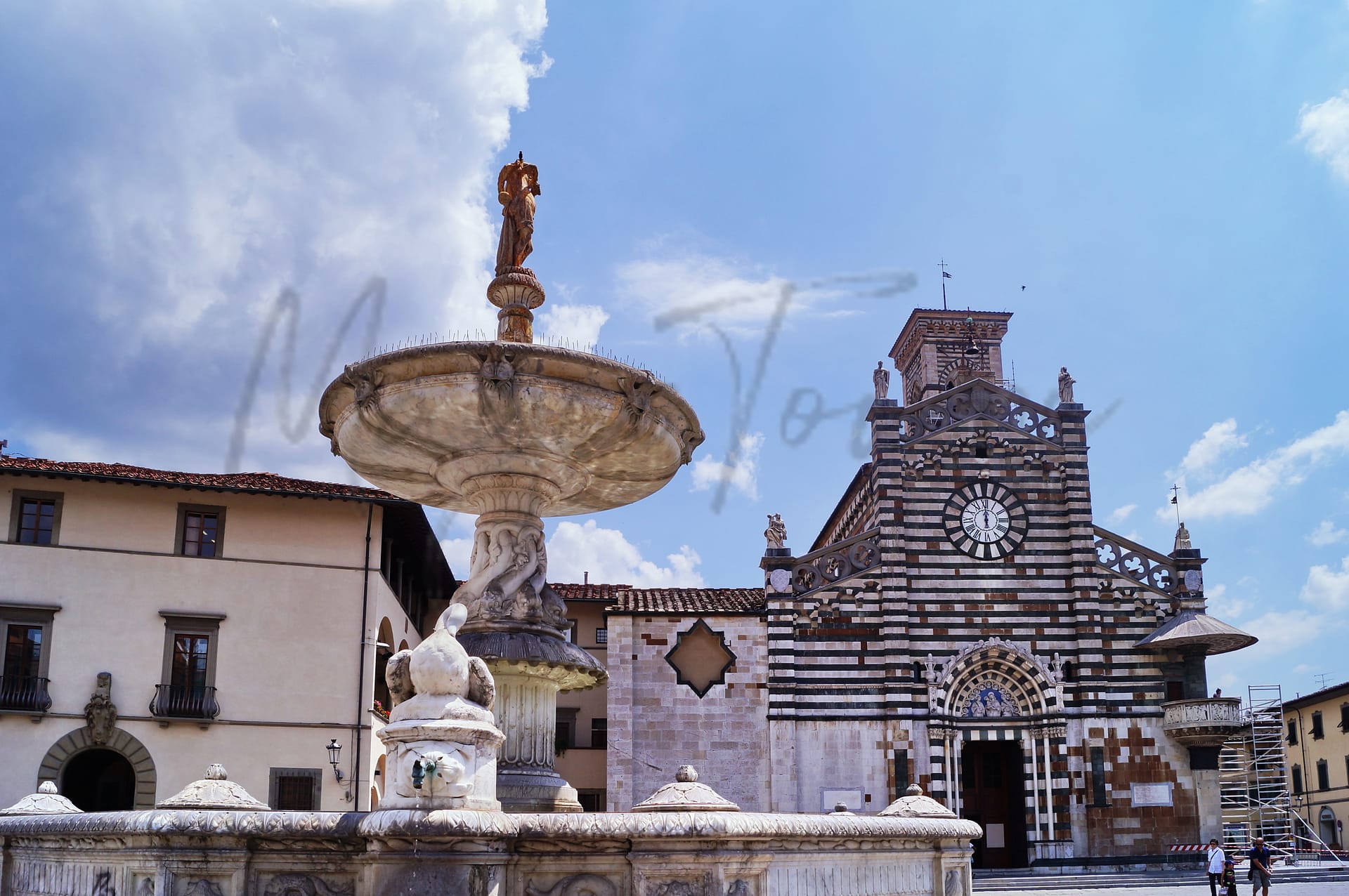
Prato, nestled in the heart of Tuscany, presents a unique blend of cultural heritage and modern living that appeals to foreign expats and retirees. This city is known for its rich textile industry, a vestige of its historic significance, which now integrates contemporary innovations. The strong community spirit is complemented by an increasingly diverse population, making it welcoming for newcomers. Key attractions include the majestic Prato Cathedral, historical sites like the Castello dell’Imperatore, and vibrant markets that reflect the town’s culinary traditions.
Despite its strengths, Prato has challenges that potential residents should consider. The public transport system is often criticized for its inefficiency, and while safety is generally acceptable, crime rates are higher than in other parts of Italy. However, the city’s excellent air quality and proximity to Florence, along with stunning countryside and beaches, offer compensations that many find appealing, creating a balanced lifestyle for those seeking a taste of authentic Italian life.
✅ Pros
– High air quality enhances outdoor living and well-being.
– Rich cultural and historical heritage throughout the town.
– Strong local community fosters integration and social connections.
– Affordable cost of living compared to larger Italian cities.
– Convenient transportation links to Florence and surrounding regions.
– Reliable healthcare services available in the area.
– Pleasant Mediterranean climate ideal for year-round outdoor activities.
– Diverse dining options showcasing regional Tuscan cuisine.
– Expanding educational facilities catering to various age groups.
– Moderate tourism adds vibrancy without overwhelming the town.
❌ Cons
– Healthcare quality could be better; services can be limited.
– Public transport may lack frequency during off-peak hours.
– Limited entertainment options for expats seeking vibrant nightlife.
– Internet connectivity can be inconsistent in some areas.
– Some may find the local dialect challenging to understand.
– Job opportunities may be scarce for non-Italian speakers.
– Local bureaucracy can be slow and frustrating to navigate.
– Weather can be quite hot during summer months.
– Shopping options may not rival larger cities’ variety.
– Cultural events might cater more to locals than expats.
Related Posts
More questions about Prato ? Ask Magic AI.
Our innovative AI assistant is eager to help. Try it out here: