
Elevation
[?]
Elevation of a city refers to the height above sea level at which the city is located, measured in meters.
644
Population
[?]
This is a town's official population, measured each year by the national statistics authority.
3000
Real Population (5km)
[?]
Our "Real Population" metric reflects more accurately a town's real size by including inhabitants in the immediate vicinity of the town's official borders.
105700
Air Quality Rating
[?]
Based on PM10, PM2.5, NO2, SO2, and ozone levels. Higher scores indicate cleaner air.
84
Region
Basilicata
Walkability
Car-Dependent
Housing availability
[?]
Based on total number of properties (sale and rent) classifies housing availability into five categories: low, relativel ylow, medium, relatively high and high.
Low
Avg Download Speed (Mbps) / Avg Upload Speed (Mbps)
64
/ 16
Climate Description
Mild winters, warm summers, ample sunshine, even rainfall, occasional snow; temperate year-round.
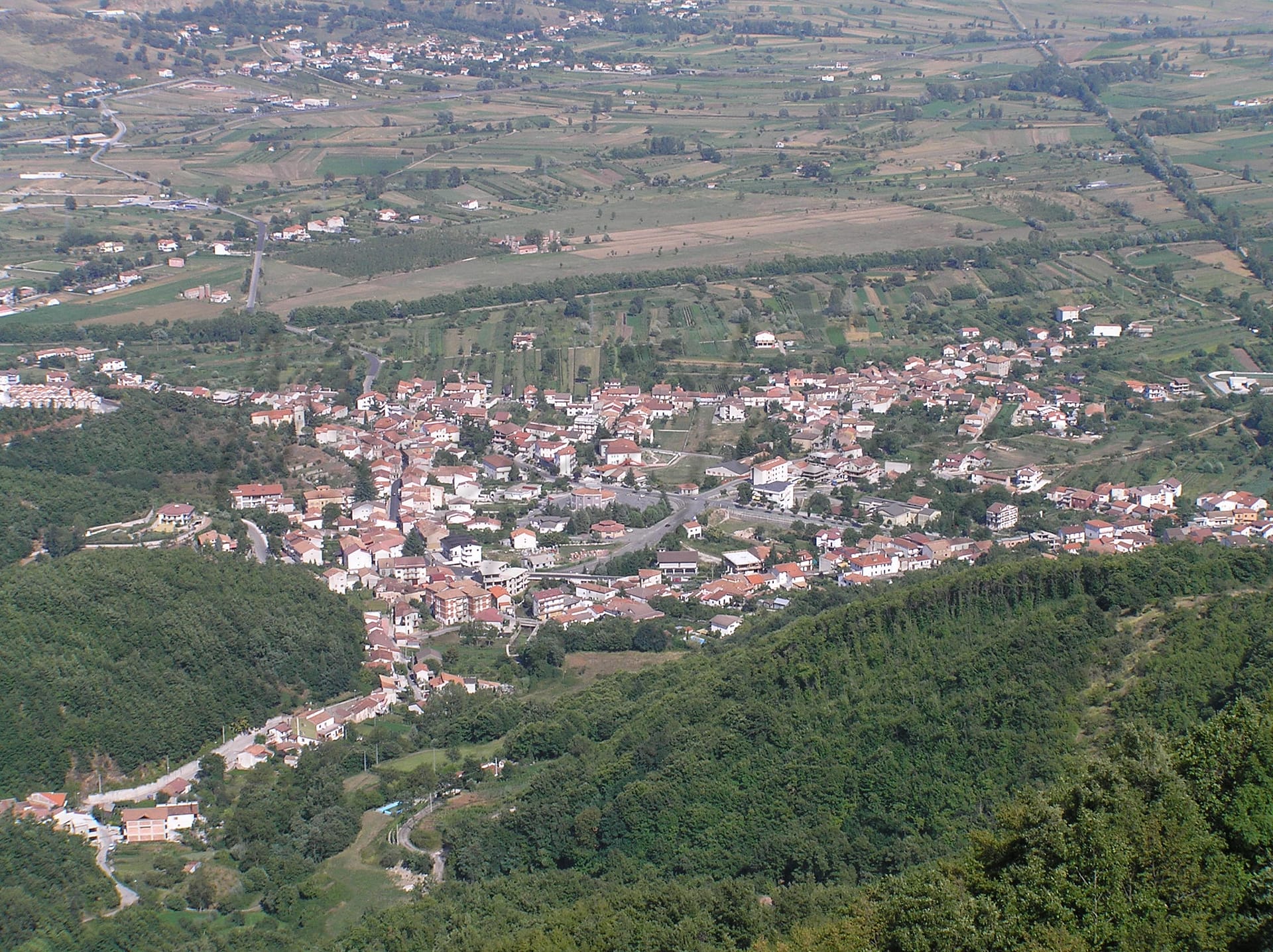
Paterno
Basilicata
Historic town with medieval architecture, outdoor access, local cuisine, but limited transport and healthcare services.
Quality of Life Score
[?]Factors in air quality, amenities, walkability, population, and environmental risks. Higher scores suggest better living conditions.
52
Quality of Infrastructure
[?]Measures internet speed, healthcare access, airports, rail, and walkability. Higher scores mean better connectivity and essential services.
48
Quality of Economy
[?]Based on income, property prices, job availability, and population density. Higher scores indicate stronger economic conditions.
57
Paterno Demographics
Population
[?]
This is a town's official population, measured each year by the national statistics authority.
3000
Real Population (5km band)
[?]
Our "Real Population" metric reflects more accurately a town's real size by including inhabitants in the immediate vicinity of the town's official borders.
105700
Births Per 100 Deaths
20.0
Population Data Source
ISTAT,2023
Estimated Unemployment Rate
Touristy Index
[?]
Calculation of tourist density index for the city, comparing its total tourist number to the overall average tourist number of the region
relative to its own population.The index indicates how a location’s tourist density compares to the average, with values above
100 representing higher-than-average density and values below 100 representing lower-than-average density.
No Data
Income per capita (2023)
[?]
This is an estimation of average income per resident for this town, based on 2023 data from the Italian Ministry of Finance.
16300
Income rank in Italy (2023)
[?]
This is a ranking of the town's average income per resident, against the full list of townships in Italy.
6399 out of 7901
Infrastructure and Connectivity
Create an account to explore more
This content is for Members only | Already a Member? Sign in
Closest Airport
Name
Catania Fontanarossa (Catania)
Connectivity Score
[?]
Measures travel time and service quality of nearby airport stations. Higher scores mean better transport access.
7
Driving Time
23min(s)
Catania Fontanarossa Airport (CTA) is situated in Sicily, Italy, and serves as a significant air travel hub in the Mediterranean. This airport facilitates connections to numerous European cities such as Rome, Munich, Amsterdam, and London, with key routes including Catania to Rome, one of Italy’s busiest. Notably, it accommodates low-cost carriers like Ryanair and Wizz Air, making it accessible for budget travellers and providing direct flights to leisure destinations. Recent terminal expansions enhance passenger experience, although the airport experienced a temporary disruption in July 2023 due to a fire in the terminal.
2nd Closest Airport
Name
Tito Minniti (Reggio Calabria)
Connectivity Score
[?]
Measures travel time and service quality of nearby airport stations. Higher scores mean better transport access.
6
Driving Time
97min(s)
Reggio Calabria Airport, also known as Tito Minniti (IATA: REG), is located in the southern part of Calabria, Italy, approximately 7 km from Reggio Calabria city centre. As one of the busiest airports in Calabria, it offers regular flights within Italy to destinations like Milan Linate and Rome Fiumicino, and international seasonal services to Tirana. Known for serving as an access point for the Strait of Messina region, the airport connects travellers primarily through ITA Airways and Ryanair, catering to both domestic and select European routes.
3rd Closest Airport
Name
Falcone Borsellino (Palermo)
Connectivity Score
[?]
Measures travel time and service quality of nearby airport stations. Higher scores mean better transport access.
9
Driving Time
105min(s)
Falcone Borsellino Airport (PMO) is located in Cinisi, about 35 km northwest of Palermo, the capital of Sicily, Italy. It is the second largest airport on the island, handling over 8 million passengers annually. The airport primarily serves destinations across Europe and offers seasonal flights to New York City. Notable airlines include Aeroitalia, Ryanair, and Volotea, indicating a strong focus on budget-friendly travel options.
Closest Rail
Name
Stazione di Sassano-Teggiano
Connectivity Score
[?]
Measures travel time and service quality of nearby rail stations. Higher scores mean better transport access.
4
Driving Time
31min(s)
Train service at Stazione di Sassano-Teggiano includes regional train lines primarily operated by Trenitalia. Key destinations connected by direct trains from this station include Naples and Salerno. The frequency of departures is limited, with trains typically running a few times per day rather than on an hourly basis. The station does not have high-speed trains, offering mainly regional services.
2nd Closest Rail
Name
Stazione di Montesano-Buonabitacolo
Connectivity Score
[?]
Measures travel time and service quality of nearby rail stations. Higher scores mean better transport access.
5
Driving Time
34min(s)
Train service at Stazione di Montesano-Buonabitacolo offers a variety of connections and services in the Italian rail network.
– **Rail Lines**: The station primarily serves as a stop for regional lines, facilitating access to broader transit networks.
– **Key Destinations**: Key destinations connected directly include Salerno, Naples, and further destinations via connections at major hubs.
– **Train Operators**: The main operators providing services at this station are Trenitalia and Italo.
– **Frequency of Departures**: The frequency of departures varies, but overall it’s typical to have several trains throughout the day, primarily catering to regional travel.
– **Type of Trains**: The station predominantly facilitates regional trains, with no direct high-speed train services terminating here.
3rd Closest Rail
Name
Stazione di Atena Lucana
Connectivity Score
[?]
Measures travel time and service quality of nearby rail stations. Higher scores mean better transport access.
5
Driving Time
34min(s)
Train service at Stazione di Atena Lucana includes the following:
– **Rail Lines that Stop Here**: The main rail line serving the station is the Salerno to Potenza line.
– **Key Destinations Connected by Direct Trains**: Direct train services connect to several key destinations, primarily Salerno and Potenza. Depending on the schedule, connections to Naples may also be available.
– **Train Operators**: The primary train operator for this station is Trenitalia, which handles both regional and some intercity services.
– **Frequency of Departures**: Trains depart from Stazione di Atena Lucana approximately every 30 to 60 minutes during peak times, although frequency can be lower during off-peak hours.
– **Type of Services**: The station mainly offers regional train services, with occasional connections to intercity trains; however, it does not have high-speed train services.
Infrastructure & Amenities
Create an account to explore more
This content is for Members only | Already a Member? Sign in
Healthcare
Create an account to explore more
This content is for Members only | Already a Member? Sign in
Housing & Property Market
Create an account to explore more
This content is for Members only | Already a Member? Sign in
Connectivity & Digital Access
Create an account to explore more
This content is for Members only | Already a Member? Sign in
Education
Create an account to explore more
This content is for Members only | Already a Member? Sign in
Climate & Weather
Create an account to explore more
This content is for Members only | Already a Member? Sign in
Precipitation
[?] Based on daily climate data for precipitation from OPEN-METEO this parameter indicates how a city's annual precipitation compares to others in terms of percentage, with values ranging from 0 (lowest) to 1 (highest). For example, a percentile rank of 0.75 means the city's total precipitation is higher than 75% of other cities.
Low (11th-20th percentile)
Sunshine
Average (41st-50th percentile)
Snowfall
Above Average (51st-60th percentile)
Min Annual Temperature (°C)
[?] This parameter represents the monthly average of daily minimum temperatures for January, based on data from OPEN-METEO.
1.5
Max Annual Temperature (°C)
[?] This parameter represents the monthly average of daily minimum temperatures for January, based on data from OPEN-METEO.
28.5
Climate Description
Paterno, nestled in Italy, offers a climate that balances mild winters and warm summers, ideal for Magic Towns readers and those considering relocation or retirement. The town enjoys an impressive amount of sunshine throughout the year, ensuring plenty of bright days. Rainfall is moderate, distributed fairly evenly across the seasons, maintaining the lush scenery without overwhelming residents or visitors. Winter months occasionally see snowfall, adding a picturesque touch to the landscape without causing major disruptions. Overall, Paterno's climate is quite temperate, making it a comfortable destination year-round.
Annual Temperature Chart (Min)
Error
There was a problem with your SQL connection - Please contact the administrator
There was a problem with your SQL connection - Please contact the administrator
Annual Temperature Chart (Max)
Error
There was a problem with your SQL connection - Please contact the administrator
There was a problem with your SQL connection - Please contact the administrator
Sunny Days By Month
Error
There was a problem with your SQL connection - Please contact the administrator
There was a problem with your SQL connection - Please contact the administrator
Environmental & Air Quality
Create an account to explore more
This content is for Members only | Already a Member? Sign in
Classifications
PM10
[?]
PM10 levels indicate Good air quality at 0–20 µg/m³, Fair at 20–40 µg/m³, Moderate at 40–50 µg/m³, Poor at 50–100 µg/m³, Very Poor at 100–150 µg/m³, and Extremely Poor at 150–1200 µg/m³.
Good
PM2.5
[?]
PM2.5 is Good if PM2.5 levels are between 0–10 µg/m³, Fair between 10–20 µg/m³, Moderate between 20–25 µg/m³, Poor between 25–50 µg/m³, Very Poor between 50–75 µg/m³, and Extremely Poor between 75–800 µg/m³.
Good
NO2
[?]
NO₂ levels are considered Good at 0–40 µg/m³, Fair at 40–90 µg/m³, Moderate at 90–120 µg/m³, Poor at 120–230 µg/m³, Very Poor at 230–340 µg/m³, and Extremely Poor at 340–1000 µg/m³.
Good
SO2
[?]
SO₂ levels indicate Good air quality at 0–100 µg/m³, Fair at 100–200 µg/m³, Moderate at 200–350 µg/m³, Poor at 350–500 µg/m³, Very Poor at 500–750 µg/m³, and Extremely Poor at 750–1250 µg/m³.
Good
O₃
[?]
For O₃, the air is Good at 0–50 µg/m³, Fair at 50–100 µg/m³, Moderate at 100–130 µg/m³, Poor at 130–240 µg/m³, Very Poor at 240–380 µg/m³, and Extremely Poor at 380–800 µg/m³.
Fair
Air Quality Rating
[?]
Based on PM10, PM2.5, NO2, SO2, and ozone levels. Higher scores indicate cleaner air.
84
Air Quality Description
In Paterno, Italy, the air quality stands notably clean and conducive to those seeking a healthier living environment. The presence of particulate matter is minimal, aligning with levels considered good and ensuring a clear, breathable atmosphere. Nitrogen and sulfur dioxide levels are remarkably low, reflecting minimal industrial pollution and excellent maintenance of air purity. Meanwhile, ozone levels are moderate, indicating some fluctuation but nothing significantly detracting from the overall quality of life. This combination ensures that Paterno provides an atmosphere that supports wellness and comfort, ideal for expats and retirees looking to enjoy their days in a serene setting.
In Paterno, Italy, the air quality stands notably clean and conducive to those seeking a healthier living environment. The presence of particulate matter is minimal, aligning with levels considered good and ensuring a clear, breathable atmosphere. Nitrogen and sulfur dioxide levels are remarkably low, reflecting minimal industrial pollution and excellent maintenance of air purity. Meanwhile, ozone levels are moderate, indicating some fluctuation but nothing significantly detracting from the overall quality of life. This combination ensures that Paterno provides an atmosphere that supports wellness and comfort, ideal for expats and retirees looking to enjoy their days in a serene setting.
Town Descriptions
Create an account to explore more
This content is for Members only | Already a Member? Sign in
Getting There
Paterno, located in Basilicata, is accessible primarily via the A19 motorway connecting to the region’s urban centers. The nearest airport is Catania Fontanarossa, approximately 23 minutes away, while Tito Minniti in Reggio Calabria is also within reach. Train stations nearby have modest connectivity scores, reflecting limited public transport options.
Getting Around
Local Cuisine
Paterno, located in the Basilicata region of Italy, showcases a diverse culinary scene deeply rooted in traditional flavors and local agricultural products. The cuisine features iconic dishes such as ‘Spezzatino di agnello’ (lamb stew), ‘Lucanica’ (pork sausage), and ‘Lagane’ (pasta often paired with legumes), with frequent use of local ingredients like Senise peppers, durum wheat, and various cheeses. The dining options consist primarily of traditional restaurants that emphasize local ingredients, with some offering international culinary influences, reflecting a blend of Mediterranean flavors. While Paterno itself may not host Michelin-starred establishments, the surrounding region includes notable Michelin-starred restaurants, particularly in nearby Matera. These restaurants focus on innovative interpretations of local cuisine, contributing to the flourishing gastronomic reputation of Basilicata.
Shopping Overview
The city offers a diverse range of shopping options catering to various needs. Supermarkets are widely available for everyday grocery shopping. For a more extensive retail experience, several shopping centres and malls host numerous brands, alongside specialty shops offering local goods and artisanal products. The shopping scene includes both modern retail complexes and traditional markets, providing a blend of convenience and cultural experiences. Expats and retirees can find everything from fresh produce to fashion within easy reach.
Neighborhoods
Green Areas and Parks
Paterno, located in the Basilicata region of Italy, offers notable outdoor opportunities such as the Paterno – Villa D’Agri trail. This 33.6 km trail is favored for bicycling, providing a moderate challenge primarily along roadways with an estimated completion time of about seven hours. The trail is recommended for both cycling and walking, featuring scenic views as it crosses the Agri river. Additionally, the Parco Fluviale dell’Agri provides a green space for various outdoor activities in the area, complementing the region’s offerings for nature enthusiasts and retirees seeking active lifestyles.
✅ Pros
– Rich cultural and historical heritage to explore and enjoy.
– Beautiful natural surroundings ideal for outdoor activities.
– Mild climate, perfect for year-round outdoor living.
– Strong community ties and friendly local residents.
– Opportunities for integration into Italian culture and lifestyle.
– Access to healthcare facilities, although quality may vary.
– Reasonable cost of living compared to larger cities.
– Growing potential for local businesses and services.
– Adequate air quality for comfortable living conditions.
– Scenic landscapes offering tranquility and a slower pace of life.
❌ Cons
– Healthcare quality may not meet expectations for serious conditions.
– Public transportation options can be limited and inconvenient.
– Higher unemployment rates than the national average can be concerning.
– Infrastructure development may feel outdated or lacking.
– Internet speeds could frustrate those needing fast connectivity.
– Educational facilities may not cater to all international standards.
– Limited tourist infrastructure might feel isolating for newcomers.
– Seasonal weather can be unpredictably chilly or wet.
– Local businesses may struggle to meet diverse expat needs.
– Cost of living may not always equate to quality amenities.
FAQs
Summary
Paterno, located in the heart of Basilicata, draws foreign expats and retirees with its blend of quaint charm and cultural richness. This historic town, characterized by its medieval architecture and cobblestone streets, offers a glimpse into Italy’s diverse past. Key attractions include the striking Church of Santa Maria Assunta and the nearby natural beauty of the Apennines, perfect for outdoor enthusiasts. Paterno’s culinary scene is notable, with local industries revolving around agriculture and traditional food production, providing fresh, authentic experiences.
However, potential challenges exist. The town’s public transport options are limited, which may impact mobility for those accustomed to city life. While healthcare services are adequate, they may not meet the expectations of those from larger urban centers. Expats may find some recreational options lacking, leading to a quieter lifestyle. Nevertheless, Paterno’s serene environment and welcoming community make it an intriguing choice for a slower-paced life.
✅ Pros
– Rich cultural and historical heritage to explore and enjoy.
– Beautiful natural surroundings ideal for outdoor activities.
– Mild climate, perfect for year-round outdoor living.
– Strong community ties and friendly local residents.
– Opportunities for integration into Italian culture and lifestyle.
– Access to healthcare facilities, although quality may vary.
– Reasonable cost of living compared to larger cities.
– Growing potential for local businesses and services.
– Adequate air quality for comfortable living conditions.
– Scenic landscapes offering tranquility and a slower pace of life.
❌ Cons
– Healthcare quality may not meet expectations for serious conditions.
– Public transportation options can be limited and inconvenient.
– Higher unemployment rates than the national average can be concerning.
– Infrastructure development may feel outdated or lacking.
– Internet speeds could frustrate those needing fast connectivity.
– Educational facilities may not cater to all international standards.
– Limited tourist infrastructure might feel isolating for newcomers.
– Seasonal weather can be unpredictably chilly or wet.
– Local businesses may struggle to meet diverse expat needs.
– Cost of living may not always equate to quality amenities.
Related Posts
More questions about Paterno ? Ask Magic AI.
Our innovative AI assistant is eager to help. Try it out here: