
Elevation
[?]
Elevation of a city refers to the height above sea level at which the city is located, measured in meters.
192
Population
[?]
This is a town's official population, measured each year by the national statistics authority.
16500
Real Population (5km)
[?]
Our "Real Population" metric reflects more accurately a town's real size by including inhabitants in the immediate vicinity of the town's official borders.
130400
Air Quality Rating
[?]
Based on PM10, PM2.5, NO2, SO2, and ozone levels. Higher scores indicate cleaner air.
82
Region
Veneto
Walkability
Very Walkable
Housing availability
[?]
Based on total number of properties (sale and rent) classifies housing availability into five categories: low, relativel ylow, medium, relatively high and high.
Relatively Low
Avg Download Speed (Mbps) / Avg Upload Speed (Mbps)
135
/ 54
Climate Description
Pleasant summers and gentle winters define the area, with plentiful sun and moderate rainfall. Light snowfall also occurs.
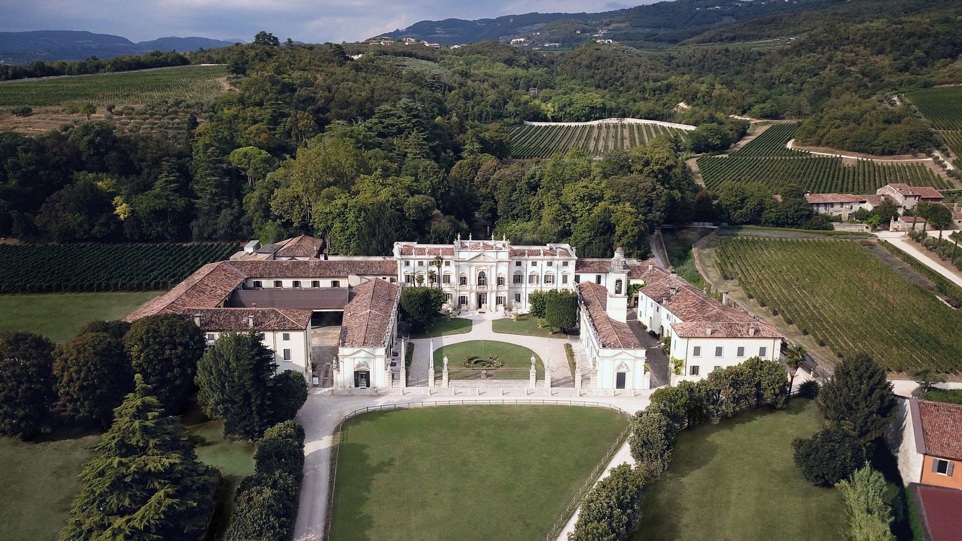
Negrar di Valpolicella
Veneto
Renowned for Valpolicella wine, this comune features historic sites and lush landscapes, appealing to enophiles and lovers of rich cuisine and culture.
Quality of Life Score
[?]Factors in air quality, amenities, walkability, population, and environmental risks. Higher scores suggest better living conditions.
91
Quality of Infrastructure
[?]Measures internet speed, healthcare access, airports, rail, and walkability. Higher scores mean better connectivity and essential services.
100
Quality of Economy
[?]Based on income, property prices, job availability, and population density. Higher scores indicate stronger economic conditions.
66
Negrar di Valpolicella Demographics
Population
[?]
This is a town's official population, measured each year by the national statistics authority.
16500
Real Population (5km band)
[?]
Our "Real Population" metric reflects more accurately a town's real size by including inhabitants in the immediate vicinity of the town's official borders.
130400
Births Per 100 Deaths
50.0
Population Data Source
ISTAT,2023
Estimated Unemployment Rate
Touristy Index
[?]
Calculation of tourist density index for the city, comparing its total tourist number to the overall average tourist number of the region
relative to its own population.The index indicates how a location’s tourist density compares to the average, with values above
100 representing higher-than-average density and values below 100 representing lower-than-average density.
Some Tourism
Income per capita (2023)
[?]
This is an estimation of average income per resident for this town, based on 2023 data from the Italian Ministry of Finance.
23800
Income rank in Italy (2023)
[?]
This is a ranking of the town's average income per resident, against the full list of townships in Italy.
1098 out of 7901
Infrastructure and Connectivity
Create an account to explore more
This content is for Members only | Already a Member? Sign in
Infrastructure & Amenities
Create an account to explore more
This content is for Members only | Already a Member? Sign in
Within 10km
Auto Repair Shops
217
Bars
74
Cafes
54
Cinemas
2
Dentists
59
Golf Courses
1
Gyms
65
Health Clinics
16
Hiking Trails
27
Historical Sites
129
Libraries
8
Museums
9
Parks
15
Pharmacies
39
Restaurants
125
Shopping Centres
8
Supermarkets
71
Spas
99
Beach
Name
Driving Distance
Water Quality Rating
Mountain Resort
Name
Monte Baldo - Malcesine/Prà Alpesina
Driving Distance
58.0mins
Healthcare
Create an account to explore more
This content is for Members only | Already a Member? Sign in
Healthcare Score
[?]
Evaluates hospital/clinic access, drive time to care, and regional quality rankings. Higher scores mean better healthcare.
55.0
Nearest Hospital Name
Sacro Cuore
Drive Time to Nearest Hospital
3 minutes
Hospitals and Clinics Within 10km
4
Healthcare Quality Description
In this area of Veneto, healthcare services exhibit moderate efficiency, with average overall indicators by national standards. Local hospital care ranks low, suggesting limitations in immediate services. Emergency cardiac care is relatively efficient, yet breast cancer treatments often bypass minimally invasive methods. Orthopaedic concerns are resolved promptly, with most bone fractures managed swiftly. Patient outcomes post-surgery are favourable, indicating effective short-stay recoveries. However, readmissions following a heart attack are somewhat frequent, as are the instances post-heart failure. Prospective residents may find varying levels of care quality, necessitating consideration of specific medical needs prior to relocation.
Local Public Healthcare Provider
AZIENDA ULSS N. 9 SCALIGERA
Safety
Seismic Zone (risk of earthquakes)
[?]
Official seismic zones classify areas based on earthquake risk.
Moderate Earthquake Risk
Road Accidents Rate per 10k Inhabitants
[?]
Calculation of road accidents per 10,000 people based on the number of deaths and injuries registered in roads for year 2022 for the city.
15
Percentage of Population at Landslide Risk
[?] Percentage of the population in high or moderate landslide risk zones. Higher values indicate greater environmental risk.
Percentage of Population at Flood Risk
[?] Percentage of the population in high or moderate flood risk zones. Higher values indicate greater environmental risk.
Car Insurance Price Index
[?]
The car insurance price index is a measure of how a city's average car insurance premium compares to the national average,
expressed as a percentage. A value of 100 indicates that the city's premium is equal to the national average.
Values above 100 show higher premiums, while values below 100 show lower premiums.
96.851
Housing & Property Market
Create an account to explore more
This content is for Members only | Already a Member? Sign in
Housing availability
[?]
Based on total number of properties (sale and rent) classifies housing availability into five categories: low, relativel ylow, medium, relatively high and high.
Relatively Low
Property Prices per m²
[?]
Calculation of property sale prices per square meter for apartments, houses in the city.
Median (50th Percentile): The midpoint price, where half the values are above and half below.
First Quartile (25th Percentile): The price below which 25% of properties fall.
Third Quartile (75th Percentile): The price below which 75% of properties fall.
First Quartile
1542
Median
2312
Third Quartile
2875
Connectivity & Digital Access
Create an account to explore more
This content is for Members only | Already a Member? Sign in
Walkability Description
Very Walkable
Avg Download Speed (Mbps)
135
Fast Download Speed (Mbps)
217
Slow Download Speed (Mbps)
55
Education
Create an account to explore more
This content is for Members only | Already a Member? Sign in
Avg Schools Ranking (All Criteria)
[?]
This ranking shows in which decile the town's public schools fall while looking at all the indicators provided by the Italian Ministry of Education for the most recent available year. Note that figures are only provided by the ministry at the school catchment area level, and therefore several schools may be grouped together.
Bottom 20%
Avg Schools Ranking (Standardised Tests)
[?]
This ranking shows in which decile the town's public schools fall while looking the students' results in national standardised tests. The data is provided by the Italian Ministry of Education for the most recent available year.
Bottom 10%
Counts of School
Error
There was a problem with your SQL connection - Please contact the administrator
There was a problem with your SQL connection - Please contact the administrator
Climate & Weather
Create an account to explore more
This content is for Members only | Already a Member? Sign in
Precipitation
[?] Based on daily climate data for precipitation from OPEN-METEO this parameter indicates how a city's annual precipitation compares to others in terms of percentage, with values ranging from 0 (lowest) to 1 (highest). For example, a percentile rank of 0.75 means the city's total precipitation is higher than 75% of other cities.
Average (41st-50th percentile)
Sunshine
Somewhat Low (21st-30th percentile)
Snowfall
Average (41st-50th percentile)
Min Annual Temperature (°C)
[?] This parameter represents the monthly average of daily minimum temperatures for January, based on data from OPEN-METEO.
0.2
Max Annual Temperature (°C)
[?] This parameter represents the monthly average of daily minimum temperatures for January, based on data from OPEN-METEO.
28.2
Climate Description
In Negrar di Valpolicella, the climate is characterized by its distinct seasonal changes. The winter months often bear a light dusting of snow, creating a picturesque scene without significant disruptions. Summers in Negrar di Valpolicella are pleasantly warm but rarely scorching, allowing for comfortable enjoyment of the outdoors and local vineyards. Transition seasons, spring and autumn, are marked by a moderate climate, balancing warmth and coolness. The town enjoys a considerable amount of sun throughout the year, making it an ideal location for sun seekers. Rainfall is well-distributed across the months, contributing to the lush landscapes that define the region.
Annual Temperature Chart (Min)
Error
There was a problem with your SQL connection - Please contact the administrator
There was a problem with your SQL connection - Please contact the administrator
Annual Temperature Chart (Max)
Error
There was a problem with your SQL connection - Please contact the administrator
There was a problem with your SQL connection - Please contact the administrator
Sunny Days By Month
Error
There was a problem with your SQL connection - Please contact the administrator
There was a problem with your SQL connection - Please contact the administrator
Environmental & Air Quality
Create an account to explore more
This content is for Members only | Already a Member? Sign in
Classifications
PM10
[?]
PM10 levels indicate Good air quality at 0–20 µg/m³, Fair at 20–40 µg/m³, Moderate at 40–50 µg/m³, Poor at 50–100 µg/m³, Very Poor at 100–150 µg/m³, and Extremely Poor at 150–1200 µg/m³.
Fair
PM2.5
[?]
PM2.5 is Good if PM2.5 levels are between 0–10 µg/m³, Fair between 10–20 µg/m³, Moderate between 20–25 µg/m³, Poor between 25–50 µg/m³, Very Poor between 50–75 µg/m³, and Extremely Poor between 75–800 µg/m³.
Fair
NO2
[?]
NO₂ levels are considered Good at 0–40 µg/m³, Fair at 40–90 µg/m³, Moderate at 90–120 µg/m³, Poor at 120–230 µg/m³, Very Poor at 230–340 µg/m³, and Extremely Poor at 340–1000 µg/m³.
Good
SO2
[?]
SO₂ levels indicate Good air quality at 0–100 µg/m³, Fair at 100–200 µg/m³, Moderate at 200–350 µg/m³, Poor at 350–500 µg/m³, Very Poor at 500–750 µg/m³, and Extremely Poor at 750–1250 µg/m³.
Good
O₃
[?]
For O₃, the air is Good at 0–50 µg/m³, Fair at 50–100 µg/m³, Moderate at 100–130 µg/m³, Poor at 130–240 µg/m³, Very Poor at 240–380 µg/m³, and Extremely Poor at 380–800 µg/m³.
Fair
Air Quality Rating
[?]
Based on PM10, PM2.5, NO2, SO2, and ozone levels. Higher scores indicate cleaner air.
82
Air Quality Description
Negrar di Valpolicella, situated in Italy’s verdant heart, offers consistently fair air quality to its residents. Resting amid traditional vineyards, this locale experiences moderate pollution levels from particulate matter, both fine and coarse, though they generally remain within acceptable limits. The air is notably cleaner when it comes to nitrogen and sulfur oxides, hinting at a minimal industrial footprint and steady management of vehicular emissions. Ozone levels are moderate, reflecting typical urban-rural fringes. Ideal for those seeking a balance between pastoral charm and accessible urban amenities, Negrar di Valpolicella maintains an atmosphere that supports both leisure and daily activities.
Negrar di Valpolicella, situated in Italy’s verdant heart, offers consistently fair air quality to its residents. Resting amid traditional vineyards, this locale experiences moderate pollution levels from particulate matter, both fine and coarse, though they generally remain within acceptable limits. The air is notably cleaner when it comes to nitrogen and sulfur oxides, hinting at a minimal industrial footprint and steady management of vehicular emissions. Ozone levels are moderate, reflecting typical urban-rural fringes. Ideal for those seeking a balance between pastoral charm and accessible urban amenities, Negrar di Valpolicella maintains an atmosphere that supports both leisure and daily activities.
Town Descriptions
Create an account to explore more
This content is for Members only | Already a Member? Sign in
Getting There
Negrar di Valpolicella offers solid transport connections, with Valerio Catullo Airport in Verona and Montichiari Airport in Brescia as the nearest air travel options. Road access is facilitated by connections to the A22 motorway, enhancing accessibility to regional and national destinations. Local train stations provide additional connectivity, rated favorably for their service quality.
Getting Around
The area is accessible by bus from Verona, providing a direct route to explore its scenic vineyards and historic sites. Ample parking facilities cater to visitors renting cars, ideal for navigating the picturesque terrain at their leisure.
Local Cuisine
Negrar di Valpolicella offers a rich and diverse culinary scene that showcases traditional Veronese cuisine alongside a selection of international dining options. The local culinary specialties include homemade dishes such as freshly made lasagnette, succulent grilled meats, and porchetta alla romana, highlighting the region’s emphasis on high-quality, locally sourced ingredients. The town features a variety of restaurants that cater to both traditional tastes and modern culinary trends, creating a vibrant dining atmosphere. Notably, Negrar is home to Michelin-starred establishments like Locanda ‘800, which underscores the area’s commitment to fine dining. Overall, the culinary landscape in Negrar di Valpolicella blends local heritage with contemporary influences, making it a compelling destination for food enthusiasts.
Shopping Overview
Negrar di Valpolicella offers diverse shopping options, catering to everyday needs and unique offerings. The area includes supermarkets for daily grocery shopping, speciality and gift shops providing local wines and artisanal products, and markets selling fresh produce and goods from nearby farms. While there are no large shopping centres in the immediate vicinity, residents can access outlet stores and larger retail options in nearby Verona, ensuring a comprehensive retail experience. This blend of local and accessible broader shopping venues supports a balanced lifestyle for expats and retirees.
Neighborhoods
Green Areas and Parks
Negrar di Valpolicella offers several hiking options suitable for varying skill levels. The Valpolicella Wine Tour is a 7.7-mile moderate trail providing scenic views and elevation gain of 1,505 feet. For a longer hike, Montecchio – Siresol – Preperchiusa spans 8.6 miles. Easier options include Prada Bassa – La Ca’ via Strada dei Monti, a 3-mile trail that is well-rated. The Giro Vallata di Negrar covers 5.2 miles and provides a moderate challenge. Each path brings walkers through vineyards and picturesque landscapes, ideal for those seeking to explore the region’s natural beauty [source](https://www.alltrails.com/italy/veneto/negrar).
✅ Pros
– Excellent healthcare services available locally and regionally.
– Well-connected transportation system for easy travel.
– Pleasant Mediterranean climate with mild winters and warm summers.
– Rich cultural and historical backdrop to explore and enjoy.
– Strong infrastructure supporting daily living and accessibility.
– Low unemployment rate, promoting economic stability and growth.
– Opportunities for integration in a friendly, welcoming community.
– Good air quality enhances overall quality of life.
– Nearby tourist attractions enhance lifestyle and leisure options.
– Local educational facilities support lifelong learning and development.
❌ Cons
– Limited variety in dining and entertainment options available locally.
– Some healthcare services may experience long waiting times.
– Internet connectivity can be slower than in larger cities.
– Public transport schedules may lack frequency during off-peak hours.
– Occasional tourist crowds can disrupt the peaceful atmosphere.
– Limited job opportunities for non-Italian speakers in specialized fields.
– Smaller town may feel isolated for those seeking vibrant nightlife.
– Winters can still be quite chilly, despite the mild reputation.
– Cultural events may not be as frequent as in larger cities.
– Limited shopping options might require travel to nearby towns.
FAQs
Summary
Nestled in the picturesque Veneto region of Italy, Negrar di Valpolicella is a comune renowned for its viticulture, particularly the production of the robust Valpolicella wine. This charming municipality is part of the province of Verona and lies encompassed by lush vineyards and historic sites that offer glimpses into its rich heritage. It serves not only as a haven for enophiles but also as a gateway to exploring natural landscapes, including idyllic valleys and placid rivers that define its terrain. The locale’s architecture underscores a deep historical narrative, showcasing ancient churches and villas that date back centuries. While primarily celebrated for its wine production, Negrar di Valpolicella also boasts a robust agricultural sector, contributing to a vibrant local cuisine that attracts gastronomy enthusiasts from around the globe.
✅ Pros
– Excellent healthcare services available locally and regionally.
– Well-connected transportation system for easy travel.
– Pleasant Mediterranean climate with mild winters and warm summers.
– Rich cultural and historical backdrop to explore and enjoy.
– Strong infrastructure supporting daily living and accessibility.
– Low unemployment rate, promoting economic stability and growth.
– Opportunities for integration in a friendly, welcoming community.
– Good air quality enhances overall quality of life.
– Nearby tourist attractions enhance lifestyle and leisure options.
– Local educational facilities support lifelong learning and development.
❌ Cons
– Limited variety in dining and entertainment options available locally.
– Some healthcare services may experience long waiting times.
– Internet connectivity can be slower than in larger cities.
– Public transport schedules may lack frequency during off-peak hours.
– Occasional tourist crowds can disrupt the peaceful atmosphere.
– Limited job opportunities for non-Italian speakers in specialized fields.
– Smaller town may feel isolated for those seeking vibrant nightlife.
– Winters can still be quite chilly, despite the mild reputation.
– Cultural events may not be as frequent as in larger cities.
– Limited shopping options might require travel to nearby towns.
Related Posts
More questions about Negrar di Valpolicella ? Ask Magic AI.
Our innovative AI assistant is eager to help. Try it out here: