
Elevation
[?]
Elevation of a city refers to the height above sea level at which the city is located, measured in meters.
107
Population
[?]
This is a town's official population, measured each year by the national statistics authority.
15500
Real Population (5km)
[?]
Our "Real Population" metric reflects more accurately a town's real size by including inhabitants in the immediate vicinity of the town's official borders.
40900
Air Quality Rating
[?]
Based on PM10, PM2.5, NO2, SO2, and ozone levels. Higher scores indicate cleaner air.
82
Region
Lombardia
Walkability
Very Walkable
Housing availability
[?]
Based on total number of properties (sale and rent) classifies housing availability into five categories: low, relativel ylow, medium, relatively high and high.
Medium
Avg Download Speed (Mbps) / Avg Upload Speed (Mbps)
188
/ 128
Climate Description
Temperate climate, warm summers, mild winters, moderate rainfall, year-round sunshine.
Mortara
Lombardia
Located in Lombardy, the town is known for rice production, historical landmarks, and cultural festivals.
Quality of Life Score
[?]Factors in air quality, amenities, walkability, population, and environmental risks. Higher scores suggest better living conditions.
80
Quality of Infrastructure
[?]Measures internet speed, healthcare access, airports, rail, and walkability. Higher scores mean better connectivity and essential services.
78
Quality of Economy
[?]Based on income, property prices, job availability, and population density. Higher scores indicate stronger economic conditions.
82
Mortara Demographics
Population
[?]
This is a town's official population, measured each year by the national statistics authority.
15500
Real Population (5km band)
[?]
Our "Real Population" metric reflects more accurately a town's real size by including inhabitants in the immediate vicinity of the town's official borders.
40900
Births Per 100 Deaths
50.0
Population Data Source
ISTAT,2023
Estimated Unemployment Rate
Touristy Index
[?]
Calculation of tourist density index for the city, comparing its total tourist number to the overall average tourist number of the region
relative to its own population.The index indicates how a location’s tourist density compares to the average, with values above
100 representing higher-than-average density and values below 100 representing lower-than-average density.
Not Touristic
Income per capita (2023)
[?]
This is an estimation of average income per resident for this town, based on 2023 data from the Italian Ministry of Finance.
22400
Income rank in Italy (2023)
[?]
This is a ranking of the town's average income per resident, against the full list of townships in Italy.
2253 out of 7901
Infrastructure and Connectivity
Create an account to explore more
This content is for Members only | Already a Member? Sign in
Closest Airport
Name
Malpensa (Milan)
Connectivity Score
[?]
Measures travel time and service quality of nearby airport stations. Higher scores mean better transport access.
10
Driving Time
45min(s)
Milan Malpensa Airport (MXP) is located near Milan, Italy, and is the second largest and busiest airport in the country. Handling 28.5 million passengers, the airport connects to around 195 destinations worldwide, serving as a major hub for EasyJet. Key routes include flights to New York, London, Dubai, and Istanbul, making it a significant international gateway. Notable for its effective connectivity with Milan’s city centre via the Malpensa Express, the airport caters extensively to travellers heading to diverse European, American, and Asian destinations.
2nd Closest Airport
Name
Linate (Milan)
Connectivity Score
[?]
Measures travel time and service quality of nearby airport stations. Higher scores mean better transport access.
7
Driving Time
48min(s)
Milan Linate Airport (LIN), situated in Segrate and Peschiera Borromeo in Lombardy, Italy, serves around 10.6 million passengers annually. It focuses on flights within Europe and the United Kingdom, serving as a hub for ITA Airways. The airport offers convenient connections to popular destinations such as Rome, Cagliari, and Paris, making it an accessible choice for travellers seeking direct European flights.
3rd Closest Airport
Name
Torino Airport (Turin)
Connectivity Score
[?]
Measures travel time and service quality of nearby airport stations. Higher scores mean better transport access.
7
Driving Time
68min(s)
Turin Airport, also called Turin-Caselle Airport, is situated in Caselle Torinese, approximately 16 km north-west of Turin, Italy. In 2022, it catered to over 4 million passengers with significant connections to international destinations including Frankfurt, Barcelona, and London, and domestic routes like Rome and Naples. The airport hosts a mix of European carriers, providing travellers with connectivity suitable for both business and leisure, featuring mainline and budget airlines.
Closest Rail
Name
Stazione di Mortara
Connectivity Score
[?]
Measures travel time and service quality of nearby rail stations. Higher scores mean better transport access.
7
Driving Time
4min(s)
Train service at Stazione di Mortara provides access to various regional lines, including the Mortara-Milano Regional line and the Mortara-Alessandria Regional line. Key destinations connected by direct trains include Milano Porta Genova, Novara, Pavia, Milan, Alessandria, and Vercelli. The primary train operators servicing this station are Trenitalia and Trenord. Departures are typically frequent, with trains running every 30 to 60 minutes depending on the route and time of day. The service mainly consists of regional trains, with no high-speed train services available at this station.
2nd Closest Rail
Name
Stazione di Gambolò-Remondò
Connectivity Score
[?]
Measures travel time and service quality of nearby rail stations. Higher scores mean better transport access.
4
Driving Time
6min(s)
Train service at Stazione di Gambolò-Remondò is primarily served by regional train services. The key rail line that stops at this station is the Milan-Pavia line. Direct train services connect Gambolò-Remondò to notable destinations such as Pavia and Milan. The main train operator for services here is Trenitalia, which provides regional connections. Trains depart from Gambolò-Remondò approximately every 30 to 60 minutes throughout the day. The station primarily offers regional train services rather than high-speed options, making it a convenient choice for local travel.
3rd Closest Rail
Name
Stazione di Parona Lomellina
Connectivity Score
[?]
Measures travel time and service quality of nearby rail stations. Higher scores mean better transport access.
4
Driving Time
8min(s)
Train service at Stazione di Parona Lomellina includes the following details:
– **Rail lines that stop here**: Primarily the regional rail service operated by Trenord on the S9 line connecting with nearby cities.
– **Key destinations connected by direct trains**: Major connections include Milano Porta Genova, where trains proceed to and from various central northern Italian destinations.
– **Train operators**: The main operator is Trenord.
– **Frequency of departures**: Trains operate approximately every 30 minutes during peak times, with reduced frequency during off-peak hours.
– **High-speed trains**: There are no high-speed trains, and service is mainly regional, focusing on local commuter traffic.
Infrastructure & Amenities
Create an account to explore more
This content is for Members only | Already a Member? Sign in
Healthcare
Create an account to explore more
This content is for Members only | Already a Member? Sign in
Housing & Property Market
Create an account to explore more
This content is for Members only | Already a Member? Sign in
Connectivity & Digital Access
Create an account to explore more
This content is for Members only | Already a Member? Sign in
Education
Create an account to explore more
This content is for Members only | Already a Member? Sign in
Climate & Weather
Create an account to explore more
This content is for Members only | Already a Member? Sign in
Precipitation
[?] Based on daily climate data for precipitation from OPEN-METEO this parameter indicates how a city's annual precipitation compares to others in terms of percentage, with values ranging from 0 (lowest) to 1 (highest). For example, a percentile rank of 0.75 means the city's total precipitation is higher than 75% of other cities.
Above Average (51st-60th percentile)
Sunshine
Below Average (31st-40th percentile)
Snowfall
Above Average (51st-60th percentile)
Min Annual Temperature (°C)
[?] This parameter represents the monthly average of daily minimum temperatures for January, based on data from OPEN-METEO.
-0.8
Max Annual Temperature (°C)
[?] This parameter represents the monthly average of daily minimum temperatures for January, based on data from OPEN-METEO.
29.8
Climate Description
Mortara, Italy, enjoys a temperate climate throughout the year. The summers are typically warm without becoming overly hot, which makes it pleasant for exploring the surrounding countryside or indulging in outdoor activities. In the winter, the region experiences mild cold snaps, but extreme cold is rare, with only modest amounts of snowfall occasionally blanketing the town. This climate ensures that retirees and expats from colder climates will find Mortara a comfortable place to reside, offering a respite from harsh winters. The area benefits substantially from sunshine year-round, contributing to cheerful, bright days ideal for those who revel in outdoor leisure or gardening. Consistent yet moderate rainfall supports lush landscapes and agriculture without leading to severe weather disruptions.
Annual Temperature Chart (Min)
Error
There was a problem with your SQL connection - Please contact the administrator
There was a problem with your SQL connection - Please contact the administrator
Annual Temperature Chart (Max)
Error
There was a problem with your SQL connection - Please contact the administrator
There was a problem with your SQL connection - Please contact the administrator
Sunny Days By Month
Error
There was a problem with your SQL connection - Please contact the administrator
There was a problem with your SQL connection - Please contact the administrator
Environmental & Air Quality
Create an account to explore more
This content is for Members only | Already a Member? Sign in
Classifications
PM10
[?]
PM10 levels indicate Good air quality at 0–20 µg/m³, Fair at 20–40 µg/m³, Moderate at 40–50 µg/m³, Poor at 50–100 µg/m³, Very Poor at 100–150 µg/m³, and Extremely Poor at 150–1200 µg/m³.
Fair
PM2.5
[?]
PM2.5 is Good if PM2.5 levels are between 0–10 µg/m³, Fair between 10–20 µg/m³, Moderate between 20–25 µg/m³, Poor between 25–50 µg/m³, Very Poor between 50–75 µg/m³, and Extremely Poor between 75–800 µg/m³.
Fair
NO2
[?]
NO₂ levels are considered Good at 0–40 µg/m³, Fair at 40–90 µg/m³, Moderate at 90–120 µg/m³, Poor at 120–230 µg/m³, Very Poor at 230–340 µg/m³, and Extremely Poor at 340–1000 µg/m³.
Good
SO2
[?]
SO₂ levels indicate Good air quality at 0–100 µg/m³, Fair at 100–200 µg/m³, Moderate at 200–350 µg/m³, Poor at 350–500 µg/m³, Very Poor at 500–750 µg/m³, and Extremely Poor at 750–1250 µg/m³.
Good
O₃
[?]
For O₃, the air is Good at 0–50 µg/m³, Fair at 50–100 µg/m³, Moderate at 100–130 µg/m³, Poor at 130–240 µg/m³, Very Poor at 240–380 µg/m³, and Extremely Poor at 380–800 µg/m³.
Fair
Air Quality Rating
[?]
Based on PM10, PM2.5, NO2, SO2, and ozone levels. Higher scores indicate cleaner air.
82
Air Quality Description
Mortara, Italy boasts an air quality profile that supports a healthy and comfortable lifestyle, particularly appealing to those considering relocation in their later years. The atmosphere in Mortara is marked by fair levels of particulate matter, both PM10 and PM2.5, ensuring that the air remains breathable without significant pollutants typical of more industrial environments. Nitrogen dioxide and sulphur dioxide are present at low, satisfactory concentrations, contributing positively to the local air cleanliness. The ozone level, while fair, remains within a moderate range conducive to outdoor activities. Ideal for expatriates and retirees, Mortara offers a commendable balance in air quality standards.
Mortara, Italy boasts an air quality profile that supports a healthy and comfortable lifestyle, particularly appealing to those considering relocation in their later years. The atmosphere in Mortara is marked by fair levels of particulate matter, both PM10 and PM2.5, ensuring that the air remains breathable without significant pollutants typical of more industrial environments. Nitrogen dioxide and sulphur dioxide are present at low, satisfactory concentrations, contributing positively to the local air cleanliness. The ozone level, while fair, remains within a moderate range conducive to outdoor activities. Ideal for expatriates and retirees, Mortara offers a commendable balance in air quality standards.
Town Descriptions
Create an account to explore more
This content is for Members only | Already a Member? Sign in
Getting There
Mortara is accessible via the A4 and A7 highways, linking it to key urban centers. The nearest airports, Malpensa and Linate, enhance its connectivity. Local train stations provide options for regional travel, reflecting a solid infrastructure rating, facilitating movement within Lombardy and beyond.
Getting Around
Local Cuisine
Mortara, situated in Lombardy, boasts a culinary scene that is rich in tradition and flavors. The standout local delicacy is Goose Salami, renowned for its quality and distinct taste. This dish exemplifies the region’s heartiness and reliance on preserved meats, which also includes popular items like Bresaola, a dried beef that is typically enjoyed as an antipasto. Other notable local products include Grana Padano cheese and various types of salami that reflect the rich agricultural heritage of the area.
The dining landscape in Mortara encompasses a variety of restaurants that cater to both traditional Lombard cuisine and international options, albeit with a primary focus on local flavors. While most eateries offer regional dishes made from fresh, local ingredients, there are also establishments that feature international cuisine, although they may not be as prominent.
As for high-caliber dining, Mortara is home to a Michelin-starred restaurant, adding to the town’s culinary prestige. The presence of such a restaurant underscores the area’s commitment to culinary excellence and its growing recognition on the gastronomic map.
Shopping Overview
The shopping landscape offers a diverse array of choices, including supermarkets, specialty boutiques, and large shopping centres. Notable nearby outlets feature significant retail options, with numerous fashion and lifestyle brands under one roof. Weekly markets provide local produce and artisan goods, enhancing the shopping experience. Local shops tend to focus on traditional merchandise, complementing a contemporary retail environment. This variety caters to different preferences, appealing to both regular shoppers and those seeking unique local products.
Neighborhoods
Green Areas and Parks
Mortara offers several outdoor activities, appealing to expats and retirees. The “Via Francigena, Segment 72” trail runs between Mortara and Garlasco, covering 12.9 miles, and includes notable spots like the abbey of Sant’Albino, with rural roads leading to Tromello. For cycling enthusiasts, the “Via Francigena Cycling, Segment 10” presents a moderate 26.5-mile route from Sant’Albino to Pavia through fields and villages. Additionally, the town features the urban oasis WWF park, providing a local green space. These options provide ample outdoor pursuits for residents seeking leisure or exploration opportunities.
✅ Pros
– High-quality healthcare services available in the region.
– Efficient public transportation connecting to major cities.
– Low unemployment rate ensures economic stability.
– Pleasant climate with moderate temperatures year-round.
– Rich cultural and historical heritage to explore.
– Opportunities for community integration and engagement.
– Good internet connectivity for remote work and leisure.
– Peaceful, non-touristic environment ideal for relaxation.
– Adequate infrastructure supporting daily living needs.
– Scenic landscapes and proximity to nature for outdoor activities.
❌ Cons
– Limited nightlife options may leave you craving more excitement.
– Language barrier can be challenging for non-Italian speakers.
– Less diverse culinary scene for adventurous foodies.
– Occasional air quality issues could affect sensitive individuals.
– Limited shopping options may frustrate retail enthusiasts.
– Smaller town means fewer cultural events and activities.
– Community size might feel isolating for some newcomers.
– Weather can be too humid during summer months.
– Limited job opportunities in specialized fields may deter expats.
– Not many English-speaking services available for expats.
FAQs
Summary
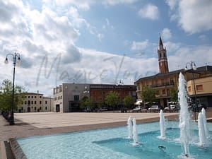
Mortara, nestled in the Lombardy region, presents a unique blend of rich history and local culture appealing to expats and retirees. This charming town, strategically situated in the province of Pavia, is known for its historical significance, most notably the battle between Charlemagne and the Lombards. Rich in agricultural tradition, Mortara is particularly famed for its rice production and delectable local specialties, such as goose salami. Expats can immerse themselves in vibrant cultural events, including the lively goose salami festival held annually in September, featuring historical parades and community games reflecting the town’s heritage.
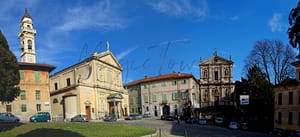
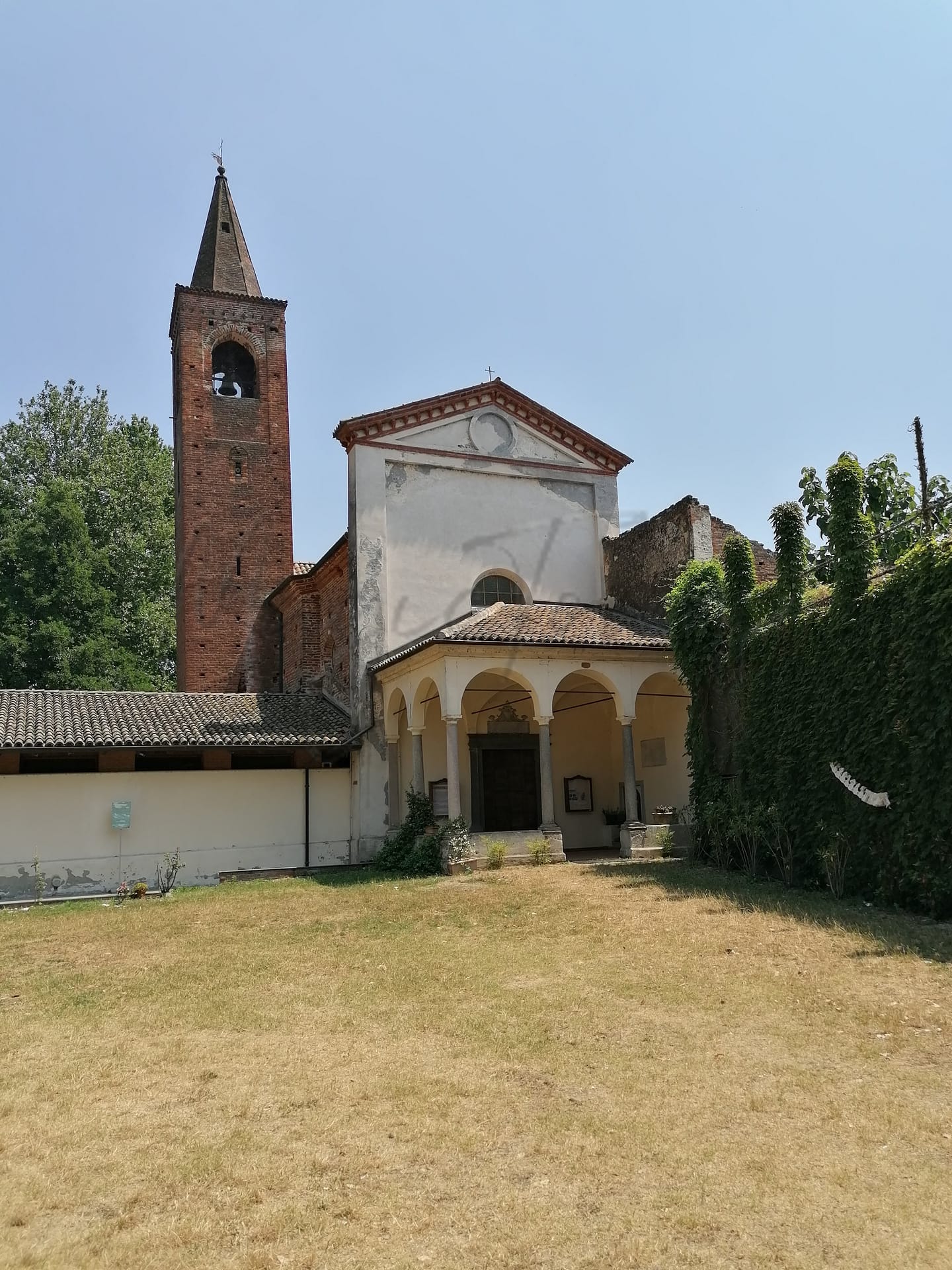
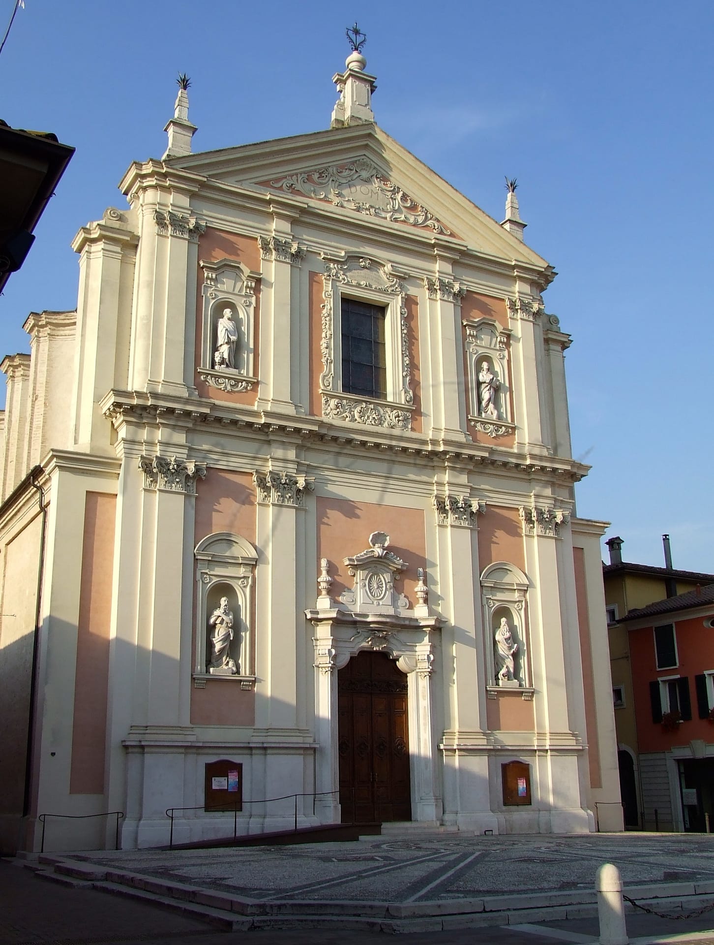
Moreover, Mortara boasts several historical landmarks, including the Gothic basilica of San Lorenzo and the Church of Sant’Albino, renowned for their architectural beauty. While the town delivers a tranquil lifestyle, it may lack the cosmopolitan amenities found in larger cities, yet it offers a comfortable environment with a strong sense of community.
✅ Pros
– High-quality healthcare services available in the region.
– Efficient public transportation connecting to major cities.
– Low unemployment rate ensures economic stability.
– Pleasant climate with moderate temperatures year-round.
– Rich cultural and historical heritage to explore.
– Opportunities for community integration and engagement.
– Good internet connectivity for remote work and leisure.
– Peaceful, non-touristic environment ideal for relaxation.
– Adequate infrastructure supporting daily living needs.
– Scenic landscapes and proximity to nature for outdoor activities.
❌ Cons
– Limited nightlife options may leave you craving more excitement.
– Language barrier can be challenging for non-Italian speakers.
– Less diverse culinary scene for adventurous foodies.
– Occasional air quality issues could affect sensitive individuals.
– Limited shopping options may frustrate retail enthusiasts.
– Smaller town means fewer cultural events and activities.
– Community size might feel isolating for some newcomers.
– Weather can be too humid during summer months.
– Limited job opportunities in specialized fields may deter expats.
– Not many English-speaking services available for expats.
Related Posts
No posts found for the town.
More questions about Mortara ? Ask Magic AI.
Our innovative AI assistant is eager to help. Try it out here: