
Elevation
[?]
Elevation of a city refers to the height above sea level at which the city is located, measured in meters.
1
Population
[?]
This is a town's official population, measured each year by the national statistics authority.
11200
Real Population (5km)
[?]
Our "Real Population" metric reflects more accurately a town's real size by including inhabitants in the immediate vicinity of the town's official borders.
27100
Air Quality Rating
[?]
Based on PM10, PM2.5, NO2, SO2, and ozone levels. Higher scores indicate cleaner air.
90
Region
Puglia
Walkability
Very Walkable
Housing availability
[?]
Based on total number of properties (sale and rent) classifies housing availability into five categories: low, relativel ylow, medium, relatively high and high.
Medium
Avg Download Speed (Mbps) / Avg Upload Speed (Mbps)
72
/ 18
Climate Description
Sunny, warm summers; mild winters; minimal rain; ideal for leisure and outdoor activities.
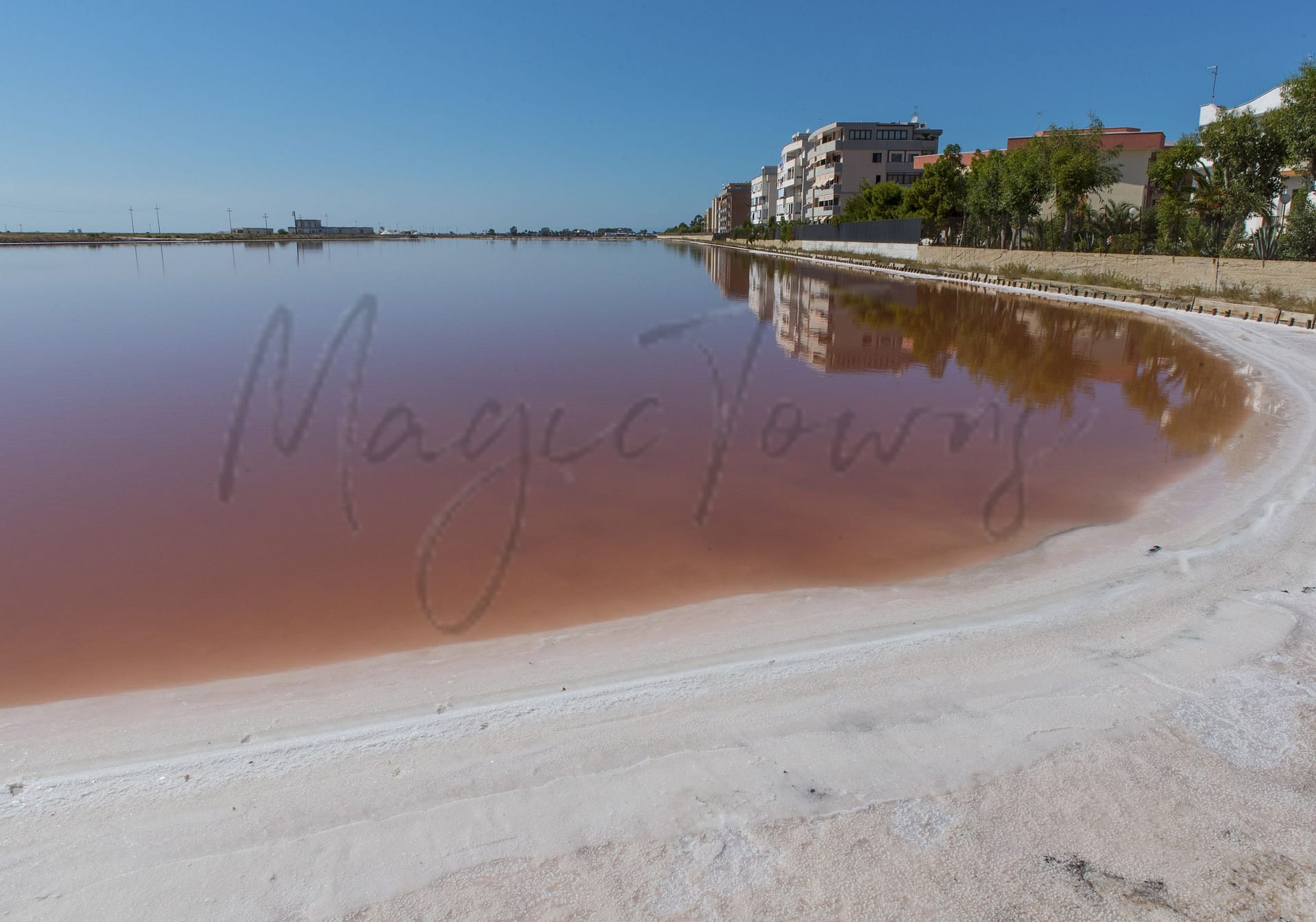
Margherita di Savoia
Puglia
Coastal town with Europe’s largest salt flats, pink waters, vibrant fishing industry, and scenic beaches.
Quality of Life Score
[?]Factors in air quality, amenities, walkability, population, and environmental risks. Higher scores suggest better living conditions.
76
Quality of Infrastructure
[?]Measures internet speed, healthcare access, airports, rail, and walkability. Higher scores mean better connectivity and essential services.
61
Quality of Economy
[?]Based on income, property prices, job availability, and population density. Higher scores indicate stronger economic conditions.
68
Margherita di Savoia Demographics
Population
[?]
This is a town's official population, measured each year by the national statistics authority.
11200
Real Population (5km band)
[?]
Our "Real Population" metric reflects more accurately a town's real size by including inhabitants in the immediate vicinity of the town's official borders.
27100
Births Per 100 Deaths
50.0
Population Data Source
ISTAT,2023
Estimated Unemployment Rate
Touristy Index
[?]
Calculation of tourist density index for the city, comparing its total tourist number to the overall average tourist number of the region
relative to its own population.The index indicates how a location’s tourist density compares to the average, with values above
100 representing higher-than-average density and values below 100 representing lower-than-average density.
Not Touristic
Income per capita (2023)
[?]
This is an estimation of average income per resident for this town, based on 2023 data from the Italian Ministry of Finance.
17000
Income rank in Italy (2023)
[?]
This is a ranking of the town's average income per resident, against the full list of townships in Italy.
5988 out of 7901
Infrastructure and Connectivity
Create an account to explore more
This content is for Members only | Already a Member? Sign in
Infrastructure & Amenities
Create an account to explore more
This content is for Members only | Already a Member? Sign in
Healthcare
Create an account to explore more
This content is for Members only | Already a Member? Sign in
Housing & Property Market
Create an account to explore more
This content is for Members only | Already a Member? Sign in
Connectivity & Digital Access
Create an account to explore more
This content is for Members only | Already a Member? Sign in
Education
Create an account to explore more
This content is for Members only | Already a Member? Sign in
Climate & Weather
Create an account to explore more
This content is for Members only | Already a Member? Sign in
Precipitation
[?] Based on daily climate data for precipitation from OPEN-METEO this parameter indicates how a city's annual precipitation compares to others in terms of percentage, with values ranging from 0 (lowest) to 1 (highest). For example, a percentile rank of 0.75 means the city's total precipitation is higher than 75% of other cities.
Very Low (Bottom 10%)
Sunshine
Exceptional (Top 10%)
Snowfall
Low (11th-20th percentile)
Min Annual Temperature (°C)
[?] This parameter represents the monthly average of daily minimum temperatures for January, based on data from OPEN-METEO.
5.8
Max Annual Temperature (°C)
[?] This parameter represents the monthly average of daily minimum temperatures for January, based on data from OPEN-METEO.
30.6
Climate Description
Margherita di Savoia enjoys consistently sunny skies, making it an appealing locale for those who prefer clear, open days. The summers are generously warm, but rarely oppressive; while winters remain mild with very occasional, light snowfall. Each year, the weather moderates such that while some rain is expected, it hardly disrupts daily life, allowing for planning and outdoor activities. This blend of warmth and minimal wet weather is ideal for retirees and expats seeking a stable climate conducive to leisure and ease. Overall, Margherita di Savoia promises a comfortable climate balance, catering well to residents favouring long, sunlit hours over cloudy conditions.
Annual Temperature Chart (Min)
Error
There was a problem with your SQL connection - Please contact the administrator
There was a problem with your SQL connection - Please contact the administrator
Annual Temperature Chart (Max)
Error
There was a problem with your SQL connection - Please contact the administrator
There was a problem with your SQL connection - Please contact the administrator
Sunny Days By Month
Error
There was a problem with your SQL connection - Please contact the administrator
There was a problem with your SQL connection - Please contact the administrator
Environmental & Air Quality
Create an account to explore more
This content is for Members only | Already a Member? Sign in
Classifications
PM10
[?]
PM10 levels indicate Good air quality at 0–20 µg/m³, Fair at 20–40 µg/m³, Moderate at 40–50 µg/m³, Poor at 50–100 µg/m³, Very Poor at 100–150 µg/m³, and Extremely Poor at 150–1200 µg/m³.
Good
PM2.5
[?]
PM2.5 is Good if PM2.5 levels are between 0–10 µg/m³, Fair between 10–20 µg/m³, Moderate between 20–25 µg/m³, Poor between 25–50 µg/m³, Very Poor between 50–75 µg/m³, and Extremely Poor between 75–800 µg/m³.
Good
NO2
[?]
NO₂ levels are considered Good at 0–40 µg/m³, Fair at 40–90 µg/m³, Moderate at 90–120 µg/m³, Poor at 120–230 µg/m³, Very Poor at 230–340 µg/m³, and Extremely Poor at 340–1000 µg/m³.
Good
SO2
[?]
SO₂ levels indicate Good air quality at 0–100 µg/m³, Fair at 100–200 µg/m³, Moderate at 200–350 µg/m³, Poor at 350–500 µg/m³, Very Poor at 500–750 µg/m³, and Extremely Poor at 750–1250 µg/m³.
Good
O₃
[?]
For O₃, the air is Good at 0–50 µg/m³, Fair at 50–100 µg/m³, Moderate at 100–130 µg/m³, Poor at 130–240 µg/m³, Very Poor at 240–380 µg/m³, and Extremely Poor at 380–800 µg/m³.
Fair
Air Quality Rating
[?]
Based on PM10, PM2.5, NO2, SO2, and ozone levels. Higher scores indicate cleaner air.
90
Air Quality Description
In Margherita di Savoia, a tranquil township in Italy, the air quality predominantly falls into the ‘Good’ range for key particulates and gases. Residents and visitors enjoy relatively clear skies with minimal disturbance from pollution, a factor that enhances the town’s appeal to expats and retirees seeking a healthier, serene lifestyle. However, it is worth noting that ozone levels occasionally shift to ‘Fair’ status, suggesting some variability in air purity. This should be considered by those particularly sensitive to ozone but generally does not detract significantly from the town’s overall pleasant environmental conditions.
In Margherita di Savoia, a tranquil township in Italy, the air quality predominantly falls into the ‘Good’ range for key particulates and gases. Residents and visitors enjoy relatively clear skies with minimal disturbance from pollution, a factor that enhances the town’s appeal to expats and retirees seeking a healthier, serene lifestyle. However, it is worth noting that ozone levels occasionally shift to ‘Fair’ status, suggesting some variability in air purity. This should be considered by those particularly sensitive to ozone but generally does not detract significantly from the town’s overall pleasant environmental conditions.
Town Descriptions
Create an account to explore more
This content is for Members only | Already a Member? Sign in
Getting There
Margherita di Savoia is accessible via the SS16 coastal road, linking it to larger towns and transport hubs. The nearest airport is Bari’s Karol Wojtyla, while Brindisi’s Papola Casale serves as a secondary option. Regional train stations enhance connectivity, though overall infrastructure is rated moderately.
Getting Around
Local Cuisine
Margherita di Savoia, situated in the Puglia region of Italy, boasts a dynamic culinary scene characterized by its rich local traditions and diverse dining options. The town is particularly noted for its seafood, enhanced by the cultivation of the Margherita di Savoia red onion, a Slow Food Presidia ingredient, prominently featured in dishes like octopus, fish soup, and clam soup. The region’s culinary heritage is complemented by the local production of Cerignola olives, often included in appetizers. Dining experiences range from traditional Italian eateries to contemporary bars, reflecting both local culinary practices and international influences, although no Michelin-starred restaurants are currently listed in the town.
Shopping Overview
Shopping in the area encompasses various formats including supermarkets, local boutiques, and small specialty shops that cater to diverse consumer needs. Supermarkets are prevalent, facilitating grocery shopping, while boutiques offer apparel and artisanal products. There are no large-scale shopping malls; however, small shopping centres can be found, providing a compact mix of retail options. Street markets contribute to a vibrant shopping culture, offering fresh produce and local goods, enhancing the shopping experience for residents and visitors alike.
Neighborhoods
Green Areas and Parks
Margherita di Savoia boasts the extensive Saline di Margherita di Savoia nature reserve, a birdwatcher’s paradise with expansive wetlands. The salt pans provide unique landscapes for hiking, such as the Trinitapoli loop, covering approximately 12.6 miles. Other nearby trails include the intermediate Sankt Patrick and Barletta loops, totaling 11.4 miles. These routes offer varying levels of difficulty, accommodating different preferences in outdoor activities. Additionally, the region’s flat terrain over the salt flats and nearby areas provides a scenic yet safe environment for leisurely walks or cycling excursions.
✅ Pros
– Quality healthcare services available for residents and expats.
– Pleasant Mediterranean climate with warm summers and mild winters.
– Rich cultural and historical heritage to explore and enjoy.
– Strong sense of community and integration opportunities for newcomers.
– Clean air with a high air quality rating for residents.
– Less crowded, offering a peaceful living environment away from tourism.
– Accessible transportation options for convenient regional travel.
– Affordable cost of living compared to larger Italian cities.
– Local markets provide fresh produce and support local economy.
– Good internet connectivity for remote work and communication.
❌ Cons
– Limited variety in dining and entertainment options available.
– Public transportation may lack efficiency during off-peak hours.
– Smaller healthcare facilities can lead to longer wait times.
– Job opportunities may be less diverse and limited.
– Limited access to specialized educational facilities for children.
– Infrastructure improvements needed for enhanced living experience.
– Seasonal weather can lead to long, hot summers.
– Internet speeds may not meet high-demand usage needs.
– Local economy heavily reliant on agriculture and tourism.
– Some expats might struggle with language barriers initially.
FAQs
Summary
Margherita di Savoia, located in the heart of Puglia along the Adriatic coast, is known for its striking natural landscapes and cultural heritage. Home to Europe’s largest salt flats, the town boasts unique pink-hued waters, attracting both tourists and migrating flamingos. The local fishing industry remains vibrant, with opportunities for artisanal experiences and fresh seafood dining. The picturesque beaches offer excellent water quality and various lido services, creating a relaxed atmosphere for sun-seekers.
While Margherita di Savoia enjoys a laid-back charm, it is relatively less commercialized than neighboring locales, which may be appealing to some expats and retirees seeking tranquility. However, its location, approximately 46 minutes from the nearest airport, may be a drawback for those preferring immediate urban amenities. Nearby attractions, such as the historic city of Barletta and the UNESCO-listed Castel del Monte, enrich the region’s appeal, showcasing the rich history and culture of this lesser-known gem.
✅ Pros
– Quality healthcare services available for residents and expats.
– Pleasant Mediterranean climate with warm summers and mild winters.
– Rich cultural and historical heritage to explore and enjoy.
– Strong sense of community and integration opportunities for newcomers.
– Clean air with a high air quality rating for residents.
– Less crowded, offering a peaceful living environment away from tourism.
– Accessible transportation options for convenient regional travel.
– Affordable cost of living compared to larger Italian cities.
– Local markets provide fresh produce and support local economy.
– Good internet connectivity for remote work and communication.
❌ Cons
– Limited variety in dining and entertainment options available.
– Public transportation may lack efficiency during off-peak hours.
– Smaller healthcare facilities can lead to longer wait times.
– Job opportunities may be less diverse and limited.
– Limited access to specialized educational facilities for children.
– Infrastructure improvements needed for enhanced living experience.
– Seasonal weather can lead to long, hot summers.
– Internet speeds may not meet high-demand usage needs.
– Local economy heavily reliant on agriculture and tourism.
– Some expats might struggle with language barriers initially.
Related Posts
More questions about Margherita di Savoia ? Ask Magic AI.
Our innovative AI assistant is eager to help. Try it out here: