
Elevation
[?]
Elevation of a city refers to the height above sea level at which the city is located, measured in meters.
473
Population
[?]
This is a town's official population, measured each year by the national statistics authority.
20700
Real Population (5km)
[?]
Our "Real Population" metric reflects more accurately a town's real size by including inhabitants in the immediate vicinity of the town's official borders.
35300
Air Quality Rating
[?]
Based on PM10, PM2.5, NO2, SO2, and ozone levels. Higher scores indicate cleaner air.
84
Region
Molise
Walkability
Walker’s Paradise
Housing availability
[?]
Based on total number of properties (sale and rent) classifies housing availability into five categories: low, relativel ylow, medium, relatively high and high.
High
Avg Download Speed (Mbps) / Avg Upload Speed (Mbps)
148
/ 80
Climate Description
Temperate climate with mild winters, warm summers, and ample sunshine year-round.
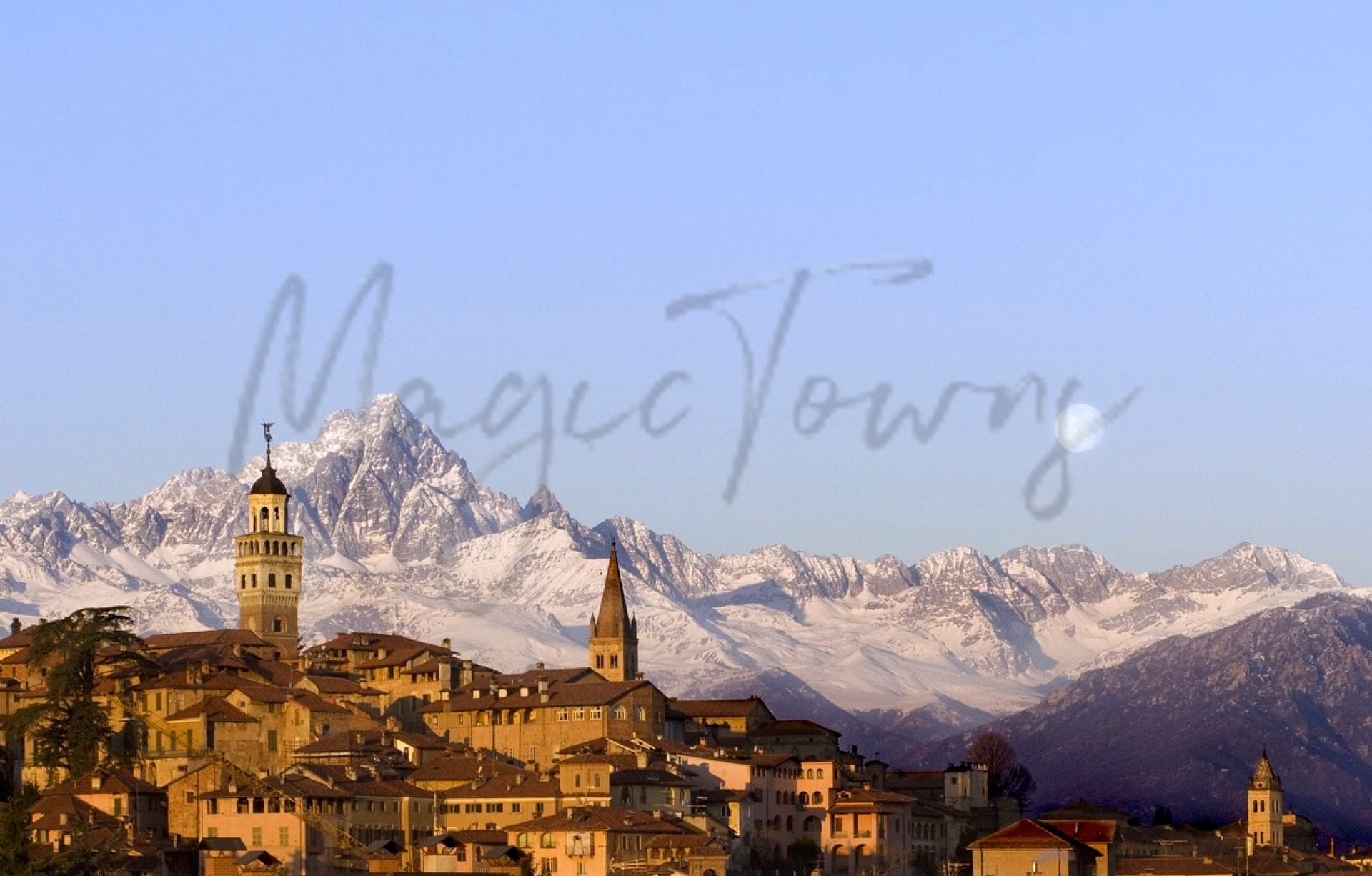
Isernia
Molise
Historic town with a cultural community, notable for agriculture, medieval architecture, and walkability.
Quality of Life Score
[?]Factors in air quality, amenities, walkability, population, and environmental risks. Higher scores suggest better living conditions.
69
Quality of Infrastructure
[?]Measures internet speed, healthcare access, airports, rail, and walkability. Higher scores mean better connectivity and essential services.
66
Quality of Economy
[?]Based on income, property prices, job availability, and population density. Higher scores indicate stronger economic conditions.
78
Isernia Demographics
Population
[?]
This is a town's official population, measured each year by the national statistics authority.
20700
Real Population (5km band)
[?]
Our "Real Population" metric reflects more accurately a town's real size by including inhabitants in the immediate vicinity of the town's official borders.
35300
Births Per 100 Deaths
50.0
Population Data Source
ISTAT,2023
Estimated Unemployment Rate
Touristy Index
[?]
Calculation of tourist density index for the city, comparing its total tourist number to the overall average tourist number of the region
relative to its own population.The index indicates how a location’s tourist density compares to the average, with values above
100 representing higher-than-average density and values below 100 representing lower-than-average density.
Not Touristic
Income per capita (2023)
[?]
This is an estimation of average income per resident for this town, based on 2023 data from the Italian Ministry of Finance.
21100
Income rank in Italy (2023)
[?]
This is a ranking of the town's average income per resident, against the full list of townships in Italy.
3411 out of 7901
Infrastructure and Connectivity
Create an account to explore more
This content is for Members only | Already a Member? Sign in
Infrastructure & Amenities
Create an account to explore more
This content is for Members only | Already a Member? Sign in
Healthcare
Create an account to explore more
This content is for Members only | Already a Member? Sign in
Housing & Property Market
Create an account to explore more
This content is for Members only | Already a Member? Sign in
Connectivity & Digital Access
Create an account to explore more
This content is for Members only | Already a Member? Sign in
Education
Create an account to explore more
This content is for Members only | Already a Member? Sign in
Climate & Weather
Create an account to explore more
This content is for Members only | Already a Member? Sign in
Precipitation
[?] Based on daily climate data for precipitation from OPEN-METEO this parameter indicates how a city's annual precipitation compares to others in terms of percentage, with values ranging from 0 (lowest) to 1 (highest). For example, a percentile rank of 0.75 means the city's total precipitation is higher than 75% of other cities.
Somewhat High (61st-70th percentile)
Sunshine
Average (41st-50th percentile)
Snowfall
Average (41st-50th percentile)
Min Annual Temperature (°C)
[?] This parameter represents the monthly average of daily minimum temperatures for January, based on data from OPEN-METEO.
0.2
Max Annual Temperature (°C)
[?] This parameter represents the monthly average of daily minimum temperatures for January, based on data from OPEN-METEO.
29.2
Climate Description
Isernia, Italy, boasts a temperate climate that aligns well with the needs of expats and retirees seeking a stable, comfortable environment. The town enjoys ample sunshine through most of the year, ensuring vibrant outdoor activities and a robust growth of local flora. Winters are mild with occasional snowfall, lending a picturesque quality to the landscape without causing significant inconvenience. Summers are warm but not excessively so, making Isernia an ideal retreat from more extreme temperatures experienced elsewhere. This combination of pleasant conditions supports an active and engaging lifestyle for its residents and visitors alike.
Annual Temperature Chart (Min)
Error
There was a problem with your SQL connection - Please contact the administrator
There was a problem with your SQL connection - Please contact the administrator
Annual Temperature Chart (Max)
Error
There was a problem with your SQL connection - Please contact the administrator
There was a problem with your SQL connection - Please contact the administrator
Sunny Days By Month
Error
There was a problem with your SQL connection - Please contact the administrator
There was a problem with your SQL connection - Please contact the administrator
Environmental & Air Quality
Create an account to explore more
This content is for Members only | Already a Member? Sign in
Classifications
PM10
[?]
PM10 levels indicate Good air quality at 0–20 µg/m³, Fair at 20–40 µg/m³, Moderate at 40–50 µg/m³, Poor at 50–100 µg/m³, Very Poor at 100–150 µg/m³, and Extremely Poor at 150–1200 µg/m³.
Good
PM2.5
[?]
PM2.5 is Good if PM2.5 levels are between 0–10 µg/m³, Fair between 10–20 µg/m³, Moderate between 20–25 µg/m³, Poor between 25–50 µg/m³, Very Poor between 50–75 µg/m³, and Extremely Poor between 75–800 µg/m³.
Good
NO2
[?]
NO₂ levels are considered Good at 0–40 µg/m³, Fair at 40–90 µg/m³, Moderate at 90–120 µg/m³, Poor at 120–230 µg/m³, Very Poor at 230–340 µg/m³, and Extremely Poor at 340–1000 µg/m³.
Good
SO2
[?]
SO₂ levels indicate Good air quality at 0–100 µg/m³, Fair at 100–200 µg/m³, Moderate at 200–350 µg/m³, Poor at 350–500 µg/m³, Very Poor at 500–750 µg/m³, and Extremely Poor at 750–1250 µg/m³.
Good
O₃
[?]
For O₃, the air is Good at 0–50 µg/m³, Fair at 50–100 µg/m³, Moderate at 100–130 µg/m³, Poor at 130–240 µg/m³, Very Poor at 240–380 µg/m³, and Extremely Poor at 380–800 µg/m³.
Fair
Air Quality Rating
[?]
Based on PM10, PM2.5, NO2, SO2, and ozone levels. Higher scores indicate cleaner air.
84
Air Quality Description
Isernia, positioned within Italy’s versatile landscapes, presents an attractive option for clean living, reflected through measured air quality indices. With particulate matter and gas concentrations routinely falling into ‘Good’ categories, residents enjoy an environment substantially free from the urban pollution common in denser metropolises. While most pollutants here comply with recommended wellness standards, local ozone levels occasionally tip into ‘Fair’ territory, denoting slightly elevated but typically non-hazardous conditions. This ensures Isernia as a sound selection for retirees and expats prioritizing healthful living environments in their relocation considerations.
Isernia, positioned within Italy’s versatile landscapes, presents an attractive option for clean living, reflected through measured air quality indices. With particulate matter and gas concentrations routinely falling into ‘Good’ categories, residents enjoy an environment substantially free from the urban pollution common in denser metropolises. While most pollutants here comply with recommended wellness standards, local ozone levels occasionally tip into ‘Fair’ territory, denoting slightly elevated but typically non-hazardous conditions. This ensures Isernia as a sound selection for retirees and expats prioritizing healthful living environments in their relocation considerations.
Town Descriptions
Create an account to explore more
This content is for Members only | Already a Member? Sign in
Getting There
Isernia is accessible via SS85 and A1 highways, linking it to major urban centers. The nearest airports are Naples and Rome, while local train services, although limited, connect to nearby towns, contributing to moderate connectivity. Infrastructure quality is rated at 66 out of 100.
Getting Around
Local Cuisine
Isernia, nestled in the Molise region, boasts a culinary scene deeply rooted in traditional Italian flavors, with dishes emphasizing local produce and rustic ingredients. The region is known for specialties such as Cavatelli, a type of pasta often served with rich sauces like lamb ragù or wild mushrooms. Other notable dishes include Brodetto alla Termolese, a fish stew, and Ventricina, a cured meat. The gastronomy here reflects the ‘cucina povera’ philosophy, prioritizing simple, hearty ingredients. The dining landscape in Isernia is a blend of traditional eateries that offer regional cuisine and a few international options, although Italian fare dominates the scene. While detailed rankings are scarce, there are mentions of establishments within the region that are recognized for their quality, however, as of now there are no Michelin-starred restaurants specifically located in Isernia. Overall, Isernia’s culinary offerings showcase the rich heritage of Molise while offering diverse dining experiences that cater to both locals and visitors alike.
Shopping Overview
The area features several shopping options catering to a range of needs. Two main shopping malls provide a variety of retail experiences, while numerous specialty and gift shops offer unique local products. Supermarkets are also accessible for everyday grocery needs. The mix of venues includes both modern centres and local markets, appealing to diverse consumer preferences. Such an environment facilitates a comfortable shopping experience for expats and retirees, enhancing their quality of life in the region.
Neighborhoods
Green Areas and Parks
Isernia, located in Molise, Italy, offers numerous outdoor activities suitable for expats and retirees. The region includes several prominent hiking trails, such as the Isernia – Miranda – Monte Cimorre – Pesche trail, spanning 24.5 miles with significant elevation changes. Other options include the challenging Sentiero Italia, Q10: Isernia – Pescolanciano trail and the moderate Le Piane d’Isernia path. Additionally, natural attractions such as the Staffoli Horses equestrian trails and the Villa Comunale provide diverse outdoor experiences.
✅ Pros
– Rich cultural and historical backdrop enhances daily life experience.
– Strong community spirit promotes integration and social connections.
– Beautiful natural surroundings provide peace and tranquility.
– Good air quality supports a healthier lifestyle.
– Affordable cost of living compared to other Italian towns.
– Reliable public transportation connects to surrounding regions.
– Healthcare facilities available, ensuring basic medical needs are met.
– Quiet atmosphere ideal for retirees seeking a relaxed lifestyle.
– Local markets offer fresh produce and artisanal goods.
– Diverse outdoor activities available for nature enthusiasts.
❌ Cons
– Healthcare quality may not meet all expats’ expectations.
– Limited educational facilities for families with children.
– Internet speed can be frustratingly slow at times.
– Unemployment rates fluctuate, impacting local economic stability.
– Infrastructure may feel lacking in certain modern amenities.
– Limited tourist presence can mean fewer social activities.
– Weather can be quite variable, especially in winter months.
– Local bureaucracy might test your patience and language skills.
– Cultural events are fewer than in larger Italian towns.
– Rural lifestyle may feel isolating for some newcomers.
FAQs
Summary
Isernia, located in the picturesque Molise region, offers a blend of historical depth and modern conveniences that could appeal to expats and retirees. Rich in culture, this town boasts attractions such as the Museo Nazionale del Paleolitico, which showcases ancient artifacts, and the vibrant Centro Storico, where medieval architecture meets contemporary life. The robust local community organizes cultural events, ensuring newcomers feel welcomed and engaged. Notable industries revolve around agriculture, particularly fine wines and local delicacies.
However, expats might encounter challenges; Isernia’s remote location means accessing larger urban amenities can require patience, with the nearest major airport over an hour away. The healthcare ranking is moderate, which could be a concern for some. Despite these drawbacks, the town features a high walkability score and pleasant air quality, offering a serene lifestyle amidst Italy’s enchanting landscapes.
✅ Pros
– Rich cultural and historical backdrop enhances daily life experience.
– Strong community spirit promotes integration and social connections.
– Beautiful natural surroundings provide peace and tranquility.
– Good air quality supports a healthier lifestyle.
– Affordable cost of living compared to other Italian towns.
– Reliable public transportation connects to surrounding regions.
– Healthcare facilities available, ensuring basic medical needs are met.
– Quiet atmosphere ideal for retirees seeking a relaxed lifestyle.
– Local markets offer fresh produce and artisanal goods.
– Diverse outdoor activities available for nature enthusiasts.
❌ Cons
– Healthcare quality may not meet all expats’ expectations.
– Limited educational facilities for families with children.
– Internet speed can be frustratingly slow at times.
– Unemployment rates fluctuate, impacting local economic stability.
– Infrastructure may feel lacking in certain modern amenities.
– Limited tourist presence can mean fewer social activities.
– Weather can be quite variable, especially in winter months.
– Local bureaucracy might test your patience and language skills.
– Cultural events are fewer than in larger Italian towns.
– Rural lifestyle may feel isolating for some newcomers.
Related Posts
No posts found for the town.
More questions about Isernia ? Ask Magic AI.
Our innovative AI assistant is eager to help. Try it out here: