Elevation
[?]
Elevation of a city refers to the height above sea level at which the city is located, measured in meters.
70
Population
[?]
This is a town's official population, measured each year by the national statistics authority.
25500
Real Population (5km)
[?]
Our "Real Population" metric reflects more accurately a town's real size by including inhabitants in the immediate vicinity of the town's official borders.
149200
Air Quality Rating
[?]
Based on PM10, PM2.5, NO2, SO2, and ozone levels. Higher scores indicate cleaner air.
86
Region
Puglia
Walkability
Walker’s Paradise
Housing availability
[?]
Based on total number of properties (sale and rent) classifies housing availability into five categories: low, relativel ylow, medium, relatively high and high.
Relatively Low
Avg Download Speed (Mbps) / Avg Upload Speed (Mbps)
111
/ 44
Climate Description
Mild climate with warm summers, gentle winters, ample sunshine, rare snow, and occasional rain.
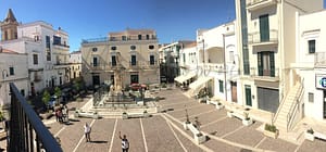
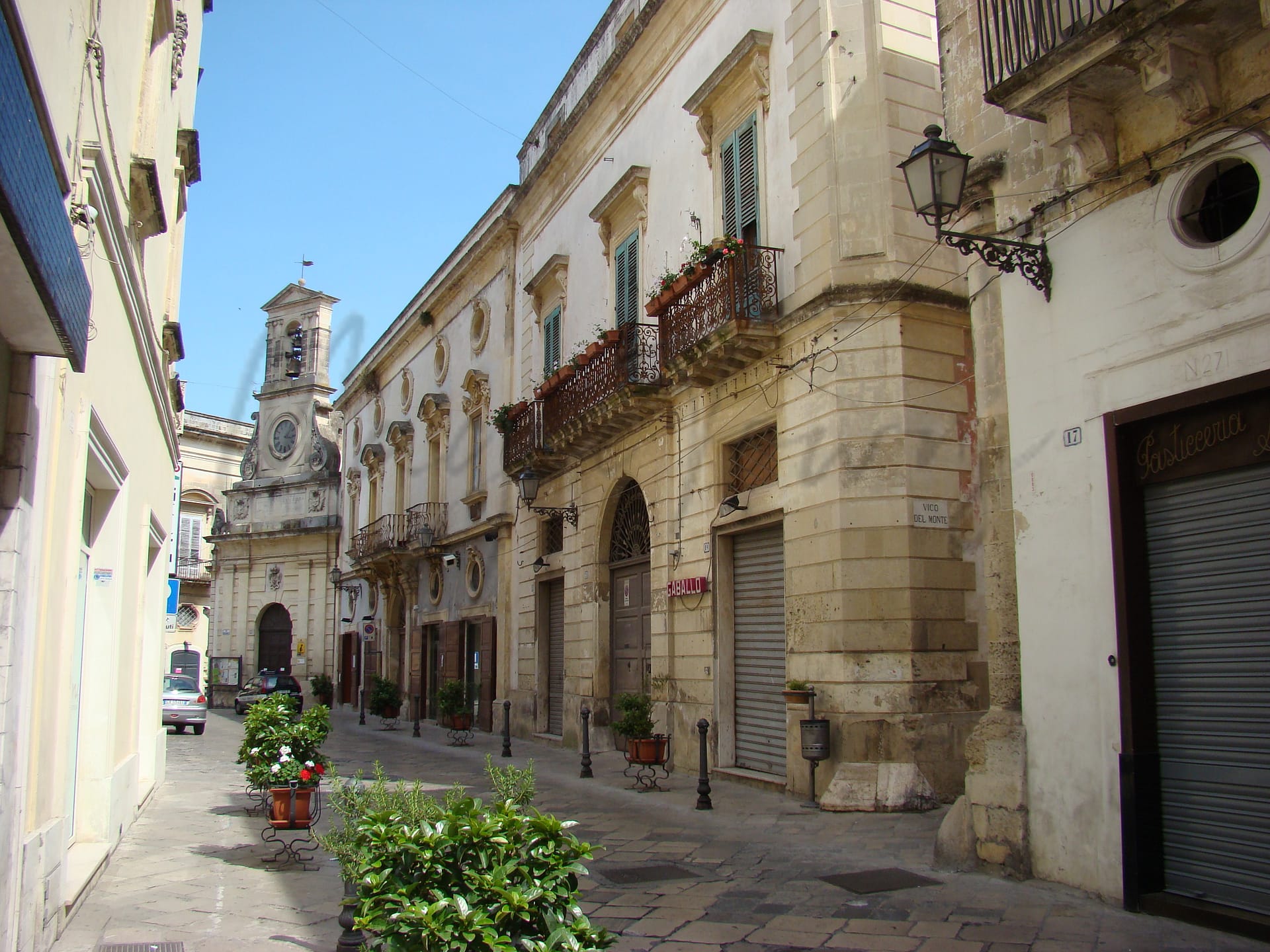
Galatina
Puglia
Historic town in Puglia known for architecture, culture, agriculture, cuisine, and walkability.
Quality of Life Score
[?]Factors in air quality, amenities, walkability, population, and environmental risks. Higher scores suggest better living conditions.
83
Quality of Infrastructure
[?]Measures internet speed, healthcare access, airports, rail, and walkability. Higher scores mean better connectivity and essential services.
65
Quality of Economy
[?]Based on income, property prices, job availability, and population density. Higher scores indicate stronger economic conditions.
67
Galatina Demographics
Population
[?]
This is a town's official population, measured each year by the national statistics authority.
25500
Real Population (5km band)
[?]
Our "Real Population" metric reflects more accurately a town's real size by including inhabitants in the immediate vicinity of the town's official borders.
149200
Births Per 100 Deaths
40.0
Population Data Source
ISTAT,2023
Estimated Unemployment Rate
Touristy Index
[?]
Calculation of tourist density index for the city, comparing its total tourist number to the overall average tourist number of the region
relative to its own population.The index indicates how a location’s tourist density compares to the average, with values above
100 representing higher-than-average density and values below 100 representing lower-than-average density.
Not Touristic
Income per capita (2023)
[?]
This is an estimation of average income per resident for this town, based on 2023 data from the Italian Ministry of Finance.
18400
Income rank in Italy (2023)
[?]
This is a ranking of the town's average income per resident, against the full list of townships in Italy.
5159 out of 7901
Infrastructure and Connectivity
Create an account to explore more
This content is for Members only | Already a Member? Sign in
Infrastructure & Amenities
Create an account to explore more
This content is for Members only | Already a Member? Sign in
Healthcare
Create an account to explore more
This content is for Members only | Already a Member? Sign in
Housing & Property Market
Create an account to explore more
This content is for Members only | Already a Member? Sign in
Connectivity & Digital Access
Create an account to explore more
This content is for Members only | Already a Member? Sign in
Education
Create an account to explore more
This content is for Members only | Already a Member? Sign in
Climate & Weather
Create an account to explore more
This content is for Members only | Already a Member? Sign in
Precipitation
[?] Based on daily climate data for precipitation from OPEN-METEO this parameter indicates how a city's annual precipitation compares to others in terms of percentage, with values ranging from 0 (lowest) to 1 (highest). For example, a percentile rank of 0.75 means the city's total precipitation is higher than 75% of other cities.
Low (11th-20th percentile)
Sunshine
Exceptional (Top 10%)
Snowfall
Very Low (Bottom 10%)
Min Annual Temperature (°C)
[?] This parameter represents the monthly average of daily minimum temperatures for January, based on data from OPEN-METEO.
6.9
Max Annual Temperature (°C)
[?] This parameter represents the monthly average of daily minimum temperatures for January, based on data from OPEN-METEO.
31.9
Climate Description
Galatina benefits from a predominantly mild climate characterized by warm summers and gentle winters, fitting for those seeking a comfortable, stable environment. The town enjoys an ample amount of sunshine throughout the year, ensuring that outdoor activities and leisure are rarely disrupted by gloomy weather. Occasional rainfall sustains the verdant landscapes without overwhelming residents, making Galatina an attractive location for expatriates and retirees inclined towards nurturing a tranquil lifestyle amidst picturesque settings. Snowfall here is an extreme rarity, adding just a touch of seasonal charm without the inconvenience typically associated with colder climates. This balance makes Galatina an ideal choice for anyone seeking a serene retreat with plenty of sunny days.
Annual Temperature Chart (Min)
Error
There was a problem with your SQL connection - Please contact the administrator
There was a problem with your SQL connection - Please contact the administrator
Annual Temperature Chart (Max)
Error
There was a problem with your SQL connection - Please contact the administrator
There was a problem with your SQL connection - Please contact the administrator
Sunny Days By Month
Error
There was a problem with your SQL connection - Please contact the administrator
There was a problem with your SQL connection - Please contact the administrator
Environmental & Air Quality
Create an account to explore more
This content is for Members only | Already a Member? Sign in
Classifications
PM10
[?]
PM10 levels indicate Good air quality at 0–20 µg/m³, Fair at 20–40 µg/m³, Moderate at 40–50 µg/m³, Poor at 50–100 µg/m³, Very Poor at 100–150 µg/m³, and Extremely Poor at 150–1200 µg/m³.
Good
PM2.5
[?]
PM2.5 is Good if PM2.5 levels are between 0–10 µg/m³, Fair between 10–20 µg/m³, Moderate between 20–25 µg/m³, Poor between 25–50 µg/m³, Very Poor between 50–75 µg/m³, and Extremely Poor between 75–800 µg/m³.
Fair
NO2
[?]
NO₂ levels are considered Good at 0–40 µg/m³, Fair at 40–90 µg/m³, Moderate at 90–120 µg/m³, Poor at 120–230 µg/m³, Very Poor at 230–340 µg/m³, and Extremely Poor at 340–1000 µg/m³.
Good
SO2
[?]
SO₂ levels indicate Good air quality at 0–100 µg/m³, Fair at 100–200 µg/m³, Moderate at 200–350 µg/m³, Poor at 350–500 µg/m³, Very Poor at 500–750 µg/m³, and Extremely Poor at 750–1250 µg/m³.
Good
O₃
[?]
For O₃, the air is Good at 0–50 µg/m³, Fair at 50–100 µg/m³, Moderate at 100–130 µg/m³, Poor at 130–240 µg/m³, Very Poor at 240–380 µg/m³, and Extremely Poor at 380–800 µg/m³.
Fair
Air Quality Rating
[?]
Based on PM10, PM2.5, NO2, SO2, and ozone levels. Higher scores indicate cleaner air.
86
Air Quality Description
Situated in the southern charms of Italy, Galatina offers its residents an inviting atmosphere with generally commendable air quality. The town, designed with narrow cobblestone streets lined with historic architecture, benefits from levels of particulate matter (PM10) that are typically within the good range, ensuring that day-to-day activities can proceed with minimal concern for respiratory disturbances. The slightly higher readings of finer particulate matter (PM2.5) and ozone may warrant attention from those particularly sensitive to air quality. Overall, nitrogen and sulphur dioxide levels remain low, contributing to an environment in which outdoor activities are rarely compromised by air pollution. Galatina provides a satisfactory setting for those prioritizing a life amidst clearer skies.
Situated in the southern charms of Italy, Galatina offers its residents an inviting atmosphere with generally commendable air quality. The town, designed with narrow cobblestone streets lined with historic architecture, benefits from levels of particulate matter (PM10) that are typically within the good range, ensuring that day-to-day activities can proceed with minimal concern for respiratory disturbances. The slightly higher readings of finer particulate matter (PM2.5) and ozone may warrant attention from those particularly sensitive to air quality. Overall, nitrogen and sulphur dioxide levels remain low, contributing to an environment in which outdoor activities are rarely compromised by air pollution. Galatina provides a satisfactory setting for those prioritizing a life amidst clearer skies.
Town Descriptions
Create an account to explore more
This content is for Members only | Already a Member? Sign in
Getting There
Galatina’s connectivity is facilitated by nearby airports at Brindisi and Bari. The town is accessible via the SS16 and SS101 roads. Local train stations offer limited regional connectivity, underscored by moderate scores for overall transport infrastructure.
Getting Around
Local Cuisine
Galatina’s culinary scene is a vibrant blend of traditional Salento cuisine and modern dining options, highlighting local ingredients and historic recipes. The town is particularly renowned for its pasticciotto, a pastry with a creamy filling that serves as a breakfast staple. A variety of local restaurants serve hearty dishes that include homemade pastas and grilled meats, reflecting the rich culinary heritage of Puglia. In recent years, the town has also embraced modern culinary techniques, with some establishments like those awarded the Bib Gourmand distinction creating innovative interpretations of classic dishes. Although Galatina does not currently host any Michelin-starred restaurants, it features Bib Gourmand recipients known for quality dining experiences.
Shopping Overview
The shopping landscape features a range of options, including supermarkets for daily needs, local boutiques for unique fashion items, and open-air markets selling regional produce. Prominent shopping centres offer an array of retail experiences, from international brands to local artisans. Expats can find everything from grocery essentials to specialty goods, ensuring a comprehensive shopping experience tailored to diverse lifestyles.
Neighborhoods
Green Areas and Parks
Galatina in Puglia offers several notable hiking trails, providing opportunities for outdoor activities. Routes such as Galatina – Chiesa di San Vito to Chiesa Madonna della neve, Galatina – Ruffano, and Cammino di Tonino Bello are popular among outdoor enthusiasts. These trails vary in distance, with routes like Galatina – Ruffano extending approximately 20 miles, and others such as Galatina – Chiesa di San Vito covering nearly 17 miles. These options cater to both casual walkers and more dedicated hikers seeking to explore the area’s natural landscapes.
✅ Pros
– Rich cultural and historical backdrop to explore and enjoy.
– Strong community with integration opportunities for newcomers.
– Mild Mediterranean climate with warm summers and mild winters.
– Access to local healthcare facilities with reasonable quality.
– Good air quality, promoting a healthy living environment.
– Less touristy, offering an authentic Italian lifestyle experience.
– Affordable cost of living compared to larger cities.
– Decent infrastructure supporting daily transportation and services.
– A variety of local markets for fresh produce and goods.
– Close proximity to beautiful beaches and stunning countryside.
❌ Cons
– Limited healthcare options may lead to longer wait times.
– Healthcare quality is below average for European standards.
– Public transportation can be infrequent and less reliable.
– Job opportunities are limited, especially for expats.
– Internet speeds may not meet demands of remote work.
– Local shops may lack variety compared to bigger cities.
– Language barrier can complicate daily interactions for newcomers.
– Limited cultural activities may lead to boredom over time.
– Hot summers can be quite uncomfortable without proper cooling.
– Seasonal influx of tourists can disrupt local tranquility.
FAQs
Summary
Galatina, located in the heart of Puglia’s Salento region, is a charming town known for its rich cultural heritage and architectural beauty. It features a well-preserved historical center characterized by a mix of Romanesque and Baroque styles, highlighted by the stunning Church of Saint Catherine. The town hosts a vibrant cultural scene, enhancing its appeal for expats and retirees alike.
Agriculture is a key industry, particularly wine production and tobacco processing. Most notably, Galatina is celebrated for its local cuisine, including pasticciotti from Pasticceria Ascalone, a culinary landmark. While the town’s relatively small size may limit some urban conveniences, its pedestrian-friendly environment boasts a high walkability score, making it easy to explore its charming streets. With healthcare services and good internet connectivity, Galatina offers a balance of living amid historical allure and modern accessibility, all while maintaining close proximity to the stunning Adriatic coastline.
✅ Pros
– Rich cultural and historical backdrop to explore and enjoy.
– Strong community with integration opportunities for newcomers.
– Mild Mediterranean climate with warm summers and mild winters.
– Access to local healthcare facilities with reasonable quality.
– Good air quality, promoting a healthy living environment.
– Less touristy, offering an authentic Italian lifestyle experience.
– Affordable cost of living compared to larger cities.
– Decent infrastructure supporting daily transportation and services.
– A variety of local markets for fresh produce and goods.
– Close proximity to beautiful beaches and stunning countryside.
❌ Cons
– Limited healthcare options may lead to longer wait times.
– Healthcare quality is below average for European standards.
– Public transportation can be infrequent and less reliable.
– Job opportunities are limited, especially for expats.
– Internet speeds may not meet demands of remote work.
– Local shops may lack variety compared to bigger cities.
– Language barrier can complicate daily interactions for newcomers.
– Limited cultural activities may lead to boredom over time.
– Hot summers can be quite uncomfortable without proper cooling.
– Seasonal influx of tourists can disrupt local tranquility.
Related Posts
More questions about Galatina ? Ask Magic AI.
Our innovative AI assistant is eager to help. Try it out here: