
Elevation
[?]
Elevation of a city refers to the height above sea level at which the city is located, measured in meters.
26
Population
[?]
This is a town's official population, measured each year by the national statistics authority.
18500
Real Population (5km)
[?]
Our "Real Population" metric reflects more accurately a town's real size by including inhabitants in the immediate vicinity of the town's official borders.
429100
Air Quality Rating
[?]
Based on PM10, PM2.5, NO2, SO2, and ozone levels. Higher scores indicate cleaner air.
92
Region
Emilia-Romagna
Walkability
Very Walkable
Housing availability
[?]
Based on total number of properties (sale and rent) classifies housing availability into five categories: low, relativel ylow, medium, relatively high and high.
Relatively Low
Avg Download Speed (Mbps) / Avg Upload Speed (Mbps)
285
/ 187
Climate Description
Balanced climate with sunny days, mild snowfall, moderate warmth, and manageable precipitation.
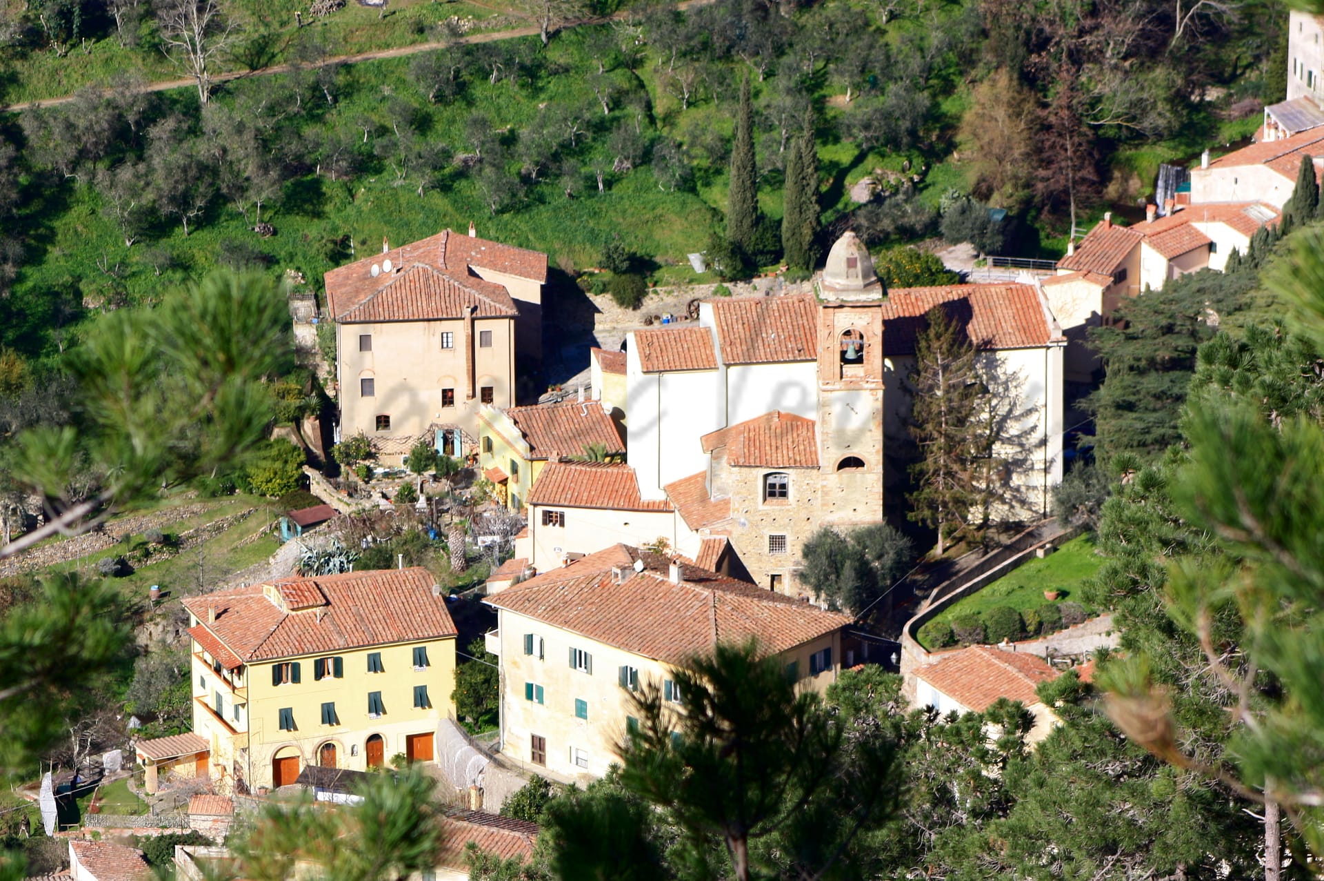
Castel Maggiore
Emilia-Romagna
A town near Bologna known for historical villas, cycling routes, gastronomy, and efficient public transport.
Quality of Life Score
[?]Factors in air quality, amenities, walkability, population, and environmental risks. Higher scores suggest better living conditions.
92
Quality of Infrastructure
[?]Measures internet speed, healthcare access, airports, rail, and walkability. Higher scores mean better connectivity and essential services.
70
Quality of Economy
[?]Based on income, property prices, job availability, and population density. Higher scores indicate stronger economic conditions.
85
Castel Maggiore Demographics
Population
[?]
This is a town's official population, measured each year by the national statistics authority.
18500
Real Population (5km band)
[?]
Our "Real Population" metric reflects more accurately a town's real size by including inhabitants in the immediate vicinity of the town's official borders.
429100
Births Per 100 Deaths
50.0
Population Data Source
ISTAT,2023
Estimated Unemployment Rate
Touristy Index
[?]
Calculation of tourist density index for the city, comparing its total tourist number to the overall average tourist number of the region
relative to its own population.The index indicates how a location’s tourist density compares to the average, with values above
100 representing higher-than-average density and values below 100 representing lower-than-average density.
Some Tourism
Income per capita (2023)
[?]
This is an estimation of average income per resident for this town, based on 2023 data from the Italian Ministry of Finance.
26700
Income rank in Italy (2023)
[?]
This is a ranking of the town's average income per resident, against the full list of townships in Italy.
90 out of 7901
Infrastructure and Connectivity
Create an account to explore more
This content is for Members only | Already a Member? Sign in
Infrastructure & Amenities
Create an account to explore more
This content is for Members only | Already a Member? Sign in
Healthcare
Create an account to explore more
This content is for Members only | Already a Member? Sign in
Housing & Property Market
Create an account to explore more
This content is for Members only | Already a Member? Sign in
Connectivity & Digital Access
Create an account to explore more
This content is for Members only | Already a Member? Sign in
Education
Create an account to explore more
This content is for Members only | Already a Member? Sign in
Climate & Weather
Create an account to explore more
This content is for Members only | Already a Member? Sign in
Precipitation
[?] Based on daily climate data for precipitation from OPEN-METEO this parameter indicates how a city's annual precipitation compares to others in terms of percentage, with values ranging from 0 (lowest) to 1 (highest). For example, a percentile rank of 0.75 means the city's total precipitation is higher than 75% of other cities.
Low (11th-20th percentile)
Sunshine
Somewhat High (61st-70th percentile)
Snowfall
Average (41st-50th percentile)
Min Annual Temperature (°C)
[?] This parameter represents the monthly average of daily minimum temperatures for January, based on data from OPEN-METEO.
0.2
Max Annual Temperature (°C)
[?] This parameter represents the monthly average of daily minimum temperatures for January, based on data from OPEN-METEO.
31.8
Climate Description
In Castel Maggiore, the climate offers a balanced experience of warmth and briskness through different seasons. The town enjoys generous sunny days, ensuring an abundant luminescence throughout the year. Winter is marked by mild snowfall, lightly dusting the landscape, while summers peak with significant warmth, though not excessively so. The moderate precipitation levels ensure lush greenery without overwhelming residents and visitors with dampness. Year-round, temperatures are moderated, and neither extreme cold nor heat is frequent, crafting an ideal climate for those seeking a comfortable and steady weather pattern. This balanced environment appeals especially to those engaged in outdoor activities, retirees, or expats looking for a serene climate.
Annual Temperature Chart (Min)
Error
There was a problem with your SQL connection - Please contact the administrator
There was a problem with your SQL connection - Please contact the administrator
Annual Temperature Chart (Max)
Error
There was a problem with your SQL connection - Please contact the administrator
There was a problem with your SQL connection - Please contact the administrator
Sunny Days By Month
Error
There was a problem with your SQL connection - Please contact the administrator
There was a problem with your SQL connection - Please contact the administrator
Environmental & Air Quality
Create an account to explore more
This content is for Members only | Already a Member? Sign in
Classifications
PM10
[?]
PM10 levels indicate Good air quality at 0–20 µg/m³, Fair at 20–40 µg/m³, Moderate at 40–50 µg/m³, Poor at 50–100 µg/m³, Very Poor at 100–150 µg/m³, and Extremely Poor at 150–1200 µg/m³.
Fair
PM2.5
[?]
PM2.5 is Good if PM2.5 levels are between 0–10 µg/m³, Fair between 10–20 µg/m³, Moderate between 20–25 µg/m³, Poor between 25–50 µg/m³, Very Poor between 50–75 µg/m³, and Extremely Poor between 75–800 µg/m³.
Fair
NO2
[?]
NO₂ levels are considered Good at 0–40 µg/m³, Fair at 40–90 µg/m³, Moderate at 90–120 µg/m³, Poor at 120–230 µg/m³, Very Poor at 230–340 µg/m³, and Extremely Poor at 340–1000 µg/m³.
Good
SO2
[?]
SO₂ levels indicate Good air quality at 0–100 µg/m³, Fair at 100–200 µg/m³, Moderate at 200–350 µg/m³, Poor at 350–500 µg/m³, Very Poor at 500–750 µg/m³, and Extremely Poor at 750–1250 µg/m³.
Good
O₃
[?]
For O₃, the air is Good at 0–50 µg/m³, Fair at 50–100 µg/m³, Moderate at 100–130 µg/m³, Poor at 130–240 µg/m³, Very Poor at 240–380 µg/m³, and Extremely Poor at 380–800 µg/m³.
Fair
Air Quality Rating
[?]
Based on PM10, PM2.5, NO2, SO2, and ozone levels. Higher scores indicate cleaner air.
92
Air Quality Description
In Castel Maggiore, Italy, the air quality presents a mix of gradients typical of an active but conscientious community. The particulate matter (PM10 and PM2.5), though present, are maintained at levels that are considered fair, reflecting a balanced interaction of natural and human activities. Nitrogen dioxide and sulphur dioxide, indicators of industrial emissions and vehicular activity, are notably low, classified as good – a testament to effective local environmental policies. Ozone levels, which can fluctuate with weather conditions, also share a fair classification, suggesting moderate exposure. Collectively, these factors indicate an environment that supports a healthy lifestyle while upholding its aesthetic charm.
In Castel Maggiore, Italy, the air quality presents a mix of gradients typical of an active but conscientious community. The particulate matter (PM10 and PM2.5), though present, are maintained at levels that are considered fair, reflecting a balanced interaction of natural and human activities. Nitrogen dioxide and sulphur dioxide, indicators of industrial emissions and vehicular activity, are notably low, classified as good – a testament to effective local environmental policies. Ozone levels, which can fluctuate with weather conditions, also share a fair classification, suggesting moderate exposure. Collectively, these factors indicate an environment that supports a healthy lifestyle while upholding its aesthetic charm.
Town Descriptions
Create an account to explore more
This content is for Members only | Already a Member? Sign in
Getting There
Castel Maggiore offers convenient transportation links. The nearest significant airport is Guglielmo Marconi in Bologna, just minutes away. Major road connections include the A13 and A14 motorways, facilitating access to regional destinations. Nearby train stations provide moderate connectivity, scoring 6 out of 10 for rail access.
Getting Around
Local Cuisine
Castel Maggiore, a town in the Emilia-Romagna region, is known for its rich culinary tradition that includes iconic dishes such as tagliatelle alla ragù, tortellini al brodo, and lasagna alla Bolognese. The local cuisine prominently features ingredients like mortadella, while desserts such as torta di riso and zuppa inglese reflect the area’s sweet offerings. The dining landscape showcases a variety of traditional trattorias serving homemade pasta and regional specialties, alongside international cuisine options, enhancing its gastronomic diversity. Notably, Castel Maggiore is home to Michelin-starred establishments, securing its reputation as a burgeoning food destination within Emilia-Romagna.
Shopping Overview
The area features a variety of shopping options, including supermarkets, boutique stores, and a notable shopping mall that serves as a hub for both international and local retailers. Local markets offer fresh produce and artisan goods. The mall hosts numerous establishments within a spacious setting, providing essential services and leisure spaces, complementing the smaller shops in the vicinity. Additionally, a diverse array of retail formats caters to different consumer needs, ensuring accessibility and variety.
Neighborhoods
Green Areas and Parks
Castel Maggiore offers a range of outdoor activities suitable for all skill levels. Key attractions include the Valscura Abbey Regional Park, known for its natural wilderness and scenic trails. Hikers can enjoy routes to Monte delle Formiche with panoramic valley views and the serene Green Lake. Nearby, Corno alle Scale Natural Park and Dardagna Waterfalls provide additional options for scenic exploration. These areas support activities such as hiking and nature walks, appealing to those seeking an active and picturesque environment.
✅ Pros
– High-quality healthcare services accessible to residents.
– Excellent air quality contributes to a healthier lifestyle.
– Low unemployment rate fosters economic stability and job opportunities.
– Affordable cost of living compared to larger cities.
– Well-connected transportation options for easy travel and commuting.
– Rich cultural heritage and historical landmarks to explore.
– Various integration opportunities for expats and retirees.
– Mild climate with pleasant seasons year-round.
– Strong educational facilities for all age groups.
– Reliable internet connectivity for remote work or leisure.
❌ Cons
– Limited nightlife options for younger expats seeking excitement.
– Some areas may feel too quiet for those who thrive on bustle.
– Tourist attractions can become crowded during peak travel seasons.
– Integration into local culture may take time and patience.
– Limited shopping choices compared to larger nearby cities.
– Public transportation frequency might not be ideal at times.
– Weather can be hot in summer, not everyone’s cup of tea.
– Occasional language barriers could arise in daily interactions.
– Local cuisine may not cater to all international tastes.
– Cultural events may be less frequent than in larger cities.
FAQs
Summary
Castel Maggiore, situated on the outskirts of Bologna, offers expats a blend of rich history and contemporary living. This thriving town, with a vibrant population, is known for its proximity to key urban amenities while maintaining a peaceful atmosphere. Significant attractions include the historic villas such as Villa Zarri and Villa Salina, alongside the picturesque Navile Canal, which provides ample cycling opportunities. The local culture features gastronomic traditions, notably the Raviola, celebrated annually at the Raviola Festival. Cultural events, such as the Condimenti food and literature festival, enhance community engagement.
Despite its benefits, Castel Maggiore may present challenges for some, particularly in terms of entertainment options, as larger cities are nearby. However, the efficient public transport and well-structured local services, including quality healthcare and accessible internet, cater to expat needs, making it a practical choice for retirees seeking a serene yet connected lifestyle.
✅ Pros
– High-quality healthcare services accessible to residents.
– Excellent air quality contributes to a healthier lifestyle.
– Low unemployment rate fosters economic stability and job opportunities.
– Affordable cost of living compared to larger cities.
– Well-connected transportation options for easy travel and commuting.
– Rich cultural heritage and historical landmarks to explore.
– Various integration opportunities for expats and retirees.
– Mild climate with pleasant seasons year-round.
– Strong educational facilities for all age groups.
– Reliable internet connectivity for remote work or leisure.
❌ Cons
– Limited nightlife options for younger expats seeking excitement.
– Some areas may feel too quiet for those who thrive on bustle.
– Tourist attractions can become crowded during peak travel seasons.
– Integration into local culture may take time and patience.
– Limited shopping choices compared to larger nearby cities.
– Public transportation frequency might not be ideal at times.
– Weather can be hot in summer, not everyone’s cup of tea.
– Occasional language barriers could arise in daily interactions.
– Local cuisine may not cater to all international tastes.
– Cultural events may be less frequent than in larger cities.
Related Posts
More questions about Castel Maggiore ? Ask Magic AI.
Our innovative AI assistant is eager to help. Try it out here: