
Elevation
[?]
Elevation of a city refers to the height above sea level at which the city is located, measured in meters.
340
Population
[?]
This is a town's official population, measured each year by the national statistics authority.
12200
Real Population (5km)
[?]
Our "Real Population" metric reflects more accurately a town's real size by including inhabitants in the immediate vicinity of the town's official borders.
81200
Air Quality Rating
[?]
Based on PM10, PM2.5, NO2, SO2, and ozone levels. Higher scores indicate cleaner air.
82
Region
Piemonte
Walkability
Very Walkable
Housing availability
[?]
Based on total number of properties (sale and rent) classifies housing availability into five categories: low, relativel ylow, medium, relatively high and high.
Low
Avg Download Speed (Mbps) / Avg Upload Speed (Mbps)
45
/ 12
Climate Description
Varied climate: warm summers, cool snowy winters, ample sun, consistent rain.
Avigliana
Piemonte
Historical charm, natural beauty, medieval center, notable sites, proximity to Turin, strong community.
Quality of Life Score
[?]Factors in air quality, amenities, walkability, population, and environmental risks. Higher scores suggest better living conditions.
86
Quality of Infrastructure
[?]Measures internet speed, healthcare access, airports, rail, and walkability. Higher scores mean better connectivity and essential services.
65
Quality of Economy
[?]Based on income, property prices, job availability, and population density. Higher scores indicate stronger economic conditions.
75
Avigliana Demographics
Population
[?]
This is a town's official population, measured each year by the national statistics authority.
12200
Real Population (5km band)
[?]
Our "Real Population" metric reflects more accurately a town's real size by including inhabitants in the immediate vicinity of the town's official borders.
81200
Births Per 100 Deaths
40.0
Population Data Source
ISTAT,2023
Estimated Unemployment Rate
Touristy Index
[?]
Calculation of tourist density index for the city, comparing its total tourist number to the overall average tourist number of the region
relative to its own population.The index indicates how a location’s tourist density compares to the average, with values above
100 representing higher-than-average density and values below 100 representing lower-than-average density.
Some Tourism
Income per capita (2023)
[?]
This is an estimation of average income per resident for this town, based on 2023 data from the Italian Ministry of Finance.
24900
Income rank in Italy (2023)
[?]
This is a ranking of the town's average income per resident, against the full list of townships in Italy.
494 out of 7901
Infrastructure and Connectivity
Create an account to explore more
This content is for Members only | Already a Member? Sign in
Closest Airport
Name
Torino Airport (Turin)
Connectivity Score
[?]
Measures travel time and service quality of nearby airport stations. Higher scores mean better transport access.
7
Driving Time
23min(s)
Turin Airport, also called Turin-Caselle Airport, is situated in Caselle Torinese, approximately 16 km north-west of Turin, Italy. In 2022, it catered to over 4 million passengers with significant connections to international destinations including Frankfurt, Barcelona, and London, and domestic routes like Rome and Naples. The airport hosts a mix of European carriers, providing travellers with connectivity suitable for both business and leisure, featuring mainline and budget airlines.
2nd Closest Airport
Name
Malpensa (Milan)
Connectivity Score
[?]
Measures travel time and service quality of nearby airport stations. Higher scores mean better transport access.
10
Driving Time
73min(s)
Milan Malpensa Airport (MXP) is located near Milan, Italy, and is the second largest and busiest airport in the country. Handling 28.5 million passengers, the airport connects to around 195 destinations worldwide, serving as a major hub for EasyJet. Key routes include flights to New York, London, Dubai, and Istanbul, making it a significant international gateway. Notable for its effective connectivity with Milan’s city centre via the Malpensa Express, the airport caters extensively to travellers heading to diverse European, American, and Asian destinations.
3rd Closest Airport
Name
Cristoforo Colombo (Genoa)
Connectivity Score
[?]
Measures travel time and service quality of nearby airport stations. Higher scores mean better transport access.
7
Driving Time
81min(s)
Genoa Cristoforo Colombo Airport, situated in Sestri Ponente, Liguria, 7.4 kilometers west of the city of Genoa, serves as the largest airport in the region of Liguria. It connects the city with major European destinations such as Munich, Rome, Amsterdam, London, and Barcelona. Built on an artificial peninsula, this airport is notable for servicing the city and the Port of Genoa, offering both domestic and international flights.
Closest Rail
Name
Stazione di Avigliana
Connectivity Score
[?]
Measures travel time and service quality of nearby rail stations. Higher scores mean better transport access.
7
Driving Time
6min(s)
Train service at Stazione di Avigliana is operated by Trenitalia. The rail line connecting this station is the Turin-Modane line. Key destinations accessible by direct trains include Turin, Susa, Bardonecchia, and Bussoleno. Train services are part of the Turin Metropolitan services (SFM3). However, the specific frequency of departures is not detailed, but trains are available towards destinations such as Bardonecchia and Susa. The service predominantly consists of regional trains, without high-speed train services.
2nd Closest Rail
Name
Stazione di Rosta
Connectivity Score
[?]
Measures travel time and service quality of nearby rail stations. Higher scores mean better transport access.
6
Driving Time
9min(s)
Train service at Stazione di Rosta includes several key aspects:
– **Rail Lines**: Rosta is served by the Turin-Modane railway.
– **Key Destinations**: Direct trains connect Rosta with major destinations such as Turin and Bardonecchia. Additionally, it serves the SFM3 metropolitan service linking Susa and Bussoleno to Turin.
– **Train Operators**: The primary operator at Rosta station is Trenitalia.
– **Frequency of Departures**: Train departures vary, with services running approximately every 30 minutes to Turin, depending on the time of day.
– **Type of Trains**: The station accommodates a mix of regional trains, particularly those associated with the metropolitan service.
3rd Closest Rail
Name
Stazione di Sant'Ambrogio
Connectivity Score
[?]
Measures travel time and service quality of nearby rail stations. Higher scores mean better transport access.
6
Driving Time
11min(s)
Train service at Stazione di Sant’Ambrogio includes the following key points:
– **Rail Lines**: The station is situated on the Turin-Modane railway.
– **Key Destinations**: Direct trains connect Sant’Ambrogio to Bardonecchia, Bussoleno, Turin, and Susa.
– **Train Operators**: The primary operator for services at this station is Trenitalia.
– **Frequency of Departures**: While specific departure times are not detailed, the station is served by the Turin Metropolitan service (SFM3), which typically operates frequently within urban and suburban areas.
– **Types of Trains**: The services are primarily regional in nature, categorised under the Turin Metropolitan services (SFM3). High-speed trains do not serve this station.
Overall, Sant’Ambrogio station facilitates regional travel primarily within the vicinity of Turin.
Infrastructure & Amenities
Create an account to explore more
This content is for Members only | Already a Member? Sign in
Healthcare
Create an account to explore more
This content is for Members only | Already a Member? Sign in
Housing & Property Market
Create an account to explore more
This content is for Members only | Already a Member? Sign in
Connectivity & Digital Access
Create an account to explore more
This content is for Members only | Already a Member? Sign in
Education
Create an account to explore more
This content is for Members only | Already a Member? Sign in
Climate & Weather
Create an account to explore more
This content is for Members only | Already a Member? Sign in
Precipitation
[?] Based on daily climate data for precipitation from OPEN-METEO this parameter indicates how a city's annual precipitation compares to others in terms of percentage, with values ranging from 0 (lowest) to 1 (highest). For example, a percentile rank of 0.75 means the city's total precipitation is higher than 75% of other cities.
Average (41st-50th percentile)
Sunshine
Somewhat High (61st-70th percentile)
Snowfall
High (71st-80th percentile)
Min Annual Temperature (°C)
[?] This parameter represents the monthly average of daily minimum temperatures for January, based on data from OPEN-METEO.
-2.2
Max Annual Temperature (°C)
[?] This parameter represents the monthly average of daily minimum temperatures for January, based on data from OPEN-METEO.
26.8
Climate Description
Avigliana experiences a varied climate that balances warmth in the summer with cool winters. Summer temperatures peak comfortably, fostering outdoor activities and leisure. The winter season brings a gentle blanket of snow, transforming the landscape into a picturesque winter scene. Throughout the year, Avigliana enjoys ample sunshine, allowing residents ample opportunity to bask in natural light. Despite its sunny disposition, the town also receives consistent rainfall, ensuring lush greenery and replenished natural water sources. This climate supports a tranquil lifestyle and offers a conducive environment for retirees and expats looking for a serene place to settle.
Annual Temperature Chart (Min)
Error
There was a problem with your SQL connection - Please contact the administrator
There was a problem with your SQL connection - Please contact the administrator
Annual Temperature Chart (Max)
Error
There was a problem with your SQL connection - Please contact the administrator
There was a problem with your SQL connection - Please contact the administrator
Sunny Days By Month
Error
There was a problem with your SQL connection - Please contact the administrator
There was a problem with your SQL connection - Please contact the administrator
Environmental & Air Quality
Create an account to explore more
This content is for Members only | Already a Member? Sign in
Classifications
PM10
[?]
PM10 levels indicate Good air quality at 0–20 µg/m³, Fair at 20–40 µg/m³, Moderate at 40–50 µg/m³, Poor at 50–100 µg/m³, Very Poor at 100–150 µg/m³, and Extremely Poor at 150–1200 µg/m³.
Good
PM2.5
[?]
PM2.5 is Good if PM2.5 levels are between 0–10 µg/m³, Fair between 10–20 µg/m³, Moderate between 20–25 µg/m³, Poor between 25–50 µg/m³, Very Poor between 50–75 µg/m³, and Extremely Poor between 75–800 µg/m³.
Moderate
NO2
[?]
NO₂ levels are considered Good at 0–40 µg/m³, Fair at 40–90 µg/m³, Moderate at 90–120 µg/m³, Poor at 120–230 µg/m³, Very Poor at 230–340 µg/m³, and Extremely Poor at 340–1000 µg/m³.
Good
SO2
[?]
SO₂ levels indicate Good air quality at 0–100 µg/m³, Fair at 100–200 µg/m³, Moderate at 200–350 µg/m³, Poor at 350–500 µg/m³, Very Poor at 500–750 µg/m³, and Extremely Poor at 750–1250 µg/m³.
Good
O₃
[?]
For O₃, the air is Good at 0–50 µg/m³, Fair at 50–100 µg/m³, Moderate at 100–130 µg/m³, Poor at 130–240 µg/m³, Very Poor at 240–380 µg/m³, and Extremely Poor at 380–800 µg/m³.
Fair
Air Quality Rating
[?]
Based on PM10, PM2.5, NO2, SO2, and ozone levels. Higher scores indicate cleaner air.
82
Air Quality Description
Avigliana, Italy, offers a pleasant air quality environment overall, characterized by generally low levels of pollutants that matter most to everyday health and leisure. The larger particulate matter, PM10, is found in good concentrations, indicating fresh air suitable for outdoor activities and relaxation. However, residents and visitors should note more moderate levels of finer particulate matter (PM2.5), suggesting some caution during high pollution days, especially for sensitive groups. Nitrogen and sulphur dioxide levels are notably low contributing to the town’s welcoming atmosphere. Ozone levels are fair, occasionally reaching levels that warrant attention during peak sunlight hours.
Avigliana, Italy, offers a pleasant air quality environment overall, characterized by generally low levels of pollutants that matter most to everyday health and leisure. The larger particulate matter, PM10, is found in good concentrations, indicating fresh air suitable for outdoor activities and relaxation. However, residents and visitors should note more moderate levels of finer particulate matter (PM2.5), suggesting some caution during high pollution days, especially for sensitive groups. Nitrogen and sulphur dioxide levels are notably low contributing to the town’s welcoming atmosphere. Ozone levels are fair, occasionally reaching levels that warrant attention during peak sunlight hours.
Town Descriptions
Create an account to explore more
This content is for Members only | Already a Member? Sign in
Getting There
Avigliana is effectively connected to major urban centers, with Torino Airport only 23 minutes away and Malpensa Airport within reasonable distance. Well-served by train, with two nearby stations rated moderately for connectivity, the town also benefits from road access via the A55 motorway, enhancing its overall accessibility.
Getting Around
Local Cuisine
Avigliana, located in the Piemonte region, boasts a rich culinary scene steeped in traditional Piedmontese cuisine. Local specialties include Bagna Cauda, a garlic and anchovy dip, and Brasato al Barolo, beef braised in Barolo wine. The area is renowned for its agricultural produce, particularly truffles and hazelnuts, which feature prominently in regional dishes. The dining options in Avigliana range from authentic trattorias to contemporary eateries offering both local and international fare. Traditional Piedmontese offerings coexist alongside a growing variety of international cuisines, reflecting the town’s evolving culinary landscape. As of now, there are no Michelin-starred restaurants in Avigliana, indicating a local dining scene characterized by home-style cooking rather than high-end gastronomy.
Shopping Overview
The shopping landscape offers a blend of supermarkets, boutiques, specialty shops, and a significant shopping centre. Essential supermarkets provide daily necessities, while boutique stores highlight local craftsmanship and unique gifts. Specialty markets feature artisanal products and seasonal offerings. The shopping centre serves as a central hub, encompassing a variety of retailers and services, from clothing to leisure. This multi-functional venue caters to diverse shopping preferences within a compact yet comprehensive environment, making it convenient for residents and visitors alike.
Neighborhoods
Green Areas and Parks
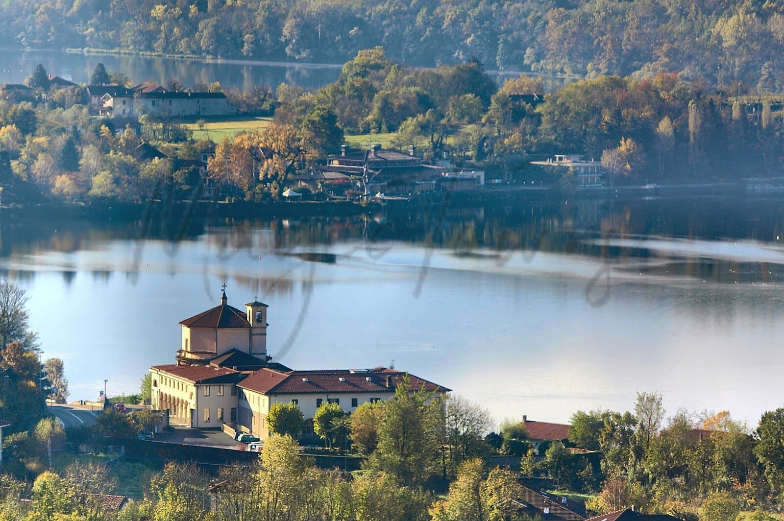
Avigliana in Piemonte hosts several outdoor activities and trails appealing to expats and retirees. The Parco Naturale dei Laghi di Avigliana spans 400 hectares, offering diverse ecosystems. Within its boundaries, the Avigliana Lakes Tour is a moderate 4.9-mile trail encompassing both Lake Piccolo and Lake Grande, notable for its child and dog-friendly features. The Trail of the Princes, a 5.9-mile moderate path, showcases panoramic views and historic landmarks like the Sacra di San Michele. Additionally, Giro Lago Grande offers an easy 2.5-mile trek, and the challenging 10.2-mile Monte Cuneo trail is available for seasoned hikers.
✅ Pros
– High-quality healthcare with excellent facilities and services.
– Pleasant climate with warm summers and mild winters.
– Rich cultural and historical heritage to explore and enjoy.
– Low unemployment rate, offering stable economic environment.
– Good integration opportunities with friendly local community.
– Some tourism presence, enhancing local vibrancy and amenities.
– Satisfactory air quality for a healthier living environment.
– Accessible transportation options for easy travel and commuting.
– Reasonable infrastructure supporting daily living conveniences.
– Internet connectivity suitable for remote work and leisure activities.
❌ Cons
– Limited nightlife options for those seeking vibrant evening activities.
– Infrastructure could be more developed for modern conveniences.
– Small-town atmosphere may feel isolating for some expats.
– Public transportation might not be frequent enough for convenience.
– Language barrier can pose challenges for non-Italian speakers.
– Limited shopping options compared to larger cities nearby.
– Seasonal tourist influx can lead to overcrowded attractions.
– Internet speed may not satisfy all remote work needs.
– Mild winters can feel damp and chilly at times.
– Fewer cultural events compared to larger urban centers.
FAQs
Summary
Nestled in the foothills of the Alps, Avigliana offers a blend of historical charm and natural beauty, making it appealing to expats and retirees seeking a tranquil lifestyle. The town boasts a picturesque medieval center with cobblestone streets and notable attractions such as the Castle of Avigliana and the striking Sacra di San Michele abbey. These sites not only provide historical insight but also stunning views of the surrounding Susa Valley and the fragrant lakes nearby, ideal for outdoor activities like hiking and boating.
While its proximity to Turin enhances accessibility—just a half-hour train ride away—expats might find the slower pace of life a contrast to larger urban centers. Local amenities are sufficient, but some may miss the wider variety found in bigger cities. However, Avigliana’s strong sense of community and rich culinary traditions rooted in Piedmontese culture, including local wines and dishes, enrich the living experience for those ready to embrace small-town life.
✅ Pros
– High-quality healthcare with excellent facilities and services.
– Pleasant climate with warm summers and mild winters.
– Rich cultural and historical heritage to explore and enjoy.
– Low unemployment rate, offering stable economic environment.
– Good integration opportunities with friendly local community.
– Some tourism presence, enhancing local vibrancy and amenities.
– Satisfactory air quality for a healthier living environment.
– Accessible transportation options for easy travel and commuting.
– Reasonable infrastructure supporting daily living conveniences.
– Internet connectivity suitable for remote work and leisure activities.
❌ Cons
– Limited nightlife options for those seeking vibrant evening activities.
– Infrastructure could be more developed for modern conveniences.
– Small-town atmosphere may feel isolating for some expats.
– Public transportation might not be frequent enough for convenience.
– Language barrier can pose challenges for non-Italian speakers.
– Limited shopping options compared to larger cities nearby.
– Seasonal tourist influx can lead to overcrowded attractions.
– Internet speed may not satisfy all remote work needs.
– Mild winters can feel damp and chilly at times.
– Fewer cultural events compared to larger urban centers.
Related Posts
More questions about Avigliana ? Ask Magic AI.
Our innovative AI assistant is eager to help. Try it out here: