
Elevation
[?]
Elevation of a city refers to the height above sea level at which the city is located, measured in meters.
287
Population
[?]
This is a town's official population, measured each year by the national statistics authority.
13700
Real Population (5km)
[?]
Our "Real Population" metric reflects more accurately a town's real size by including inhabitants in the immediate vicinity of the town's official borders.
128200
Air Quality Rating
[?]
Based on PM10, PM2.5, NO2, SO2, and ozone levels. Higher scores indicate cleaner air.
92
Region
Lazio
Walkability
Very Walkable
Housing availability
[?]
Based on total number of properties (sale and rent) classifies housing availability into five categories: low, relativel ylow, medium, relatively high and high.
Low
Avg Download Speed (Mbps) / Avg Upload Speed (Mbps)
140
/ 70
Climate Description
Mild climate, warm summers, cool winters, minimal snow, abundant sunshine, Mediterranean allure.
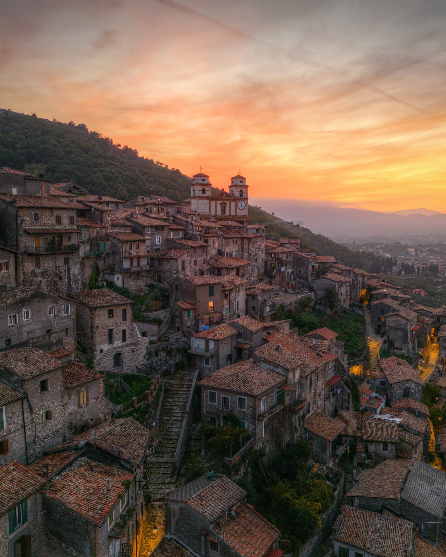
Artena
Lazio
Hilltop town near Rome with Europe’s largest pedestrian Old Town, historic structures, and vibrant festivals.
Quality of Life Score
[?]Factors in air quality, amenities, walkability, population, and environmental risks. Higher scores suggest better living conditions.
83
Quality of Infrastructure
[?]Measures internet speed, healthcare access, airports, rail, and walkability. Higher scores mean better connectivity and essential services.
57
Quality of Economy
[?]Based on income, property prices, job availability, and population density. Higher scores indicate stronger economic conditions.
64
Artena Demographics
Population
[?]
This is a town's official population, measured each year by the national statistics authority.
13700
Real Population (5km band)
[?]
Our "Real Population" metric reflects more accurately a town's real size by including inhabitants in the immediate vicinity of the town's official borders.
128200
Births Per 100 Deaths
70.0
Population Data Source
ISTAT,2023
Estimated Unemployment Rate
Touristy Index
[?]
Calculation of tourist density index for the city, comparing its total tourist number to the overall average tourist number of the region
relative to its own population.The index indicates how a location’s tourist density compares to the average, with values above
100 representing higher-than-average density and values below 100 representing lower-than-average density.
Not Touristic
Income per capita (2023)
[?]
This is an estimation of average income per resident for this town, based on 2023 data from the Italian Ministry of Finance.
19200
Income rank in Italy (2023)
[?]
This is a ranking of the town's average income per resident, against the full list of townships in Italy.
4723 out of 7901
Infrastructure and Connectivity
Create an account to explore more
This content is for Members only | Already a Member? Sign in
Infrastructure & Amenities
Create an account to explore more
This content is for Members only | Already a Member? Sign in
Healthcare
Create an account to explore more
This content is for Members only | Already a Member? Sign in
Housing & Property Market
Create an account to explore more
This content is for Members only | Already a Member? Sign in
Connectivity & Digital Access
Create an account to explore more
This content is for Members only | Already a Member? Sign in
Education
Create an account to explore more
This content is for Members only | Already a Member? Sign in
Climate & Weather
Create an account to explore more
This content is for Members only | Already a Member? Sign in
Precipitation
[?] Based on daily climate data for precipitation from OPEN-METEO this parameter indicates how a city's annual precipitation compares to others in terms of percentage, with values ranging from 0 (lowest) to 1 (highest). For example, a percentile rank of 0.75 means the city's total precipitation is higher than 75% of other cities.
Above Average (51st-60th percentile)
Sunshine
High (71st-80th percentile)
Snowfall
Low (11th-20th percentile)
Min Annual Temperature (°C)
[?] This parameter represents the monthly average of daily minimum temperatures for January, based on data from OPEN-METEO.
2.7
Max Annual Temperature (°C)
[?] This parameter represents the monthly average of daily minimum temperatures for January, based on data from OPEN-METEO.
29.8
Climate Description
Artena, located in Italy, enjoys a climate that balances sunshine and rain throughout the year, creating a comfortable environment for both locals and expats. The region experiences mild seasonal variations, with summers being warm but rarely oppressive. Winter months are cool, and snowfall is minimal, contributing to the town’s accessibility year-round. Sunshine is plentiful, allowing for an abundance of outdoor activities which retirees and Magic Towns readers might find appealing. The mild average temperature throughout the year ensures that Artena remains a favorable destination for relocation or extended visits, reflecting a typical Mediterranean allure without extreme weather conditions.
Annual Temperature Chart (Min)
Error
There was a problem with your SQL connection - Please contact the administrator
There was a problem with your SQL connection - Please contact the administrator
Annual Temperature Chart (Max)
Error
There was a problem with your SQL connection - Please contact the administrator
There was a problem with your SQL connection - Please contact the administrator
Sunny Days By Month
Error
There was a problem with your SQL connection - Please contact the administrator
There was a problem with your SQL connection - Please contact the administrator
Environmental & Air Quality
Create an account to explore more
This content is for Members only | Already a Member? Sign in
Classifications
PM10
[?]
PM10 levels indicate Good air quality at 0–20 µg/m³, Fair at 20–40 µg/m³, Moderate at 40–50 µg/m³, Poor at 50–100 µg/m³, Very Poor at 100–150 µg/m³, and Extremely Poor at 150–1200 µg/m³.
Good
PM2.5
[?]
PM2.5 is Good if PM2.5 levels are between 0–10 µg/m³, Fair between 10–20 µg/m³, Moderate between 20–25 µg/m³, Poor between 25–50 µg/m³, Very Poor between 50–75 µg/m³, and Extremely Poor between 75–800 µg/m³.
Fair
NO2
[?]
NO₂ levels are considered Good at 0–40 µg/m³, Fair at 40–90 µg/m³, Moderate at 90–120 µg/m³, Poor at 120–230 µg/m³, Very Poor at 230–340 µg/m³, and Extremely Poor at 340–1000 µg/m³.
Good
SO2
[?]
SO₂ levels indicate Good air quality at 0–100 µg/m³, Fair at 100–200 µg/m³, Moderate at 200–350 µg/m³, Poor at 350–500 µg/m³, Very Poor at 500–750 µg/m³, and Extremely Poor at 750–1250 µg/m³.
Good
O₃
[?]
For O₃, the air is Good at 0–50 µg/m³, Fair at 50–100 µg/m³, Moderate at 100–130 µg/m³, Poor at 130–240 µg/m³, Very Poor at 240–380 µg/m³, and Extremely Poor at 380–800 µg/m³.
Fair
Air Quality Rating
[?]
Based on PM10, PM2.5, NO2, SO2, and ozone levels. Higher scores indicate cleaner air.
92
Air Quality Description
Artena, Italy provides an appealing air quality profile that is conducive to well-being, particularly important for expats and retirees contemplating a relocation. The small particle contaminants measured in the environment commonly referred to as PM10 and PM2.5 are maintained at good and fair levels respectively. This suggests a lower risk of respiratory disturbances compared to more polluted locales. Concentrations of nitrogen dioxide and sulphur dioxide are commendably low, underscoring a lesser presence of typical industrial pollutants. However, levels of ozone hover at moderate, hinting at occasional peaks that could influence outdoor activities. Overall, Artena presents a breathable and health-supportive atmosphere.
Artena, Italy provides an appealing air quality profile that is conducive to well-being, particularly important for expats and retirees contemplating a relocation. The small particle contaminants measured in the environment commonly referred to as PM10 and PM2.5 are maintained at good and fair levels respectively. This suggests a lower risk of respiratory disturbances compared to more polluted locales. Concentrations of nitrogen dioxide and sulphur dioxide are commendably low, underscoring a lesser presence of typical industrial pollutants. However, levels of ozone hover at moderate, hinting at occasional peaks that could influence outdoor activities. Overall, Artena presents a breathable and health-supportive atmosphere.
Town Descriptions
Create an account to explore more
This content is for Members only | Already a Member? Sign in
Getting There
Artena is accessible primarily via the A1 motorway, which provides connections to Rome and Naples. The nearest airport is Ciampino, approximately 30 minutes away, while Fiumicino is slightly further. Two nearby train stations enhance regional connectivity, receiving moderate infrastructure ratings.
Getting Around
Local Cuisine
Artena, located in the Lazio region, boasts a rich culinary landscape deeply rooted in local traditions. Renowned traditional dishes include pasta alla carbonara, cacio e pepe, bucatini all’amatriciana, and abbacchio alla romana. These dishes highlight the region’s emphasis on high-quality ingredients such as guanciale (cured pork cheek), Pecorino Romano cheese, and seasonal vegetables like artichokes. In addition to traditional offerings, Artena hosts a variety of dining establishments ranging from rustic trattorias serving classic Italian fare to international cuisines, including Mediterranean and seafood options. While the dining scene is diverse, it presently features one Michelin-starred establishment, Marco Bottega Ristorante – Aminta Resort, noted for its upscale dining experience and innovative approach to local ingredients. The overall dining experience in Artena reflects both its traditional roots and a growing international presence, catering to various tastes and occasions.
Shopping Overview
The shopping landscape offers diverse options, including supermarkets, boutique clothing outlets, and dedicated shopping centres. Shoppers can find a variety of grocery stores alongside specialised outlets for men’s and women’s clothing, shoes, toys, and jewellery. Notably, there are also outlet stores that cater to those seeking discounted brands. Shopping centres provide a comprehensive retail experience, accommodating various preferences and needs.
Neighborhoods
Green Areas and Parks
Artena, Lazio offers two notable trails for outdoor enthusiasts. The Artena-Anagni trail spans 16.4 miles along the Via Francigena, featuring a challenging route with an elevation gain of 1,902 feet, crossing through Colleferro and the Sacco river. The Cammino di San Tommaso leads from Artena to Genazzano, covering 11.2 miles and providing both a cultural and naturalistic journey. Outdoor activities extend to biking and camping, with dedicated trails available for these pursuits. These trails cater to seasoned hikers and offer both cultural enrichment and substantial physical challenge.
✅ Pros
– Rich cultural and historical heritage to explore daily.
– Good air quality for a healthier lifestyle.
– Accessible healthcare facilities ensuring quality care.
– Close-knit community fostering integration and friendships.
– Convenient transportation options for easy commuting.
– Mild climate for enjoyable year-round outdoor activities.
– Low tourist traffic for a peaceful living environment.
– Affordable cost of living compared to larger cities.
– Opportunities for local markets and authentic Italian cuisine.
– Charming architecture and picturesque surroundings to enjoy.
❌ Cons
– Limited entertainment options for those seeking vibrant nightlife.
– Internet speeds may frustrate heavy users or remote workers.
– Healthcare quality could be better despite accessible facilities.
– Unemployment rate slightly higher than the national average.
– Public transportation may not be as frequent or reliable.
– Local shops may have limited variety for diverse needs.
– Language barrier could complicate daily interactions and services.
– Limited educational facilities for families with school-age children.
– Infrastructure score suggests some areas may need improvement.
– Small-town pace may feel too slow for some expats.
FAQs
Summary
Nestled in the Lepini Mountains, Artena is approximately 30 kilometers from Rome, making it an attractive option for expats seeking a blend of historical charm and modern convenience. This picturesque hilltop town features Europe’s largest pedestrian Old Town, characterized by narrow streets and historic structures, including the Palazzo Borghese and the Roger Lambrechts Archaeological Museum. Local culture thrives through vibrant festivals such as the Feast of Our Lady of Grace and various culinary events showcasing traditional dishes like polenta and gnocco.
With a population of around 13,600, the town offers a close-knit community atmosphere, complemented by an admirable air quality. However, expats should note the limited access for vehicles in the historic center and the nearby beach, which is 24 km away. While services are manageable, the reliance on donkeys for urban services and the slower pace may require some adjustment for newcomers.
✅ Pros
– Rich cultural and historical heritage to explore daily.
– Good air quality for a healthier lifestyle.
– Accessible healthcare facilities ensuring quality care.
– Close-knit community fostering integration and friendships.
– Convenient transportation options for easy commuting.
– Mild climate for enjoyable year-round outdoor activities.
– Low tourist traffic for a peaceful living environment.
– Affordable cost of living compared to larger cities.
– Opportunities for local markets and authentic Italian cuisine.
– Charming architecture and picturesque surroundings to enjoy.
❌ Cons
– Limited entertainment options for those seeking vibrant nightlife.
– Internet speeds may frustrate heavy users or remote workers.
– Healthcare quality could be better despite accessible facilities.
– Unemployment rate slightly higher than the national average.
– Public transportation may not be as frequent or reliable.
– Local shops may have limited variety for diverse needs.
– Language barrier could complicate daily interactions and services.
– Limited educational facilities for families with school-age children.
– Infrastructure score suggests some areas may need improvement.
– Small-town pace may feel too slow for some expats.
Related Posts
No posts found for the town.
More questions about Artena ? Ask Magic AI.
Our innovative AI assistant is eager to help. Try it out here: